
Middlesex Canal Association P.O. Box 333 Billerica, Massachusetts 01821
www.middlesexcanal.org
| Volume 51 No. 3 | April 2013 |
MCA ACTIVITIES
 Please mark your calendars.
The Association is sponsoring two bicycle tours of the canal, south from Lowell on Sunday, April 7th, and north from Charlestown, likely on Saturday, October 5th.
Our Spring Meeting will be held on Sunday, April 28th, 2013, in the museum, beginning at 1:00pm. There will be an election of officers, also, bylaw change proposals will be presented and voted on. Following the business meeting, our speaker will be Dr. Patrick Malone, author of "Waterpower in Lowell". Refreshments will be served.
The MCA-AMC Spring Walk will take place in Wilmington on Sunday, May 5th.
See the Calendar, following, for more information on our activities. Also included in the calendar are meetings and tours, sponsored by other canal and related organizations, in which you may want to participate.
Please also check our web site now-and-then, at the URL noted in the nameplate, above, which also lists canal-related events and topics of potential interest, sometimes including those that don't make it into Towpath Topics.
PRESIDENT'S MESSAGE
by J. Jeremiah Breen, jj@middlesexcanal.org
The MCA invites active participation by more of our members and proprietors.
Currently, fifteen proprietors serve on the Board of Directors and thereby run the Middlesex Canal Association. The Association's annual scheduling requirement is: to staff the visitor center/museum every Saturday and Sunday, except holidays, up to 104 days/year; to lead towpath walks along the route of the canal in the spring and fall, these are conducted jointly with the Appalachian Mountain Club; also in the spring and fall, to lead bicycle rides along the full 27-mile length of the canal; to arrange three annual meetings with guest speakers and refreshments at the museum; and to publish three issues of Towpath Topics, fifty years of back issues of which are digitized and searchable at www.middlesexcanal.org. All of this is available for free to the public. Among the fifteen proprietors, six elders, 76 years old and older, stalwarts on the board of directors, do a large part of the work to make this annual schedule possible. Most of the remaining nine proprietors also contribute as they can, but have full-time jobs.
An example of a stalwart would be the late Dave Dettinger. A search on "Dettinger" at middlesexcanal.org produces 77 hits, a partial record of his support for the Association. He was a signer of the Association's Articles of Incorporation at age 44 and was still attending directors' meetings at 92, the year he died.
One way to gather new proprietors who would be stalwarts is for the present proprietors and members to offer to guide a tour of the part of the canal in each of the nine canal towns to the historical society in that town. Appendix 6 of Clarke's Middlesex Canal is a ready walking guide organized by towns. A local historical society would have a direct interest in sponsoring and advertising the tour and might provide a driver and van for accommodating the less mobile. Now is the best time to do a tour before summer leaves have obscured the canal and landscape.
For distant associates, Roger Hagopian's Journey Along the Middlesex Canal is a thorough, well done video with voice, music and graphics. At 25 minutes long, it is an excellent base for a talk to a historical society. It can be downloaded from middlesexcanal.org. Highly recommended to the new proprietor in Palomar Mountain, California.
If you can say Welcome!, you can be a volunteer at the museum. Simply come to the museum at any time between noon and four, Saturday or Sunday, prepared to greet visitors at the reception desk. An experienced docent will be present to answer questions by visitors, but with you at reception, the docent will be able to do more of the other work required to keep the museum open and free.
Please participate, actively, in whatever way you can!
J. Jeremiah Breen
TABLE OF CONTENTS
MCA Activities
President's Message (J.J. Breen)
Calendar of Events
For Future Planning
Fifty Years of ... Towpath Topics
Canal Boat Ride Concessions
Notice of Amendment of Bylaws
Folk Art Sale (Gerber & Williams)
Middlesex Canal Bridges (Gerber)
Principal [US] Canals, circa 1839
New Stamp Issue - A Baldwin Apple (Bigwood)
Miscellany
CALENDAR OF EVENTS
Middlesex Canal Association (MCA) and Related Organizations
First Wednesday - MCA Board of Directors' Meetings - The Board meets at the Museum, from 3:30 to 5:30pm, the first Wednesday of every month, except July and August. Members are always welcome to attend.
Directions to the Museum/Visitors Center: Telephone: 978-670-2740.
By Car:
From Rte. 128/95, take Route 3 toward Nashua, to Exit 28 "Treble Cove Road, North Billerica, Carlisle". At the end of the ramp, turn left onto Treble Cove Road toward North Billerica. At about ¾ mile, bear left at a fork. After another ¾ mile, at a traffic light, cross straight over Route 3A. Go about ¼ mile to a 3-way fork; take the middle road, Talbot Street, which will put St. Andrew's Church on your left. Go about ¼ mile and bear right onto Old Elm Street. Go about ¼ mile to the falls, where Old Elm becomes Faulkner Street; the Museum is on your left and you can park across the street on your right, just beyond the falls.
From I-495, take exit 37, N. Billerica, south to the road's end at a "T" intersection, turn right, then bear right at the Y, go 700' and turn left into the parking lot. The Museum is across the street.
By Train: The Lowell Commuter Line runs between Boston's North Station and Lowell's Gallagher Terminal. Get off at the North Billerica station, which is one stop south of Lowell. From the station side of the tracks, the Museum is a 3-minute walk down Station and Faulkner Streets on the right side.
Sat, Apr 6, 2013, 8:30am - Lock Tender Training, conducted by Lowell Parks and Conservation Trust, supporting Concord River Whitewater Rafting. To be held at 8:30am at the UMass Lowell Inn & Conference Center, 50 Warren Street, Lowell, MA. Learn to operate a "real" lock! Training is conducted at Warren Locks on the Pawtucket Canal (aka Lower Locks and Concord Locks). Volunteer lock tending shifts are Saturdays and Sundays thru April and May and last from 10:30am to 12:00pm and 2:30pm to 4:00pm. Proper training and a signed release form are required for all lock tenders. For further information - Gwen Kozlowski, Stewardship & Education Manager (gwen at lowelllandtrust.org), Mon. to Thurs., 8:30am to 4:30pm.
Sun, Apr 7, 2013 - Spring Middlesex Canal Bicycle Ride. Meet 9:30am at North Station (commuter rail) and take our bicycles on the 10am train to Lowell. (Riders can also board at West Medford at 10:11am or meet the Train when it arrives in Lowell at 10:43am). Route visits the Pawtucket and other Lowell canals, the river walk, Francis Gate, and then Middlesex Canal remnants in Chelmsford. Lunch at Route 3A mini-mall in Billerica. Quick visit to Canal Museum, then on to Boston. Long day, but sunset is late. Riders needing to leave early can get the train to Boston at 1:07pm at North Billerica or at 3:14pm at Wilmington. Participants are responsible for one-way train fare [$6.75 from Boston to Lowell]. Complete Lowell line schedules can be downloaded at http://www.mbcr.net for anyone who wishes to plan a rail travel itinerary specific to their needs. For any changes or updates, see http://middlesexcanal.org. Leaders Bill Kuttner (617-241-9383) & Dick Bauer (857-540-6293).
Fri-Sun, Apr 5-7, 2013 - The Canal Society of Indiana's spring tour of the Wabash & Erie Canal, Attica to Montezuma, Indiana. HQ: Sleep Inn, Danville, Illinois. See canal remains, murals, a covered bridge, a war memorial museum, a waterfall, and much more on this three-day adventure. For more information, call 260-432-0279.
Mon-Fri, Apr 22 to May 24, 2013 - National Canal Museum - Immersion Days - Hugh Moore Park - Easton, PA. Immersion Days are day-long programs bring history, science, and technology to life for middle school children. The programs are aligned with the PA/NJ science and social studies curricula for 4-5th grades and inform learners about the people, processes, and products that forged the Industrial Revolution in eastern Pennsylvania. The revolution transformed the region from an agricultural economy to a leader in the industrial and transportation revolution. Students participate in activities at four main stations: Canal Life, Buoyancy, Simple Machines and Blacksmithing. Call 610-991-0503 for additional information.
Directions to Hugh Moore Park: from I-78, follow signs for Route 611 north 1.3 miles; turn left at end of bridge onto Larry Holmes Drive; turn left (1 block) onto Lehigh Drive; go 2 miles and turn left onto bridge into Hugh Moore Park. From Route 22, take 25th Street 2 miles south. For more information call the National Canal Museum at 610-991-0503.
Fri-Sun, Apr 26-28, 2013 - The Annual Meeting of the American Canal Society will be held in conjunction with the Joint - Canal Society of NY State and Pennsylvania Canal Society's spring tour of the northern end of the Delaware and Hudson Canal, Kingston to Port Hyxson. The ACS meeting is scheduled for Fri, Apr 26 from 3-5pm at the Holiday Inn in Kingston. In addition to exciting 19th century canal sites, including a Roebling canal aqueduct remnant, we will see the Hudson River port at Roundout where the canal meets the river, and the historic Rosendale cement industry, a canal museum, and a maritime museum. A boat trip to a Hudson lighthouse and up the Roundout is possible as well. See newyorkcanals.org, pacanalsociety.org/fieldtrips.htm, and/or americancanals.org/Calendar/Calendar.htm for further information and updates.
Apr 26-28, 2013: Virginia Canals & Navigations Society Spring Conference and Paddling Trip: celebrating the 250th anniversary of Thomas Jefferson's trip to open the Rivanna River to navigation. Events include a paddling trip on the Rivanna, a driving tour of historic sites along the Rivanna, including lock sites and historic sites in Palmyra, and a lecture on the Rivanna River as it was then and as it is now. For complete details, see www.vacanals.org.
Sun, April 28, 2012 - MCA's Annual Spring Meeting will take place in the museum, at 1:00pm. Proposed changes to our Bylaws will be presented and voted on and election of officers for the forthcoming year will occur at that time. Following a short business meeting, our speaker will be industrial archaeologist and historian of technology Dr. Patrick Malone, Professor Emeritus of American Civilization and Urban Studies and former Director of the Urban Studies Program at Brown University. His topic, Waterpower In Lowell is the subject of a book he recently published. Refreshments will be served.
Sun, May 5, 2013 – Joint MCA-AMC Spring Middlesex Canal Walk. Meet at 1:30pm; Wilmington, MA. Walk a rural section of the canal from near the Wilmington Town Park to Patch's Pond, once a canal basin. Examine grooves worn in a boulder by towropes as boats wound around the Ox Bow; also the remains of Maple Meadow Brook Aqueduct, and a quarry used in its construction.
Directions: From Route 128/95 take exit 35 in Woburn. Follow Route 38 (Main St.) north 2.4 miles to the Wilmington Town Park on the left just prior to the railroad overpass. For more information see our web site - middlesexcanal.org or contact: Roger Hagopian (781-861-7868) or Robert Winters (617-661-9230, robert@middlesexcanal.org).
May 11, 2013 - Cooper & Santee Canal Park, Guided Interpretive Walk, 9am-11am. Allow our educators to show you both the historical and natural beauty of Old Santee Canal Park. One mile walk includes stairs, boardwalk and gravel, meet at the Interpretive Center. The guided tour includes the Stony Landing Plantation house and an easy 1 mile nature hike through Biggin Swamp. Many wading birds as well as alligators, turtles, and nesting ospreys may be observed during this trip. Free with regular admission. Register by Thursday, May 24, 2012. For more information, contact: Brad Sale (bssale at santeecooper.com).
Sun, May 19, 2013 at 1:30pm - National Canal Museum - Heritage Walk - Hugh Moore Park - Easton, PA. presented by Charles Derr, Park Ranger, Retired, free and open to the public. The Lehigh Navigation walk will begin at the Canal Boat Store at 1:30pm. Cancelled by inclement weather. Check www.canals.org for additional dates and information.
Wed to Sun, Jun 5 to Sept 2, 2013 - National Canal Museum - Canal Boat Rides. Memorial Day weekend to Labor Day, then weekends only in Sept; Rides hourly, 1-4pm. Adults - $11.75; Seniors - $10.50 (65 and older) ; Children (3-15) - $9.00; Children (2 and Under) - FREE. Admission includes the Museum. See the Josiah White in action: canals.org/movies/canalsJosiahWhiteII1.wmv. About our mules: canals.org/movies/canalsMules1.wmv.
June 15-22, 2013: - James River Batteau Festival - an eight day, 120 mile trip from Lynchburg, VA to Richmond, VA event featuring authentic replicas of the 18th century batteaux, the sleek, shallow-draft merchant boats upon which the Old Dominion rode to its first era of economic prosperity. The route travels through 18th century batteau sluices and under aqueducts. Other paddlers and spectators also welcome to participate. For complete details, see vacanals.org.
July TBA - National Canal Museum - Canal Days, a weekend celebration of canal life, with activities for the entire family, will be held Sat. and Sun. Please check www.canals.org for information later in the spring.
Sept 16-19, 2013 - World Canals Conference in Toulouse, France, along the Canal du Midi, with accompanying excursions prior to and following. See wcc13.com/en for details.
Sept 20-22, 2013 - The Canal Societies of Indiana and Ohio will sponsor a trip to Delphi, Indiana.
2014 - World Canals Conference, Navigli Lombardi, Milan, Italy
FOR FUTURE PLANNING
Tentative Dates for Fall MCA activities are as follows:
October 5, 2013 - 11th Annual Bike Tour North, starting at 9:00am
October 20, 2013 - MCA-AMC Fall Walk in Woburn
October 27, 2013 - Fall Meeting, 1:00pm at the Museum .
These dates may change slightly based upon the personal schedules of trip leaders and speakers.
A REMINDER
Fifty years of back issues of Towpath Topics, together with an index to the content of all issues, are available online at middlesexcanal.org/towpath. These are an excellent resource for anyone who wishes to learn more about the canal and should be a goldmine for historic research.
CANAL BOAT RIDES
Will you be traveling this summer? The American Canal Society maintains an annotated list of more than two-dozen canal boat ride concessions that operate at various places in the eastern USA and parts of Canada. Go take a ride!
Linda Barth, editor of American Canals, newsletter of the ACS, is currently verifying that the listed concessions will again be operating during the summer of 2013, and determining their schedules. The list is available to you on-line at americancanals.org/Canal_Boats/Canal_Boats.htm. Linda's updating efforts should all be completed and posted by early April.
NOTICE OF AMENDMENT OF BYLAWS
The by-laws may be amended by a vote of 2/3 of the Proprietors present and voting at any annual meeting or at a special meeting called for such purpose, provided, in either case, notice of the contemplated action, including a detailed summary of the proposed amendment, is included in the notice of the meeting. (From the bylaws of the Association)
A vote to amend the bylaws will be taken at the annual meeting, April 28, 2013. The amended bylaws are available for review as a Google Doc at http://tinyurl.com/bylaws130428, where comments or questions and the response by the directors is a public record, lessening discussion at the annual meeting. The major change in the bylaws is the removal of the requirement for the election of members and proprietors. A detailed summary of the proposed amendment of the bylaws as recommended by the board of directors by motion carried February 6, 2013, is as follows:
I. PURPOSES
To acquire, restore and preserve all extant remains of the old historic Middlesex Canal; to
II. MEMBERSHIP AND DUES
1) Any person who is elected by a majority of the Proprietors present and voting at a regular or special meeting of the Association, and who has paid annual dues of ten twenty dollars or an amount recommended by the Board of Directors and approved at the previous annual meeting, shall be a Proprietor.
2) Any person may become a Member of the Association upon the payment of annual dues of five ten dollars or an amount recommended by the Board of Directors and approved at the previous annual meeting and complying with all the other requirements for election of Proprietors.
3) Such Members shall have all the rights and privileges of Proprietors, except only the right to vote and to hold office.
4) Proprietors and Members shall be entitled to a suitable card or certificate, as prescribed by the Board of Directors, attesting to their membership.
5) Any Member or Proprietor who fails to pay the prescribed dues for more than one year shall be automatically reinstated upon payment of the dues for each year in which they have not been paid, or such Member or Proprietor may be elected as a new member.
6) Any Proprietor who wishes to cease being a Proprietor may remain a member without further election by paying the reduced amount of dues when the same are due.
III. OFFICERS & DIRECTORS
d) To formulate and recommend to the Proprietors matters of policy, and to make rules and regulations, not inconsistent within with these by-laws, for the conduct of the Association's affairs and management of its property.
V. MEETINGS
4) Notice of meetings of the Board of Directors shall be given by the Corresponding Secretary, either personally, by mail, or by telephone at last at least five days before the date of the meeting if notice had not been previously given in Towpath Topics.
5) Notice of the regular annual and special meetings of the Association shall be given by the Towpath Topics by the Corresponding Secretary by mail by the Corresponding Secretary to all Proprietors and Members at least fourteen days before the date of the meeting if notice had not been previously given in Towpath Topics.
A FOLK ART SALE OF PASSING INTEREST
by Bill Gerber and Susan Williams
Susan, who provided the background information for the Baldwin and family genealogy article (see "… Family Thing" TT 3/2012) called my attention to the recent sale of a folk art painting that has been in the Brooks-Wheeler family of Watertown, Concord, Medford, and Winchester. Shown below, as it recently appeared on the Skinner auction house web site, the short description states: "American School, 19th Century' "The Junction formed in Medford by the Meeting of the [Mystic] River, Canal, and Railroad" Lot-68, Estimate $20,000-$30,000"). The estimate was a bit conservative, on March 3 the painting sold at a 'hammerprice' of $120,000!
 |
| The Junction |
| Skinner Auction House photo |
This painting is of interest to the MCA (No, we didn't bid on it!), a number of copies were made and sold as a means to fund publication of Carl and Alan Seaburg's book "The Incredible Ditch", with illustrations by Tom Dahill. This joint action by the MCA and the Medford Historical Society was explained in "Bicentennial Poster" TT 3/1993. Many MCA members have a copy. It's doubtful that the value has changed in any way; but it's nice to know you have an excellent copy of a folk art item of considerable value.
MIDDLESEX CANAL BRIDGES
by Bill Gerber
In 1794, when William Weston and Loammi Baldwin surveyed the routes for the Middlesex Canal, they identified a need for 28 bridges. The various histories claim that about 48 main-road and accommodation bridges spanned the canal. I'll take their word for it, though I expect that this number varied during the life of the canal, probably slowly increasing in number as populations and communities grew.
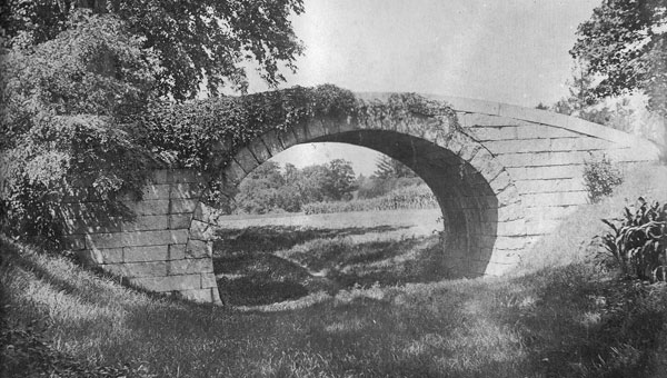
Governor John Brooks' Accommodation Bridge
When I first became interested in the Middlesex Canal, people in-the-know showed me drawings and photographs of 'The Brooks Bridge', an accommodation bridge linking two portions of Governor John Brooks' estate in Medford. About this bridge Lewis Lawrence tells us 'in 1821, while improving his estate, the Honorable Peter C. Brooks erected this elliptical arched stone bridge, at a cost of $1,000. It was built of Chelmsford granite brought down the canal toll free. It was one of the earlier works designed by George Rumford Baldwin, son of Loammi Baldwin, and replaced an old wooden bridge erected to carry a farm road over the canal. The name of the builder is unknown. The beautiful stone bridge remained for fifty-six years until it was sacrificed in the extension of the highway along the old canal.'
For a very long time I assumed that this was the standard design for bridges over the Middlesex Canal; after all, it's configuration is very similar to bridges I've seen over canals throughout England, such as the one shown below; and weren't they the 'model' for the bridges we built?
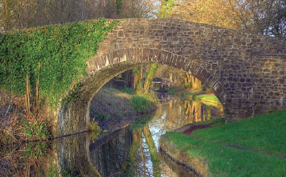
Typical English Canal Bridge (towpath on right)
I've since learned that, no, the Brooks Bridge was unique, the only one of its kind along the entire length of the canal. Instead, at least some of the other bridges were constructed along the lines of the bridge shown in the drawing below. This drawing, referred to as "Tay's Bridge", was erected near the Woburn-Wilmington line (and therefore may also have served as a "Change Bridge", see TT 3/2008 and 4/2010).
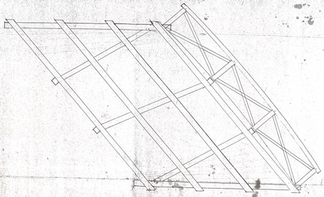
Tay's Bridge
From the records of the Middlesex Canal Company
Only one railing is shown in the drawing, but almost certainly there were two. Note that the bridge was built "skewed", so as not to change the direction of the road. This would have required longer structural members, and the forces resulting from traffic on it would have distributed quite differently than on a bridge that was aligned straight across. (Is the perspective of this drawing from the top down (i.e., looking down on the bridge), or from the bottom up? I think probably the former, otherwise the beams that brace the railings are on the top, i.e., the wrong side.)
I don't think we know enough to say that this was the only kind of bridge used on the canal, and certainly there are references to there having been two swing bridges, but there is evidence that Tay's Bridge was replicated at other sites as well. There are also indications that parts of bridges similar to it were fabricated at the Middlesex Canal Company's mills in North Billerica and transported to the sites where they would be erected.
Of the earliest bridges, those initially built as the canal itself was built (as compared to those enlarged when the canal was rebuilt by Caleb Eddy in the late 1820s) Historian Lewis Lawrence tells us "The bridges generally consisted of two stone abutments about 20 feet apart, one on each side of the canal. From one abutment to the other were laid wooden sills, or stringpieces, covered with plank and of sufficient height for the towing horses to pass under. The towing paths under the bridges were 6 or 7 feet wide. In 1808, the walls of the towing paths under the bridges were everywhere capped to prevent the stones from being thrown off by the boats. The larger portion of the bridges were accommodation bridges connecting parts of estates divided by the canal, the others being for highways."
One additional function that bridges sometimes served - "stop gates" were used at intervals along the canal to close sections of it, i.e., to stop the slow flow of water in emergencies (such as if there was a significant leak), and so that repairs could be done further down. Usually the stop gates were little more than a stack of heavy boards which could be inserted across the channel, and later removed without too much difficulty. These gates were placed on the upstream side so that the slow flow and water pressure would hold them against the bridge abutments. At Tay's Bridge, the arrangement was more refined; the historical record indicates that it was a swing gate that shut to the higher side of the embankment. Obviously, once used, the downstream section of the channel would have to be refilled to the same level as the upstream section before the gate could be reopened. The record doesn't indicate how this was done.
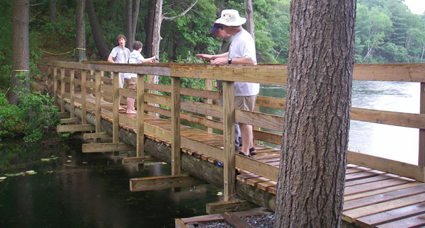
Photos of two contemporary bridges, built on the Tay's Bridge model, are shown below. Both of these are foot and light vehicle bridges, but they convey the idea of what bridges built on "Tay's model" would have looked like. There may have been some differences; e.g., it seems likely that, if Tay's Bridge was, in fact, a Change Bridge, then the railing may have been "beefed up" to cope with the stresses from towlines routinely scraping over and pressing on it. And obviously, neither of the open beams that brace the railings shown in the two photos would work very well as the bracing would snag the towlines. (But this problem might be alleviated simply by planking the end of the beams.)
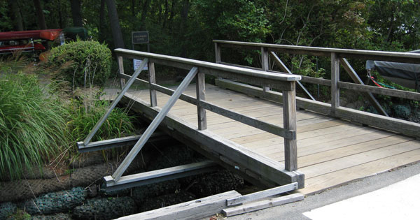
Photo by Tom Raphael
While the physical bridge is the most visible component of any bridge site, there are also abutments, possibly piers, and foundations for each of these. So what did the overall site of bridges over the Middlesex Canal look like?
In 1826, as part of his rebuilding program, Caleb Eddy recommended that 'in the future the towing paths under bridges should be built with long split stones with headers to prevent being thrown down by boats running into them'. The same year, the swing bridge over the tide-lock was rebuilt. (I've found no additional information about this bridge.) But, apparently this was not the only swing bridge, Lawrence also tells us that 'Bridge No. 9 was opposite Mr. Touro's avenue. It was a swing, or swivel, bridge which went to ruin. It had not been very satisfactory and probably was not rebuilt.'
We don't have a full picture of a bridge site as constructed in the early 19th century. But in July, 1830, George Rumford Baldwin measured and drew up a number of sectional drawings for his Civil Engineer brother, Loammi Baldwin (Jr.). A copy of these is shown below.
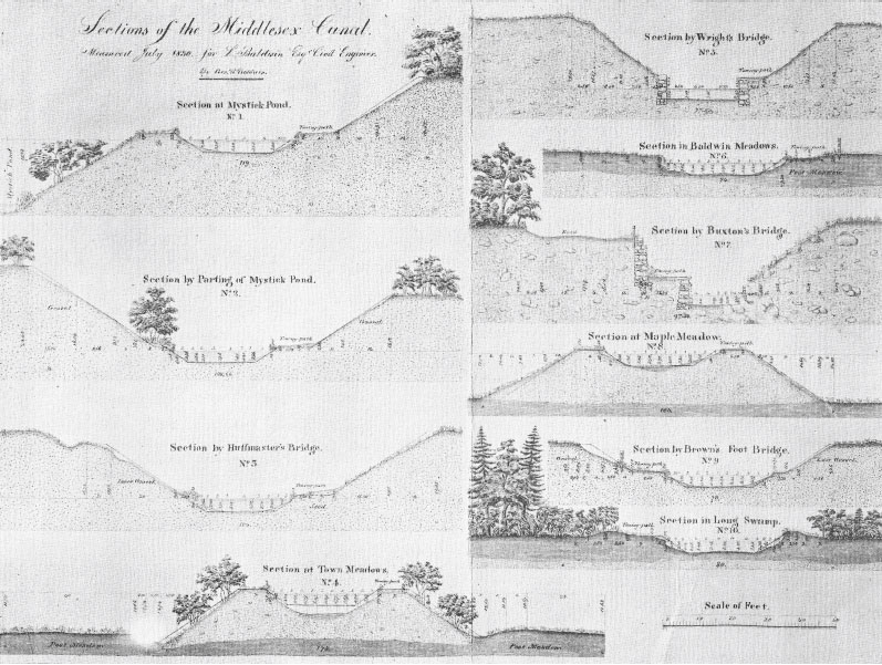
George R. Baldwin's Drawings of Measured Canal Sections
Of the 10 sections shown, four were made at bridge sites; i.e., at Huffmaster's, Wright's, Buxton's and Brown's bridges, the latter being a foot bridge. While the path of the bridge itself is not shown, G. R. Baldwin carried his measurements out to distant points on either side of the canal. If these indicate the points at which the bridges terminated, which seems like a reasonable assumption, then the respective measurements are approximately as shown in the following table.
| Bridge | Length of the Span | Height over Towpath | Width of Canal Beneath |
| Huffmaster's | 109' | 17' | 30' |
| Wright's | 83' | 16' | 24' |
| Buxton's | 99' * | 16' | 15' |
| Brown's (foot) | 86' | 9' | 32' |
* The section drawing suggests a Bridge Pier adjacent to the towpath
All of the bridge spans seem to be quite long to be entirely free-spans. Although not shown (except possibly for Buxton's Bridge), in addition to the abutments surely one or more piers were used to provide mid-span support.
Among the bridge-related questions that might arise are - were the bridges sufficiently high above the towpath that a horse, or perhaps a horse and rider would not have had to 'duck' to pass under; what limits, if any, would the height of the bridges impose on the load capacity of a boat, e.g., a boat stacked high with bales of cotton; and was the canal channel at the bridges of sufficient width to permit two boats to pass?
Horses are measured in "hands", a hand being four inches. Available information (e.g., see lovelongears.com/hands.html) suggests that typically most horses stand about 15 hands high at the withers (i.e., at the shoulder about where the mane ends) and a tall horse might range to 17 hands or so. These translate to five feet and 5'8", well below the nine foot height of Brown's foot bridge, the lowest clearance; thus, if these bridges are representative, then bridge height throughout the canal should provide no impediment to the passage of a horse, and probably not to any load either.
As for two boats passing, the standard trapezoidal canal prism is retained throughout under two of the bridges, Huffmaster's and Brown's thus it appears that the canal width would easily allow this,. (Conceivably, this might reflect a widening of the canal as part of the late 1820s rebuilding efforts initiated by Caleb Eddy, Agent (~CEO) for the canal company, to accommodate the increased traffic associated with the area's population growth and the servicing Lowell's textile mills.) However the canal is clearly too narrow under Buxton's Bridge to allow two boats to pass. This would have limited passage to one-way traffic, hence it would have been at least a minor bottleneck. While the channel width under Wright's Bridge is adequate to accommodate two boats side-by-side, passage would have required a bit more care in maneuvering on the part of the respective steersmen to avoid scraping or worse.
The Charles River Bridge: the Middlesex Canal Company's involvement with bridges didn't end with those erected over the canal. Together with Andrew Cragie's Lechmere Corporation and the Newburyport Turnpike Corporation, each entity holding one third of the shares of stock, the company became a partner to build a toll bridge across the Charles River between Boston and Cambridge. Shown in the figure below, the Canal Bridge was incorporated by an act of the legislature on February, 1808 and opened in August 1809. It was built from the end of Leverett Street in Boston, to the east end of Lechmere's Point in Cambridge, and thence to Barrell's Point in Charlestown. Paraphrasing from the legislation - it was to 'consist of two draws, with water-ways of 30 feet each, and draw piers, 150 feet long; the bridge to be not less than 40 feet wide, with a foot-way on each side divided from the drive-way by suitable railings; lamps to be not more than 50 feet apart, and to burn until midnight'. As completed the bridge was about 2,796 ft long and 40 ft wide with a draw 31.83 ft wide.
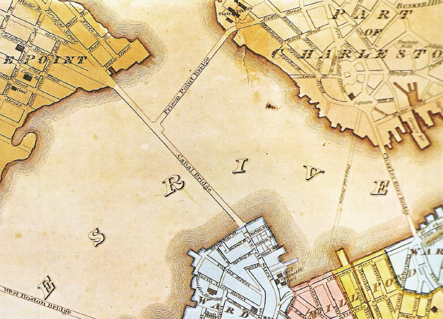
Canal (aka Craigie's) & Barrell's (aka Prison) Point Bridges
Plan of Boston, Wm Anin & Geo Smith, 1826, from Mapping Boston
The Middlesex Canal Corporation was given the authority to erect whatever locks and other works as were necessary for conducting the company's boats, for its whole length on either or both sides of the bridge. (There is no known evidence that these options were exercised.)
The Canal Bridge Corporation was authorized to collect tolls for 70 years following completion of the bridge , and then to surrender the bridge to the Commonwealth in good repair. Except pleasure craft, the toll was set at ten cents per ton for every vessel passing up through the draw, if over twenty tons' burden. (This clause was replaced January 25, 1820.)
The Medford Turnpike Bridge: in 1805, work was begun to build a branch canal to link the Middlesex Canal to the Mystic River in Medford. This project is particularly interesting because the constraints placed on the height of the turnpike bridge apparently drove the design of the branch canal. Though technically a project of the Proprietors of Medford Canal and Locks, i.e., owners of the Mystic River ship yards, Loammi Baldwin and other known canal engineering and construction entities were involved.
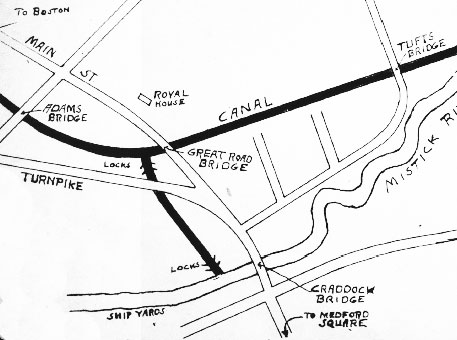
Plot of Medford Branch Canal
from the Leon Cutler Collection
In authorizing the branch canal, the Massachusetts legislature stated that [the Medford Turnpike Bridge, also referred to as a Traveling Bridge] "shall not be raised to a greater height from the top of said turnpike road, as it now is, to the upper side of the [bridge] planking, ... than four feet and six inches". To meet this significant constraint and provide adequate head room between the canal and the bridge above, the branch canal builders lowered the level of the canal as it passed under the bridge by building their top lock between the M'sex Canal and the turnpike as shown in the plot above. In a talk presented to the MCA in about 1985 (summarized in TT 10/1985), Henry Condon stated that "Each of the locks had a lift of ten feet ...". Given these together, the head room would have been about 14.5', less the thickness of the bridge structure, which likely was more than adequate in this case.
My sincere thanks to Tom Raphael, J. J. Breen, John Ciriello, Alan Seaburg, Fred Lawson and Duane Lucia for providing much of the resource materials used in preparing this paper.
PRINCIPAL CANALS OF THE UNITED STATES
Table provided by Susan Williams
Susan, who contributed so much to the Baldwin Family genealogy (see '… Family Thing' in TT 3/2012), found the table shown below in her great-great grandfather's copy of "Mitchell's Atlas" of 1839. The canals are listed geographically, roughly north-east to south-west. This reference was used by school children of that time. Though very conservative it's an interesting list; it evinces the expansion of canals as major arteries of transportation throughout the eastern USA following the Revolutionary War and well into the time of arrival of steam railroad technology.
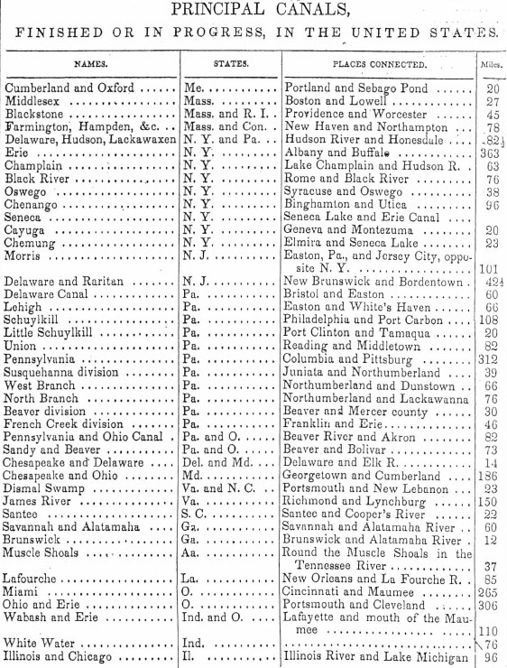
A number of known canals are missing from the table, and it lists few of the river navigations, i.e., rivers that had been canalized to support inland transportation, or even the bypass canals that made extended river travel possible. A few of the missing local and nearby canals and river navigations that come to mind include:
The length of the canals in the list totals to about 3600 miles. If the river navigations were added, the distance of navigable inland waterways would likely increase several times over. For example, in the case of south-central NH and eastern MA, adding the missing canals and river navigations to the length of the Middlesex Canal would more than quadruple the length of water transportation available in this area alone.
NEW STAMP ISSUE - A BALDWIN APPLE
by Betty Bigwood
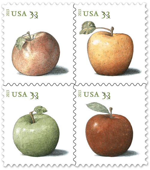 The USPS recently issued a new group of 33 cent postcard stamps commemorating apple production in New England. Four apples are highlighted: the multi-colored Northern Spy, the yellow Golden Delicious, the green Granny Smith, and the bright-red Baldwin. Designed by art director Derry Noyes, Apples features the work of John Burgoyne of West Barnstable. John has been illustrating since 1974 and is a long time Massachusetts resident. The art was done with pen and ink and watercolor, with some additional detail added on the computer. [from Stamp News Now, http://www.stampnewsnow.com/uspsnewissues.html]
"Spies are for pies!" is a reminder that generations of cooks have found the Northern Spy apple delicious when baked in desserts, cider and juice – and today scientists believe this apple, loaded with vitamin C and antioxidants, may be one of the best at keeping the doctor away.
The Golden Delicious apple, named for its yellow-gold skin and sweet flavor, is an excellent all-round apple, it makes a purée good for use in baby foods and is said to make the best apple butter!
The tart, green Granny Smith apple is one of the world's most well-known varieties. Its pleasingly sour flavor and crisp texture makes this juicy apple good for cooking or eating fresh.
Of the four, the Baldwin Apple is the only indigenous US apple – the others have all been imported. It is a good keeper and was much desired in the days before refrigeration. Juicy and aromatic Baldwin apples are delicious when eaten in season – fresh, cooked, or in baked goods – and are prized by makers of cider.
The Baldwin Apple is named after Loammi Baldwin (1744-1807), the Superintendent of Construction for the Middllesex Canal and its first Agent. His mansion stands proudly in North Woburn at the junction of Rte. 38 and Rte. 128. It was saved from demolition by a group of Woburn historians headed by Len Harmon, an action instigated by MCA Proprietor Fran VerPlanck.
Apparently the legendary story, that the Baldwin Apple was discovered during a survey for the Middlesex Canal, is not correct. The apple was discovered in the 1700's by William Butters in Wilmington. When first seen the tree was covered with woodpeckers who liked its taste too and for years it was known as the "woodpecker" apple. Loammi Baldwin heard about the tree, knew how to graft scions (cuttings) onto old apple trees, and propagated it. He had a large orchard in a field in North Woburn, across from the Thompson Library on Elm Street. Baldwin gave bushels of apples away to friends and played such a major role in advertising the brand that it was eventually renamed the Baldwin. The original tree was felled by a gale in 1815.
A monument to the Baldwin Apple stands today on Chestnut Street in Wilmington, Massachusetts. This granite obelisk with an apple on the top was erected in 1895 and is owned by the Rumford Historical Society of North Woburn.
We have recently had the wonderful assistance of Susan Williams to investigate the lineage of the Baldwin family. Susan discovered that John Chapman, otherwise know as "Johnnie Appleseed" was a distant cousin of Loammi Baldwin. Perhaps an "apple gene" runs in the family.
In 1934 there was a severe freeze which killed off half of the Baldwin stock and it has never regained its popularity. Perhaps this is because there are so many new varieties and we all have refrigerators!
Every Fall the Middlesex Canal Museum and Visitor Center hosts their Fall Meeting with Baldwin Apple Deserts. We have found an excellent source of this apple is The Honey Pot Nursery in Stow, Massachusetts. They are late in the scheme of ripeness so plan accordingly.
MISCELLANY
Estate Planning - To those of you who are making your final arrangements, please remember the Middlesex Canal Association. Your help is vital to our future. Thank you for considering us.
Museum & Reardon Room Rental - The facility is available at very reasonable rates for private affairs, and for non-profit organizations' meetings. The conference room holds up to 60 people and includes access to a kitchen and rest rooms. For details and additional information please contact the museum at 978-670-2740.
Web Site - As you may have noted in the nameplate, www.middlesexcanal.org is the URL for the Middlesex Canal Association's web site. Our webmaster, Robert Winters, keeps the site up to date, thus events and sometimes articles and other information will sometimes appear there before we can get it to you through Towpath Topics. Please do check the site from time to time for new entries. Also, the site now contains a valuable repository of historical information, all of the back issues of TT, and an index to all of the articles contained therein, can now be found there at http://middlesexcanal.org/towpath/.
Canal Game and Puzzle - The National Canal Museum has made a canal related game and a puzzle available on their web site www.canals.org/funandgames/. These include: a Boat Captain's Game - Can you run a canal shipping business successfully? And a Canal Lock Puzzle - would you know how to construct a canal lock and make it work? Give them a try.
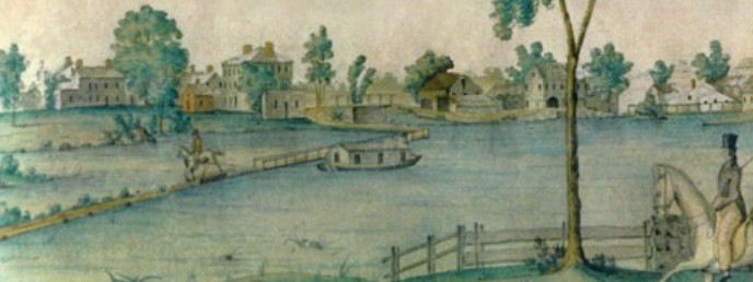
Nameplate - Excerpt from a watercolor painted by Jabez Ward Barton, ca. 1825, entitled "View from William Rogers House". Shown, looking west, may be the packet boat George Washington being towed across the Concord River from the Floating Towpath at North Billerica.
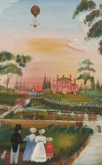
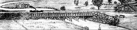
Back Page - Excerpt from an August, 1818, drawing (artist unknown) of the Steam Towboat Merrimack crossing the original (pre-1829) Medford Aqueduct.
Towpath Topics is edited and published by Bill Gerber and Robert Winters.
Corrections, contributions, and ideas for future issues are always welcome.