
Middlesex Canal Association P.O. Box 333 Billerica, Massachusetts 01821
www.middlesexcanal.org
| Volume 55 No. 3 | April 2017 |
Please mark your calendars
MCA Sponsored Events
Easter Sunday, April 16, 2017 Museum Closed
Spring Walk, 1:30pm, Sunday, April 23, 2017
Billerica Museum to Chelmsford
Annual Meeting, 1:00pm, Sunday, April 30, 2017
“Mary Stetson Clarke: Author, Scholar and Community Activist”
by her daughter Susan Stetson Clarke
50th Anniversary of the publication of The Limner’s Daughter
World Canal Conference, September 24-28, 2017
Syracuse, New York
200th Anniversary of the Erie Canal
15th Bicycle Tour North, 9:00am, Sunday, October 1, 2017
Fall Walk, 1:30pm, Sunday, October 15, 2017
Billerica Museum South
Fall Meeting, 1:00pm, Sunday, October 22, 2017
Speaker TBA
The Visitor/Center Museum is open Saturday and Sunday, noon – 4pm, except on holidays.
The Board of Directors meets the 1st Wednesday of each month, 3:30-5:30pm, except July and August.
TABLE OF CONTENTS
MCA Sponsored Events and Directions
Notice of Proposed Changes to MCA By-laws
Vice President’s Message by Traci Jansen
An Afternoon at the Museum by Deb Fox
The Baldwin Statue by Howard Winkler
Maple Meadow Brook Bone Dry in September 2016 by Howard Winkler
Winchester Culvert Part II by J. Jeremiah Breen
Editors’ Note
Dear Readers,
As I write this in March, the sky is gray and many inches of hard, heavy snow cover the yards and roofs, including the museum building, which I can see from my dining room table. And, although there have been blizzards in April before, hopefully by the time this issue of Towpath Topics is in your hands (or laptops), the temperature will be warmer and the snow melted.
Just in case we are still snowbound, sit in a comfortable chair and read our magazine! This month we have the second part of MCA President Breen’s article on the Winchester Culvert and his article on the proposed changes to the Middlesex Canal Association’s by-laws. Treasurer, Howard Winkler has two entries also, one about the Baldwin Statue in Woburn, and the other on Maple Meadow Brook. Find out what took place at the winter meeting of the MCA, and study the calendar to help plan your spring activities. Vice President Traci Jansen returns with more of her thoughts, as a follow-up to her wonderful letter in the Fall issue.
Also of import, recognized author Alan Seaburg has recently published a new e-book: A Social History of the Middlesex Canal. A review of Alan’s latest publication will be published in a future issue of this newsletter. In the meantime, check Alan’s e-publication out on his Anne Miniver Press website.
Stay warm and hope to see you at an event this spring.
Sincerely,
Deb Fox, Co-editor
MCA Sponsored Events and Directions to Museum
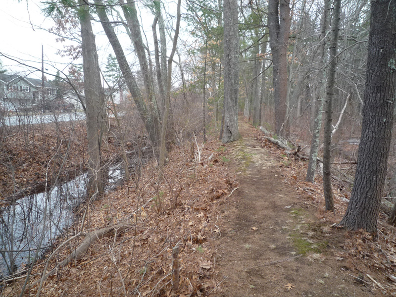
Spring Walk: This walk is jointly listed as a local walk of the Boston Chapter of the Appalachian Mountain Club and the Middlesex Canal Association. On Sunday, April 23, 2017, those planning to join the walk should meet at 1:30pm at the Middlesex Canal Museum and Visitors’ Center on 71 Faulkner Street in North Billerica. The 2½ hour walk will cover part of the Merrimack River branch of the canal in Billerica and Chelmsford, which is approximately 3 miles over generally wooded terrain. Sites to visit will include the recently restored guard lock, the anchor stone for the floating towpath that bridged the Concord River, and many stretches of watered canal. The walk will be led by Robert Winters and Marlies Henderson. For more information please visit www.middlesexcanal.org.
Marlies coordinated a clean-up effort in advance of the April 23rd canal walk. The work supplied by the Middlesex Sherriff’s Community Work Program saved the MCA considerable funds and should provide “happy trails” for the hikers.
Annual Meeting: On Sunday, April 30, 2017 at 1:00pm the Middlesex Canal Association will hold a public meeting at the Middlesex Canal Museum and Visitors’ Center, 71 Faulkner Street, North Billerica, MA. The featured speaker will be Susan Stetson Clarke on the 50th Anniversary of the publication of The Limner’s Daughter, one of many books written by her mother, Mary Stetson Clarke. Although fiction the story is “set in post-Revolutionary Massachusetts, depicting the introduction of the Baldwin apple, the construction of inland waterways, and patriotic prejudice, this novel reveals the struggle of a sixteen-year-old girl to understand and clear the mystery of her father’s reputation as she strides to build a home for her family” (www.worldcat.org). Among canal aficionados, Mary is widely known as the author of The Old Middlesex Canal, copies of which are available through the museum store. In the words of founding member and first president of the Middlesex Canal Association, Arthur L. Eno, Jr., after “ten year of exhaustive research, which started with the preparation of her Limner’s Daughter, Mary Stetson Clarke has written a comprehensive history of the Middlesex Canal.”
In addition to the lecture, the Board of Directors of the Middlesex Canal Association will hold a business meeting. Among the items on the agenda will be the election of officers and directors and a call for a vote on changes to the organization’s by-laws. [See below.]
15th Annual Bicycle Tour North: The 15th bicycle tour of the Middlesex Canal Association will be led by Dick Bauer and take place on Sunday, October 1, 2017. Riders should assemble at 9:00am at the Middlesex Canal Plaque at the entrance to the Sullivan Square T Station (1 Cambridge Street, Charlestown 02129). The 38-mile tour will head north following the route of the Middlesex Canal and will end in Lowell in time to meet the 5 o’clock train to Boston. For additional details and a tour schedule please Google: Canal Ride Cue Sheet. Participants are welcome to join the tour in progress.
Fall Walk: This walk is jointly listed as a local walk of the Boston Chapter of the Appalachian Mountain Club and the Middlesex Canal Association. On Sunday, October 15, 2017 those planning to join the walk should meet at 1:30pm at the Middlesex Canal Museum and Visitors’ Center on 71 Faulkner Street in North Billerica. The walk will take 2-3 hours, rain or shine, over generally level wooded terrain and streets. The route follows the canal for a round trip of approximately 3 miles south of the Concord River. Sites to be visited include: two guard locks; an anchor stone and the ‘peninsula’ at the opposite ends of the floating bridge that once carried the towpath across the Concord; the 1825 iron bolt pond-level reference; the “deep cut”; a smallpox memorial marker; and stretches of canal some of which are still watered. The walk will be led by Robert Winters and Marlies Henderson. For more information please visit www.middlesexcanal.org.
Fall Meeting: On Sunday, October 22, 2017 at 1:00pm the Middlesex Canal Association will hold a public meeting at the Middlesex Canal Museum and Visitor Center, 71 Faulkner Street, North Billerica, MA. The fall edition of Towpath Topics will include information concerning the featured speaker.
Directions to Middlesex Canal Museum and Visitors’ Center
By Car: From Rte. 128/95
Take Route 3 toward Nashua, to Exit 28 “Treble Cove Road, North Billerica, Carlisle”. At the end of the ramp, turn left onto Treble Cove Road toward North Billerica. At about ¾ mile, bear left at the fork. After another ¾ mile, at the traffic light, cross straight over Route 3A (Boston Road). Go about ¼ mile to a 3 way-fork; take the middle road (Talbot Avenue) which will put St Andrew’s Church on your left. Go ¼ mile and bear right onto Old Elm Street. Go about ¼ mile to the falls, where Old Elm Street becomes Faulkner Street; the Museum is on your left and you can park across the street on your right, just beyond the falls.
From I-495
Take Exit 37, North Billerica, south two miles to the stop sign at Mt. Pleasant Street, turn right, then bear right at the Y, go 700’ and turn left into the parking lot. The Museum is across the street (Faulkner Street).
By Train:
The Lowell Commuter line runs between Lowell and Boston’s North Station. From the station side of the tracks at North Billerica, the Museum is a 3-minute walk down Station Street and Faulkner Street on the right side.
Notice of Amendment of Bylaws
“The bylaws may be amended by a vote of 2/3 of the Proprietors present and voting at any annual meeting or at a special meeting called for such purpose, provided, in either case, notice of the contemplated action, including a detailed summary of the proposed amendment, is included in the notice of the meeting.” Amendments, Section VI, of the April 28, 2013 Bylaws of the Association, available as a Google Doc at http://tinyurl.com/bylaws130428.
A vote of the Proprietors to amend the bylaws will be taken at the annual meeting, April 30, 2017. The proposed new bylaws are available as a Google Doc at http://tinyurl.com/bylaws170430. They may also be viewed at http://middlesexcanal.org/bylaws.htm (current and proposed).
Changes recommended by the Board of Directors by vote of April 5, 2017 are detailed as follows:
III. MEMBERSHIP & DUES
1) Any person who is elected by a majority of the Proprietors present and voting at a regular or special meeting of the Association, and who has paid annual dues of twenty twenty-five dollars or an amount recommended by the Board of Directors and approved at the previous annual meeting, shall be a Proprietor.
2) Any person may become a Member of the Association upon the payment of annual dues of ten fifteen dollars or an amount recommended by the Board of Directors and approved at the previous annual meeting.
Add a new #7:
7) Members who have pre-paid a proprietor’s dues who are not elected shall be entitled to the difference in dues between associate and proprietor.
The following is a recommendation for a new section:
IX. Endowment Fund
1) The Endowment Fund of the Association is administered by the Treasurer under the direction of the Investment Committee, consisting of the President, the immediate past President, and a Director elected at the annual meeting.
2) The investment income of the Fund shall be reinvested until the Fund reaches $500,000.
3) Thereafter the income of the Endowment Fund shall be used as follows:
a) To provide a salary for an Executive Director
b) To further the purposes, section I, of the Association in the Middlesex Canal Heritage Park
4) Dissolution, Section VIII, applies to the Endowment Fund.
Vice President’s Message
Friends,
The Middlesex Canal Museum and Visitor Center is ready for Spring! Our Spring Walk from Billerica to Chelmsford will take place Sunday, April 23rd and our Spring Meeting happens Sunday, April 30th with author Susan Stetson Clarke as our guest speaker.
I’m most excited about the school visits from Wilmington third graders in May and June. We put together a program for children to have hands on experiences with Canal related topics in our Museum. Students measure the length of a canal boat and work with models to understand the size and scale of the project. The lock model lets us experience the careful engineering of the structures that allowed a level water path for the boats. We study primary resources to connect with the people and issues of the early 19th century. The groups venture outdoors to see the Concord River and imagine how the water once powered the Faulkner Mill. Kids go on a scavenger hunt through the Reardon Room and Exhibit Room to find Canal artifacts. And the fun continues to the Wilmington Town Park on a hike that leads to the remains of the Maple Meadow Brook Aqueduct, Ox Bow, and Canal prism.
Massachusetts third graders study Colonial America through the American Revolution as well as local history. Students can understand that the people of Massachusetts, after a newly gained independence, were looking to build and expand and live and work more efficiently. I appreciate the flow of topics in the Massachusetts Curriculum Frameworks at this age level and it relates wonderfully in all of the Canal towns (Lowell, Chelmsford, Billerica, Wilmington, Woburn, Winchester, Medford, Somerville, Charlestown) as students study the purpose and engineering and impact of the Incredible Middlesex Canal.
A few weeks ago, it was so rewarding to be approached by a Wilmington High School junior asking to do his Eagle Scout project with the Middlesex Canal Association. He explained that he visited the Museum when he was in third grade and studied about the Canal and it made a lasting impression so that he wanted to lead and contribute to a community project.
If you are interested in learning more about or even volunteering for our school visits, contact me at jansen.traci@gmail.com.
Happily,
Traci Jansen
Vice President
Middlesex Canal Association
An Afternoon at the Museum
by Deb Fox
Sometimes the best-laid plans can still hit a bit of a snag, as Bill Gerber found out on Sunday, March 5th. After being postponed and rescheduled due to a snowy weekend in February, the lecture of “Brick-Making Along the Merrimack” by Charles Mower, was again postponed. The speaker was a no-show due to a miscommunication. With a room full of Middlesex Canal Association members and friends facing disappointment, Association President J Breen stepped into the breech.
President Breen had the attention of an audience of 35 to 40 people for over an hour by discussing the 100th Anniversary of the Erie Canal and its relationship to the Middlesex Canal and the railroads that put them both out of business. The audience participated with questions and comments until the smell of Betty’s ham biscuits brought an end to the formal part of the afternoon.
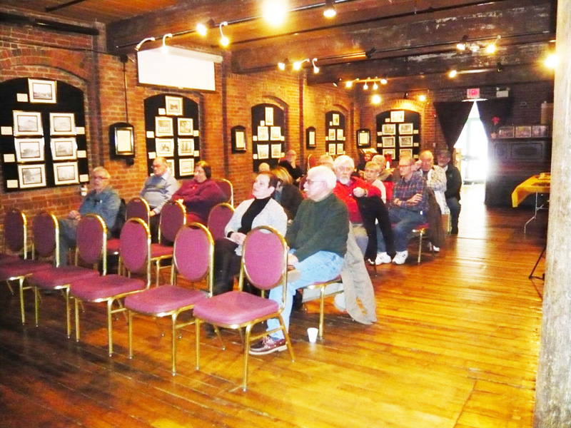
Refreshments followed; the previously mentioned ham biscuits were accompanied by egg salad sandwiches, a cheese and cracker platter, chocolate chip cookies, and two beautiful and delicious cakes, all to the delight of the attendees.
Bill Gerber generously offered to e-mail an article about brick-making in New Hampshire by James L. Garvin to everyone who provided him with an e-mail address, in attempt to atone for the absent speaker. It can safely be assumed that most visitors went home satisfied with their afternoon entertainment.
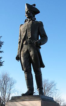
The Baldwin Statue
by Howard Winkler
I worked at a division of the Avco Corporation in Wilmington, MA from 1959 to 1974. The shortest route from my house in Arlington to work was to drive north on Route 3 to Route 128, then north to Route 38, passing the Baldwin statue over 5,000 times going to and from work. This past summer I made a special trip to the statue with the goal of documenting the inscriptions on the pedestal.
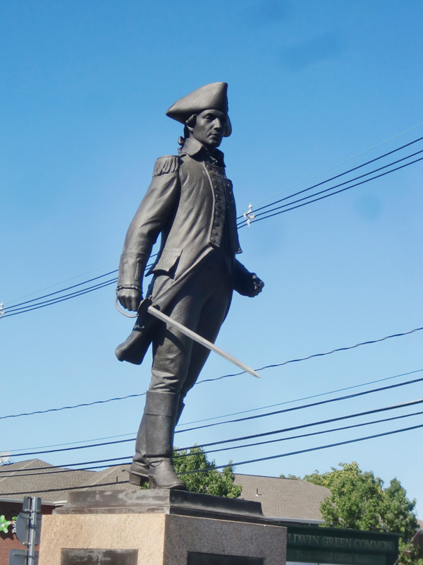
A PARTICIPANT WITH THE
RANK OF MAJOR
IN THE BATTLES OF
LEXINGTON AND CONCORD
A COLONEL OF
THE 26TH REGIMENT OF
THE CONTINENTAL ARMY
WITH GENERAL WASHINGTON
DURING THE OCCUPATION
OF NEW YORK
AND IN THE BATTLE OF TRENTON
LOAMMI BALDWIN
PATRIOT
PUBLIC OFFICIAL
BORN JANUARY 21, 1745 N.S.
IN NORTH WOBURN
MASSACHUSETTS
DIED OCTOBER 20, 1807
ONE OF THE PROPRIETORS
AND
A PRINCIPAL CONSTRUCTOR
OF THE MIDDLESEX CANAL
A MEMBER OF
THE COMMITTEE TO SIGN
THE PAPER MONEY OF
MASSACHUSETTS COLONY
FIRST SHERIFF OF
MIDDLESEX COLONY
UNDER THE STATE CONSTITUTION
A LEADER OF AFFAIRS
IN WOBURN
DISSEMINATOR OF THE APPLE
IN HONOR OF HIM CALLED
THE BALDWIN
WHICH PROCEEDED FROM A TREE
ORIGINALLY GROWING WILD
ABOUT TWO MILES NORTH
OF THIS MONUMENT
ERECTED IN COMPLIANCE WITH THE WILL OF
HIS GRANDDAUGHTER
CATHERINE RUMFORD GRIFFITH
BY HIS GREAT-GRANDSONS ROSWELL PARK
LOAMMI FRANKLIN BALDWIN AND BALDWIN COOLIDGE
EXECUTORS AND TRUSTEES
A.D. MCMXVII
HERBERT ADAMS SC[ULPTOR]
1917
The inscriptions on the four sides of the monument are an incisive summary of Baldwin’s many personal achievements and public contributions.
Baldwin lost his sword in the 1960s, and it has since been replaced. It probably did not fall off. Baldwin is not the only colonel to have lost his sword. Col. William Prescott was the commander of colonial forces at the Battle of Bunker Hill. His statue, on a pedestal, stands in front of the Bunker Hill Monument, and for a long time his sword was missing. Col. Robert Gould Shaw was the commander of the 54th Regiment Massachusetts (African-American) Volunteer Infantry which saw action at Fort Wagner near Charleston, SC. A bronze relief sculpture of Shaw and his regiment is located on Beacon St. adjacent to Boston Commons. His sword, as of this writing, is missing; it often goes missing.
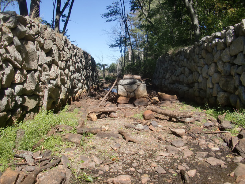
Maple Meadow Brook Bone Dry in September 2016
by Howard Winkler
I read in the Boston Globe of August 11, 2016 an article titled, Drought reduces Ipswich River to a shell of itself. The Ipswich is the source of public water for about 350,000 people. I knew that Wilmington is the watershed of the Ipswich, and Maple Meadow Brook is one of its major tributaries. On September 13, I drove to the parking lot on Route 38 by the Wilmington Town Park and walked in the bed of the Middlesex Canal, past the ledge in the Ox Bow with the rope marks made by canal boat tow lines, to the Aqueduct. There had been practically no rain from August 11 to September 13. When I reached Maple Meadow Brook it was bone dry as shown in the above picture. The supporting pier of the aqueduct in the center.
“Winchester Culvert: Location 2”
by J. Jeremiah Breen
 Start point for measuring 330’ |
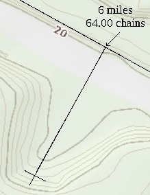
The Symmes River culvert begins 5 chains (330’) up canal from the basin at 6 miles, 64.00 chains, as measured in the 1829 survey by George R. Baldwin. In the January 2017 Towpath Topics, the reported location of the culvert found by measuring 330’ on the ground from the existing basin was contradicted by the remnants of the culvert found in 1964 sewer construction.
A second method for locating culvert using the basin and 330’ is the topographical map provided by the Town of Winchester at http://host.cdmsmithgis.com/WinchesterMA.
The perpendicular used here to locate the start point is 200 links (132’) long, as estimated by Baldwin. The 20’ cross line by the author is at the water elevation, 22.2’, in 1830.
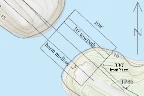
While the culvert location along the canal was drawn 330’ from the basin, the position transverse to the canal was drawn by extending property line between 3 and Edgewater Place. A sewer was constructed in the middle of the canal bottom in 1896 and became a property line in a 1956 subdivision. The Symmes River section was drawn on the the topo map above with the midline of its 20’ bottom congruent with the extended property line.
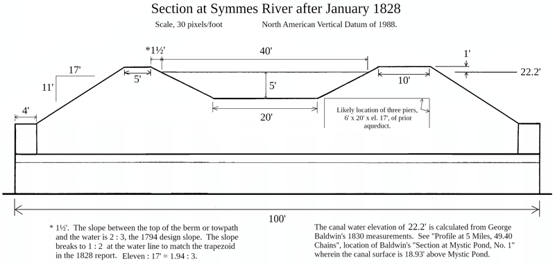
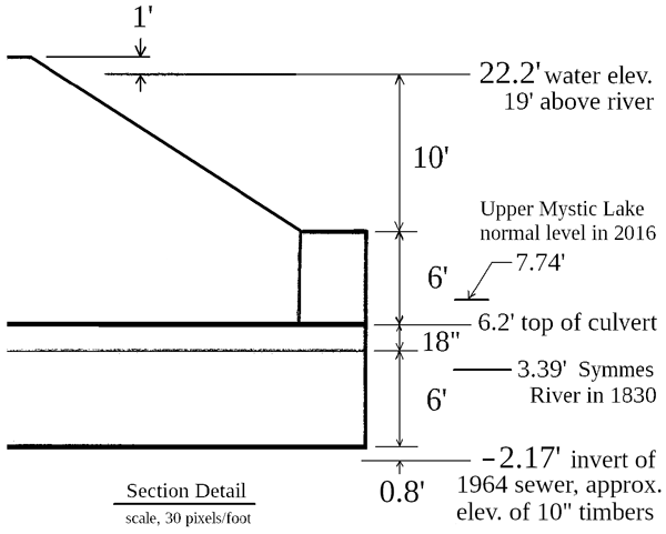
The dimensions in the above section are based on the 1828 report which was quoted in the January article except for the height of the side slope, 11’, chosen by the author to place the culvert low enough that the 10” timbers found in 1964 would be the “solid timber floors . . . sunk to the bottom of the river” in the 1828 report. As the “Section Detail” that follows1 shows, the culvert had little space left below the roof to accomodate the flow of a flood.
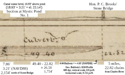
Profile at 5 Miles, 49.40 Chains
George Baldwin’s measurement in 1830 of the elevation, 18.23’ (NAVD88), of the lower miter sill of Gardner’s Locks provides a second method, scaling, for measuring the elevation of the canal water surface. See the sketch, “Winchester Culvert / Profile 6 miles, 69.31 chains” 2. The precise 22.14’ from a mile-and-a-quarter down canal is increased to a convenient 22.2’ in the “Section Detail”.
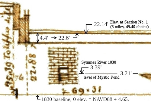
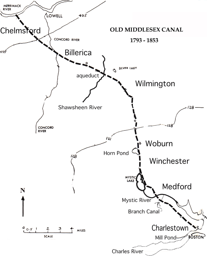
Profile at 6 Miles, 69.31 Chains
The Mystic River was spanned by a wooden aqueduct 135 feet long, and 14 feet wide inside, carried on 3 piers and 2 abutments of granite. The abutments were 100 feet apart, and the piers and abutments were each 20 feet long, 6 feet thick, and 12 feet high.3 The abutments and piers of the Symmes Aqueduct are here taken to be the same except the abutments were 120’ apart4 and the height is based on George Baldwin’s 1830 level survey where the the canal water is at el. 22.2’ and the river, 3.39’, ~ 19’ below.
Symmes Aqueduct in 1827 before building of retaining walls and embankment
Based on a drawing by Thomas Dahill, much changed by the author.
With 120’ between abutments, the Symmes Aqueduct is four spans of 25½’ separated by 3 6’-wide piers. The report of January 17, 1828 states the culvert walls were laid “directly under the old aqueduct.” Of course. The aqueduct remained in use during the 1827 boating season and was likely used in placing the granite for the culvert. The placement of the culvert walls below the aqueduct is calculated in the following placement table:
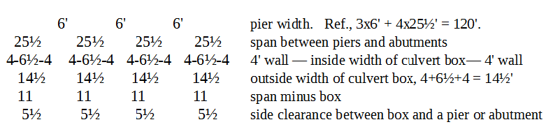
George Baldwin’s survey for his 1829 plan of the canal measured 1 chain, 67 links (107.6’) between south and north walls of the culvert.5 From the placement table, 14½ + 5½ + (6 of pier) + 2(25½ span + 6’ of pier) + 5½+14½ = 109’. If the two culvert boxes nearest the abutments had walls 6’ apart, the total is 108½’. Or a box could be off center of the 25½’ span. Baldwin’s 1829 measurement of 1 chain, 67 links (107.6’), is in agreement with the 4-box culvert horizontal placement.
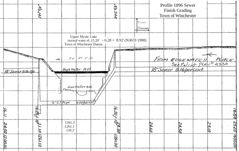
The drawing of the 1896 sewer6 records what appear to be remnants of the aqueduct. Manhole No. 141 is the manhole inside the 1959 parapet. No. 344 is on the property line between 3 and 4 Edgewater Place. The parapet is approximately Station 1275. The stone wall at Sta. 1295 could be a former pier with the remnants of the two other piers seen at low water. The wall at Sta. 1365 could be the northwest abutment. The 70’ between the two walls does not fit neatly into the placement table where the likely distance between walls is either 57’ or 87½’. The 1965 As-built Drawing of the second inverted siphon in January’s article has the southwest abutment at say, Sta. 1270, thus 87½’ is the expected distance between the walls. The 70’ is probably the distance between two imprecisely sketched walls.
In the January Towpath Topics article, explosives were suggested as being used to relieve a flood in Winchester Center caused by an ice jam at the culvert. The suggestion was based on Lawrence.7 Checking his references, (50p), a 1934 article by Ruth Coolidge has the following:
“in about 1865, an ice-jam, forced against the aqueduct, so raised the waters of Bacon’s Pond that cellars of homes in Winchester were flooded, and the aqueduct was blown up with dynamite.”8
But in a 1928 article, Moses Whitcher Mann included the Winchester town clerk’s Feb. 21 report of the flood of Feb. 16, 1855 and added “The flood of 1886 was of lesser depth though a serious one, because soon after that of ‘55, the canal aqueduct, three years disused, was removed. Its great blocks of split granite are in the foundations of the late Shepherd Brooks’ house9 and stable and the walls of the Brooks farmhouse on Grove Street.” 10 Coolidge (1880-1951) writing in 1934, lacks the authority of Mann (1846-1933), who, though writing in 1928, quotes an 1855 document, and adds his own experience of the flood of 1886. Coolidge and Mann were guides on the same excursion along the Middlesex Canal reported anonymously in 1932 where the dynamiting is also mentioned.
Mann also wrote in 1928 of a powder keg exploded in 1864 [Sabotage by a Confederate?], wrecking the Symmes-Bacon dam in Winchester, writing of the explosion from his contemporaneous knowledge of it.
An examination of the topographical map of Winchester indicates the extent of the 1855 flood as described by the town clerk is a good match with the 23.2’ elevation of the canal embankment over the Symmes River culvert. Mann writng in 1928 doesn’t report a flood as great as 1855 in the seventy years since the granite of the culvert was removed. The lack of a flood indicates the embankment was a dam, causing the flood, and the elevation of the flood indicates the water rose to the towpath and went over.
Notes
1. Baldwin’s “Section at Mystic Pond, No. 1” is in the Internet Archive, https://archive.org/details/Middlesex_Canal_Plan_and_Profile
2. “Winchester Culvert / Profile 6 miles, 63.31 chains” from https://archive.org/details/Middlesex_Canal_Plan_and_Profile.
3. Mystic Aqueduct in Lewis M. Lawrence, The Middlesex Canal (1942), p. 110.
4. Symmes Aqueduct in Lawrence, p. 111.
5. The measurements are in George Rumford Baldwin’s Field Book No. 5, September 1829, page 13, in the Baker Library (Harvard Business School), Baldwin Family Business Papers. A Xerox copy is in the library of the Middlesex Canal Visitor Center/Museum, Billerica MA 01862.
6. Conversion factor, Town of Winchester Datum - 6.28’ = NAVD 1988, is from a March 31, 2017 email from Sean Broderick of the town engineer’s office.
7. “The aqueduct was destroyed when, about 1865, an ice-jam was forced against it and so raised the water of Bacon’s Pond that cellars of houses in Winchester were flooded, and it was blown up with dynamite. Blocks of split granite from the ruins were used in building the walls of the Brooks farmhouse, and the foundations of Shepherd Brooks’ house and stable, on Grove Street, near Slow Pond. A few of the granite blocks still remain in or near the water at the site of the aqueduct. (50k) (50o) (50p).”. Lawrence, p. 111.
8. Medford Historical Register, Vol. 37, No. 3 (Sep 1934), “Historical Guide-Book of Medford” by Ruth Dame Coolidge, p. 40. Coolidge (1880-1951) was president of the Medford Historical Society for four years.
9. Shepherd Brooks (1837-1922) built the brick Shepherd Brooks Manor in1880. Peter Chardon Brooks III (1831-1920) built the granite, Italianate Point of Rocks in 1859. See http://www.brooksestate.org/pdfs/BrooksFamilyMedfordHeritageTrail2012.pdf
10. Medford Historical Register, Vol. 31, No. 3 (Sep 1928), “Upper Medford”, Moses Whitcher Mann et al., p. 67.
MISCELLANY
Back Issues - Fifty years of back issues of Towpath Topics, together with an index to the content of all issues, are also available from our website http://middlesexcanal.org/towpath. These are an excellent resource for anyone who wishes to learn more about the canal and should be particularly useful for historic researchers.
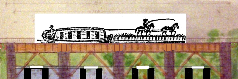
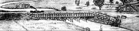
Back Page - Excerpt from an August,1818, drawing (artist unknown) of the Steam Towboat Merrimack crossing the original (pre-1829) Medford Aqueduct, probably on its way to service on the Merrimack River.
Estate Planning - To those of you who are making your final arrangements, please remember the Middlesex Canal Association. Your help is vital to our future. Thank you for considering us.
Museum & Reardon Room Rental - The facility is available at very reasonable rates for private affairs, and for non-profit organizations to hold meetings. The conference room holds up to 60 people and includes access to a kitchen and restrooms. For details and additional information please contact the museum at 978-670-2740.
Museum Shop - Looking for that perfect gift for a Middlesex Canal aficionado? Don’t forget to check out the inventory of canal related books, maps, and other items of general interest available at the museum shop. The store is open weekends from noon to 4:00pm except during holidays.
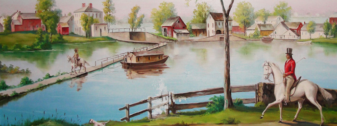
Nameplate - Excerpt from an acrylic reproduction of a watercolor painted by Jabez Ward Barton, ca. 1825, entitled “View from William Rogers House”. Shown, looking west, may be the packet boat George Washington being towed across the Concord River from the Floating Towpath at North Billerica.
Web Site – The URL for the Middlesex Canal Association’s web site is www. middlesexcanal.org. Our webmaster, Robert Winters, keeps the site up to date. Events, articles and other information will sometimes appear there before it can get to you through Towpath Topics. Please check the site from time to time for new entries.
The first issue of the Middlesex Canal Association newsletter was published in October, 1963. Originally named “Canal News”, the first issue featured a contest to name the newsletter. A year later, the newsletter was renamed “Towpath Topics.”
Towpath Topics is edited and published by Debra Fox, Alec Ingraham, and Robert Winters.
Corrections, contributions and ideas for future issues are always welcome.