
Middlesex Canal Association P.O. Box 333 Billerica, Massachusetts 01821
www.middlesexcanal.org
| Volume 52 No. 2 | January 2014 |
MCA ACTIVITIES
Please mark your calendars.
Our Winter meeting will be held on Sunday, February 9, 2014, in the museum, beginning at 1pm. Refreshments will be served.
We are sponsoring two bicycle tours of the canal, south from Lowell on Saturday, April 12th, and north from Charlestown, likely on Sunday, October 5th.
The MCA-AMC Spring Walk will take place in Medford and Winchester on Sunday, April 27th.
Our Spring Meeting will be held on Sunday, May 4th, 2014, in the museum, beginning at 1pm. Refreshments will be served.
See the Calendar, following, for more information on our activities. Also included in the calendar are meetings and tours, sponsored by other canal and related organizations, in which you may want to participate.
Please also check our website now-and-then, at the URL noted in the nameplate, above, which also lists canal-related events and topics of potential interest, sometimes including those that don’t make it into Towpath Topics.
PRESIDENT'S MESSAGE
by J. Jeremiah Breen, President; jj@middlesexcanal.org
The pond behind the dam at the Billerica Falls on the Concord River is customarily denominated a millpond. This easy categorization ignores its uniqueness as a summit pond. While a grist mill and dam were authorized in 1708, the present granite dam was built in 1828 by the Middlesex Canal Corporation using the operating profit increase from boating goods to the new cotton mills at the Pawtucket Falls with the first production in 1823. The Faulkner dam, the Talbot dam, the N. Billerica dam, these names are run of the mill and do not place it in history the way identifying it as the Middlesex Canal Dam does. The pond should also have an identification which places it in history. Emphasizing its relationship “to the greatest work of the kind that has been completed in the United States”* by identifying it as the summit pond supplying water at the high point of the Middlesex Canal, distinguishing it from all the factory dams and millponds, should be done.
[* Report to Congress by Albert Gallatin, secretary of the US Treasury, 1808.]
When asked where the Visitor Center/Museum is located, the usual answer is 71 Faulkner St, N. Billerica. The unusual adds the zip, 01862. The usual, prosaic answer ignores the memorable, attractive feature of the location, the Billerica Falls. The owner of the Faulkner Mill maintains a small park with benches and a gazebo on the east bank and has long wanted to illuminate the Falls, changing the lighting with the seasons, but the town, which owns the bridge on which the lights would be mounted, is not interested. The electric pole at the edge of the park is an alternative mount for the lights. The Association has a purchase-and-sale agreement on the land of the west bank between the river and the canal also with an electric pole though lights on it would illuminate the Falls from upriver. Google Streetview has excellent photos of the Falls taken in December 2012. The owner of the mill is working to make the scene attractive. The Association should be part of his effort. When asked, where is the Visitor Center located? It’s at the Billerica Falls of the Concord River, then the usual if the questioner hasn’t remembered from having driven by and noticed the Falls previously.
Of the Association’s five regularly scheduled walks on parts of the towpath or where it used to be in Chelmsford, Billerica, Wilmington, Woburn, Winchester, and Medford, two begin at the Visitor Center, Billerica south and the Thoreau Towpath north to Chelmsford. Walks on the towpath south and north, the lock in the Talbot mill-yard, the summit pond, the Falls, the Middlesex Canal Dam, the rings of the floating towpath located where the groundbreaking for the canal was 219 years ago, make for a place to visit even when the Visitor Center isn’t open. While descriptive plaques are at Rutherford Av at Essex St, Charlestown, and Hadley Field, Lowell, near the canal termini, and a dozen places in between, none is at the summit pond until the canal park is built.
The MCA invites more active participation by our members and proprietors. Please participate, actively, in whatever way you can!
J. Jeremiah Breen
TABLE OF CONTENTS
MCA Activities
President’s Message (J.J. Breen)
Calendar of Events
For Future Planning
About Nolan (J. Jones)
Future Publication – A Question (Gerber)
Searching our Online Archives
Finally ... Happen! (Bigwood)
Pawtucket Falls, 1822 (Breen)
Shipping Documents (Gerber)
The Union Canal (Gerber)
Archeology (Gerber)
Miscellany
MCA Officers and Directors 2013-2014
CALENDAR OF EVENTS
Middlesex Canal Association (MCA) and Related Organizations
The Middlesex Canal Museum and Visitors’ Center is open every Saturday and Sunday, noon-4, except holidays.
First Wednesday - MCA Board of Directors' Meetings - The Board meets at the Museum, from 3:30 to 5:30pm, the first Wednesday of every month, except July and August. Members are always welcome to attend.
Directions to the Museum/Visitors Center: Telephone: 978-670-2740.
By Car:
From Rte. 128/95, take Route 3 toward Nashua, to Exit 28 "Treble Cove Road, North Billerica, Carlisle". At the end of the ramp, turn left onto Treble Cove Road toward North Billerica. At about ¾ mile, bear left at a fork. After another ¾ mile, at a traffic light, cross straight over Route 3A. Go about ¼ mile to a 3-way fork; take the middle road, Talbot Street, which will put St. Andrew's Church on your left. Go about ¼ mile and bear right onto Old Elm Street. Go about ¼ mile to the falls, where Old Elm becomes Faulkner Street; the Museum is on your left and you can park across the street on your right, just beyond the falls.
From I-495, take exit 37, N. Billerica, south to the road's end at a "T" intersection, turn right, then bear right at the Y, go 700' and turn left into the parking lot. The Museum is across the street.
By Train: The Lowell Commuter Line runs between Boston's North Station and Lowell's Gallagher Terminal. Get off at the North Billerica station, which is one stop south of Lowell. From the station side of the tracks, the Museum is a 3-minute walk down Station and Faulkner Streets on the right side.
Sun, Feb 9, 2014: Middlesex Canal Association’s Winter meeting will be held in the museum, near the falls on the Concord River, beginning at 1 PM. Our speaker will be Patricia Henry; her topic “Billerica’s Utopia”, a planned community from 100 years ago, which is the focus of her master’s degree thesis (published at http://tinyurl.com/krq2l4x) and which received the 2005 National Planning Landmark Award. Refreshments will be served.
“The development was prompted when the Boston & Maine Railroad announced in 1912 it would build a $3 million repair shop in Billerica, which would cause a two-to three-fold population increase in the rural community. To avoid overcrowding, squalor and associated public health risks evident in nearby industrialized communities, the Billerica Board of Trade decided to implement the innovations of the Massachusetts Homestead Commission. The board’s goal was to develop a progressive community where workers would be able to own their own homes with gardens, playgrounds etc.”
The Billerica Garden Suburb is one of four utopias described in Robert Campbell’s “Forgotten Utopias”, published in the Boston Globe, which won the 1996 Pulitzer Prize (http://www.pulitzer.org/archives/5828). The entrance to Billerica’s utopia is one block east of the Middlesex Canal Visitor Center, i.e., midway between the Middlesex Canal Visitor Center and the North Billerica train station. Along with the Center, the presence of the utopia is another reason to visit here at Billerica Falls on the Concord River. Please join us for good conversation and refreshments.
Sat & Sun, Feb 15-16, 2014: New Bedford Whaling Museum, The River and the Rail: a Symposium on New Bedford’s Industrial Evolution. Synopsis at: whalingmuseum.org/sites/default/files/RiverRailSymposiumMailer.pdf. For tickets, information, and a list of speakers see www.whalingmuseum.org/programs/river-and-rail.
Sat, Mar 1, 2014: Canal Society of New York State; Winter Symposium, Rochester, NY. See www.newyorkcanals.org/explore_events.htm for more information.
Sat, Mar 1, 2014: Society for Industrial Archeology, New England Chapters Annual Conference. To be held at Plymouth State College, Plymouth NH, beginning at 9AM. Research papers will be presented describing America’s Industrial past. Additional information can be found at the chapter websites at www.sia-web.org/chapters/nnec/ and www.ecom-venture.com/snecsia/snecindex.html.
Sat, Mar 15, 2014, 1:00-2:30pm: Artist Talk - Thomas Dahill Illustrating the Middlesex Canal (Bestsellers Cafe, 24 High Street, Medford, MA) Acclaimed artist Thomas Dahill will present a brief history of the old Canal which ran through Medford, with drawings and watercolors from the two books he illustrated, “The Incredible Ditch” and “Life on the Middlesex Canal”. He will also talk about the Middlesex Canal Museum in North Billerica, where he serves as its Resident Artist. The talk will be on illustrating the canal and will include a PowerPoint presentation and actual drawings. Thomas Dahill is a School of the Museum of Fine Arts graduate and a recipient of a painting fellowship to the American Academy in Rome. He has taught for many years at the Museum School and Emerson College, where he has chaired the Department of Fine Arts for 25 years. His works have been exhibited widely in Europe and America.
Sat, Apr 12, 2014: Middlesex Canal Association’s Spring bicycle tour. Meet 9:30am at North Station (commuter rail) and take our bicycles on the 10am train to Lowell. Riders meeting the group at Lowell meet at the train station at 10:40am. This year an early group will take the 8:00am train from North Station to allow more time in Lowell and breakfast at the historic Owl Diner (www.owldiner.com, aka the Four Sisters). Route visits the Pawtucket and other Lowell canals, the river walk, Francis Gate, and Middlesex Canal remnants in Chelmsford. Lunch at Route 3A mini-mall in Billerica. Quick visit to Canal Museum, then on to Boston. A long day of exploration (35 miles end-to-end) but sunset is late. (Riders can board northbound trains at other stations or catch southbound trains at 1:07 or 3:14pm to return to Boston early. Complete Lowell line schedules can be downloaded at http://www.mbcr.net) Participants responsible for one-way train fare [$6.75 from Boston to Lowell]. For changes or updates, see http://middlesexcanal.org. Leaders Bill Kuttner (617-241-9383) & Dick Bauer (857-540-6293).
Apr 20, 2014: Easter Sunday, the Middlesex Canal Museum will be closed.
Apr 25-27, 2014: Joint Pennsylvania Canal Society and Canal Society of Ohio Spring tour of the Ohio and Erie Canal. The American Canal Society directors’ meeting will be held in conjunction with this trip. The tour will be based in Akron, OH. For more information see www.pacanalsociety.org, www.canalsocietyohio.org and/or www.americancanals.org.
April 25-27, 2014: Virginia Canal and Navigations Society’ Annual Conference at Glen Maury Park, Buena Vista, VA
Sunday, April 27, 2014: Joint Middlesex Canal Association - Appalachian Mountain Club Spring Walk. This walk is jointly listed as a Local Walk of the Boston Chapter of the Appalachian Mountain Club (AMC). “Show and Go”; meet 1:30pm at the Sandy (Shannon) Beach parking lot off the Mystic Valley Parkway by the Upper Mystic Lakes in Winchester. The walk will follow the route of the Middlesex Canal through parts of Medford and Winchester. Sites along the way include the aqueduct and mooring basin, those segments of the canal bed and berm visible off the parkway, and the stone wall of the Governor Brooks estate, in Medford. For additional information, contact Robert Winters (617-661-9230) or Roger Hagopian (781-861-7868).
May 2-4, 2014: Canal Society of New York State Spring 2014 Field Trip will explore the Chesapeake and Ohio Canal; Headquarters will be in Hagerstown MD. Check http://www.newyorkcanals.org/ explore_events.htm for additional information.
Sunday, May 4, 2014: Middlesex Canal Association Spring Meeting will be held in the museum, beginning at 1pm. Speaker TBD. Refreshments will be served.
May 15-18, 2014: Society for Industrial Archeology Annual Conference will be held in Portland, ME. Tours of Bath Iron Works and Maine Maritime Museum will be included. See www.sia-web.org for more information.
July 24 to Aug 3, 2014: Cape Cod Canal Centennial Celebration. A weeklong celebration will be filled with maritime-themed events, from historical exhibits and tall ships on display, to a tugboat parade and children’s activities along the canal. There will be an opening gala and a grand ball as well as a tour of the historic Charles W. Morgan, the last surviving wooden whaling ship. See www.capecodtoday.com/article/2013/01/19/16597-cape-cod-canal-centennial-coming-next-year for a synopsis, capecodcanalcentennial.com/events/ for a listing of events, and/or search for “Cape Cod Canal Centennial” for further information.
2014 - World Canals Conference, Navigli Lombardi, Milan, Italy
FOR FUTURE PLANNING
Tentative Dates for the Winter and Spring MCA activities are as follows:
Sunday, October 5, 2014 - Bike Tour, north-bound, starting at 9:00am
Sunday, October 19, 2014 - MCA-AMC Fall Walk, TBD
Sunday, October 26, 2014 - Fall Meeting
These dates may change slightly based upon the personal schedules of trip leaders and speakers. Please check website a few weeks before for any changes.
ABOUT NOLAN
from Joan Jones
(Nolan Jones served as President of the MCA for about 18 years. A few years ago he retired due to ill health. From time to time his wife, Joan, brings us up-to-date regarding his status. This is the most recent such report. WEG.)
We’re fine. Nolan has an excellent exercise program now. He finds keyboard-writing difficult, but loves keeping up with the MCA through your and everyone else’s emails (as do I!). We moved back to Pioneer House in September and it has been a good move. Nice people; new director, livelier place and good support for Nolan. Did I send you his new address? It is: 415 P St., #522, Sacramento, CA 95814. I have a 1BR apartment across the street. It’s all working out much better than Davis. Nearer his daughter and her husband who are so very helpful.
We hope you and all the MCA’ers are doing well.
FUTURE PUBLICATION -- A QUESTION
by Bill Gerber
In the Fall issue I asked readers’ for their opinions about delivering future issues of Towpath Topics “electronically”, as compared to retaining publication of it in our traditional paper form. Five members responded and the “vote” ran 4:1 in favor of retaining the existing paper version. (D.B., M.E., N.H. and R.B. all voted to retain our traditional format, two of whom included a “strong message” for emphasis; and K.S.M. voted for electronic.)
Neil Devins, our membership secretary, noted that, of the approximately 200 copies that we send out each time, 35 members have elected to receive theirs electronically. Adding a note of emphasis, the New York Times recently published an article citing the tenacity of the physical book, see www.nytimes.com/2013/12/02/technology/e-books-hold-tight-tofeatures-of-their-print-predecessors.html?nl=technology&emc=edit_tu_20131202&pagewanted=all. Bottom line: the traditional paper form of Towpath Topics is secure for the foreseeable future. However, word-searchable electronic versions will also continue to be available from our website middlesexcanal.org/towpath.
SEARCHING OUR ONLINE ARCHIVES
Gerber, from Winkler & Winters on-line dialog
No doubt you’ve seen our announcements over the past year or so - that 50 years of back issues of Towpath Topics are now available to you on our Web Site, along with scads of other information as well. Are you also aware that you can do a free word search of our site to locate just about anything you’d like to find. The trick is to get Google (or Bing or Yahoo - whichever search engine you use), to do the search for you.
There was a recent exchange of messages, between our Treasurer, Howard Winkler, and our webmaster, Robert Winters, that describes how to do this; it went like this:
Howard to Robert: Is is possible to conduct a free word search through all the issues of Towpath Topics? If so how?
Robert to Howard: The posted issues are all in HTML, so everything should ideally be indexed by Google.
For example, if you type “Winkler site:middlesexcanal.org” in the Google search bar (w/o the parentheses), you should get about 49 results, or 62 results if you choose the option to not omit any results.
If you want to only search the directory where the Towpath Topics issues are located, you would type in “Winkler site:middlesexcanal.org/towpath”. That yielded 47 results (or 60 w/o omissions).
Howard to Robert: Why is the word “site” necessary?
Robert to Howard: That’s a way to force Google to return ONLY references from the given site. Otherwise you might end up with zillions of references spread all over electronic creation.
For example, if I only wanted to know what was in the Middlesex Canal Commission part of our website, I might type in something like “Raphael site:middlesexcanal.org/commission” to find 5 references to Tom Raphael only in that directory.
Without this focus, a general search yields 60+ million references ranging by topics from a great painter to the Teenage Mutant Ninja Turtles. Our Tom is, of course, somewhere among those 60 million other references, but good luck finding him.
This has already proven useful to me, not only on the MCA website but on others too; I hope it will be for you as well.
IT’S FINALLY GOING TO HAPPEN!
by Betty M. Bigwood
David Dettinger presented his thesis “The Canal that Bisected Boston“ to an enthusiastic audience at the Charlestown Navy Yard on November 5, 2000. Six months later John Romano, a Wilmington resident and Community Liason Officer to Fred Yalouris of the Central Artery Project (“Big Dig”) arranged a meeting with Mr. Yalouris to discuss how we could make the public aware of the Middlesex Canal’s importance in developing Boston. David Dettinger, Tom Raphael and I drove down to the central office to meet those who held our fate. At the meeting we first met Boston Redevelopment Authority member, Richard Garver. He, unknown to us at the time, together with the Massachusetts Historical Commission would decide our future in Boston at a site known as area 2c at 1 Canal Place.
Over the ensuing 12 years numerous meetings were attended at the North End Civic Center where various proposals for landscaping and designing the Rose Kennedy Greenway were discussed: at the State House with Mr. Garver of the BRA; with the Raymond Hines Group who were the initial contenders for the project both at their offices on Canal Street and at our Museum; and with the Trinity Financial Group who recently won the 1 Canal Street Project and specifically our designated area, 2c.
The Groundbreaking Ceremony was held on Thursday, November 21, 2013 at 10:30 in the morning in the Bulfinch Triangle at the corner of Valenti Way (formerly Traverse Street) and Beverly Street. M.C.A. President J. Jeremiah Breen, artist Thomas Dahill and I drove down to Boston for the event. There was a white tent, seating, and shiny chrome plated shovels (as I looked at the shovels I suddenly realized we should have brought our original shovel used 219 years ago at the groundbreaking of the Middlesex Canal in 1794 in Billerica from the museum). Mayor Thomas Menino using his new walking stick, a converted Louisville Slugger baseball bat that commemorates the Red Sox’ last three World Series victories, took center stage. Representatives from the owner AIMCO (Apartment Investment and Management Company), Trinity Financial and significant City of Boston Departments surrounded him and made brief comments. Abby Goldenfarb, vice president of Trinity Financial Inc, drew attention to all the significant participants in bringing the project together. We were pleased that she included the Middlesex Canal Association and named those of us who were present. A delicious luncheon was served at West End Johnnies.
AIMCO and Trinity Financial Developers will build a high end 12- story apartment complex overlooking the Rose Kennedy Greenway. Area 2c, an entrance way from Canal Street, will house the tribute to the Middlesex Canal and its extension which bisected Boston. The project’s projected completion date is the winter of 2015. Meanwhile, a subcommittee of MCA Directors will have meetings with the AIMCO Representatives to sort out the details of our public art project which will tell our story.
I regret that David Dettinger who passed away on October 3, 2011 was not there. His thesis and energy started us on this long and arduous journey.
Perhaps it is fitting that I repeat here the fifth and last verse of David’s Middlesex Canal ballad: “Hauling Down to Boston”.
We locked into the Charlestown pond,
I thought the job was done
But no – as I soon came to find
The fun had just begun.
We cable-hauled across the Charles;
A new canal was there
Which took us straight through Boston town
To reach Haymarket Square
Chorus: Gonna earn a dollar; - gonna find a gal;
Haul-in’ down to Boston on the Middlesex Canal
PAWTUCKET FALLS, 1822 SURVEY
by J. Jeremiah Breen
In 1822, James Baldwin, agent for the Middlesex Canal, requested a survey of elevations between the Middlesex Canal and the foot of Pawtucket Falls, with a related measurement at the Wicasee Lock, across and a few miles up the river from the canal. See a readable copy of the survey report shown below at https://archive.org/details/PawtucketFalls1822Survey. Why Baldwin wanted the survey is not known. However the developers of Lowell did pay for flooding the canal company’s property after building the Pawtucket Dam.
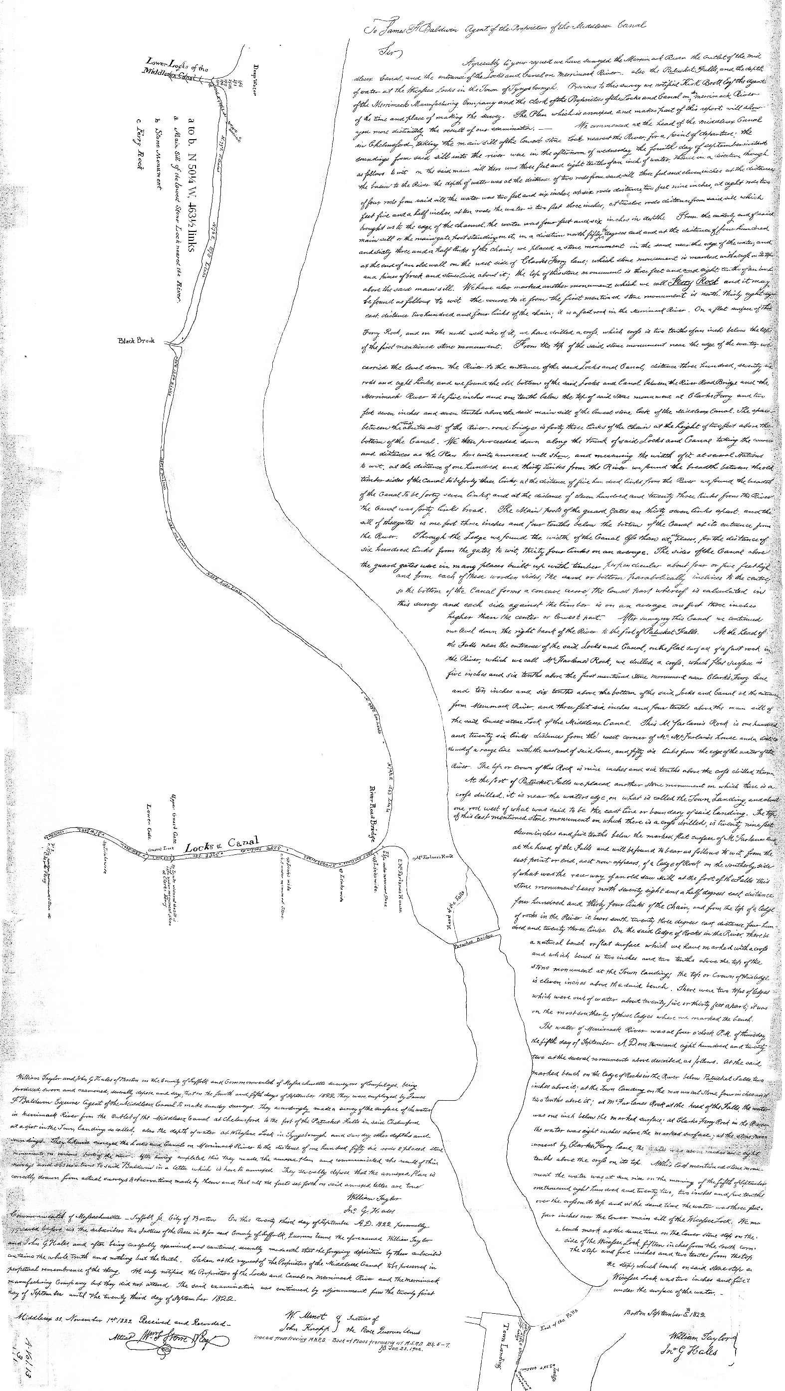
Of all the marks used in the survey, only one remains visible after nearly 200 years, a Ledge of Rocks at the foot of the falls, described in the 1822 survey report as follows:
At the foot of Patucket Falls we placed another stone monument on which there is a cross drilled. It is near the water’s edge, on what is called the Town Landing, and about one rod west of what was said to be the east line or boundary of said Landing. The top of this last mentioned stone monument on which there is a cross drilled, is twenty nine feet eleven inches and five tenths below the marked flat surface of McFarlane’s Rock at the head of the Falls and will be found to bear as follows to wit, from the east point or end, as it now appears, of a Ledge of Rock on the southerly side of what was the race way of an old Saw Mill at the foot of the Falls this stone monument bears north seventy eight and a half degrees east, distance four hundred and thirty four Links of the Chain, [286.5’] and from the top of a Ledge of rocks in the River it bears south twenty three degrees east, distance four hundred and twenty three Links [279’]. On the said Ledge of Rocks in the River, there is a natural bench or flat surface which we have marked with a cross and which bench is two inches and two tenths above the top of the stone monument at the Town Landing; the top or Crown of this ledge is eleven inches above the said bench. There were two tops of Ledges which were out of water about twenty five or thirty feet apart; it was on the most southerly of these Ledges where we marked the bench.
The Ledge of Rocks is located just downriver of the outlet channel of the Eldred Field Hydroelectric Plant as shown in the figure below.
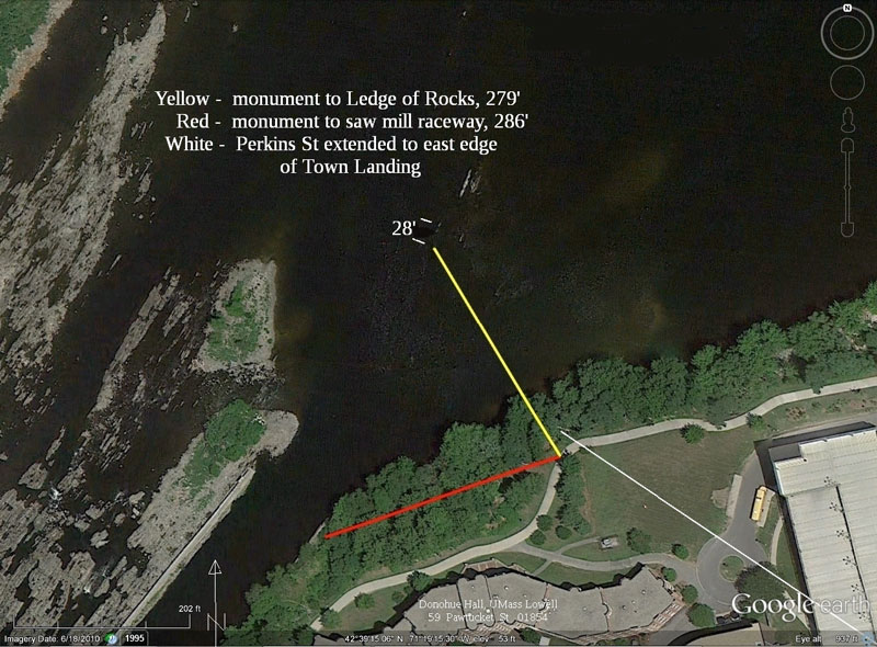
Figure 1. Town Landing, Foot of Falls to River Monument
The location of the east boundary of the town landing is based on the assumption that the street laid out in George Baldwin’s 1825 plan of Patucket can be identified with 2013’s Perkins St.
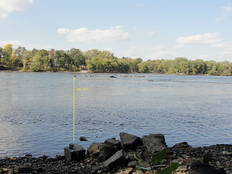
Figure 2. Ledge of Rocks, 220' from the river shore
The “natural bench or flat surface” marked with a cross was not present on the most southerly of the two tops twenty-five or thirty feet apart. From the close-up photo, below, of the southerly rock when being measured by a straightedge and combination square set at eleven inches, it seems the upriver prow where the drilled cross might have been located has worn away since 1822.
The “top or crown” is at elevation 54.29’ (NGVD29) as surveyed in 2013, based on a temporary benchmark with elevation 82.78. (See Cabot St. Area Sewer Separation, Project 3057, May 2010, Lowell Regional Wastewater Utility, sheet 4, TBM 281.) The top as measured in the 1822 survey is 25.33’ below that survey’s point of departure, the “main sill of the lowest stone lock” of the Middlesex Canal at the Merrimack River.
Based on George Baldwin’s 1830 profile of the canal, the sill is at elevation 79.41, and the top, 25.33’ lower, would be at 54.08, lower by 0.21’ than the 2013 direct measurement.
The vertical difference of 0.21’ between 2013 and 1830 supports the conclusion that the rock found by the horizontal description in the 1822 survey report is in fact the southerly top of the Ledge of Rocks, notwithstanding the lack of a drilled cross. Also, the difference supports the validity of the adjustment, Baldwin 1830 – 3.84 = NGVD29, described in Towpath Topics, Sept 2013, “The 1825 Iron Bolt”, p. 10.
Figure 3. Upriver Prow of Marked Site, close-up of measurement
Notes
1. The rock is made of an igneous mineral, different from the layered rock ledges around it, which might account for it having had a distinctive “natural bench or flat surface”.
2. Temporary benchmark 281 was checked against the Stormceptor rim and manhole 57482. TBM 280 is 0.17’ lower than shown on sheet 4 based on TBM 281.
3. Two one-way survey runs were done in October 2013, giving top elevations of 78.58 and 80.36. A third, partial run found an error. After Figure 3, Upriver Prow of Marked Site, close-up of measurement correction, 79.62 is used, but a round-trip, TBM 281 to the Ledge of Rock and back, hasn’t been done.
SHIPPING DOCUMENTS
A compilation of the information contents thereof
by Bill Gerber
You can now access a compilation of the content of all of the individual trip related shipping documents from the archived records of the Middlesex Canal Company. Too large to print out in Towpath Topics, the file itself can be downloaded from http://middlesexcanal.org/docs/passports.pdf. You should be able to open the file in any browser, though you may wish to open in directly in Acrobat or another PDF viewer. You may also wish to adjust the magnification until the text is large enough to read.
Consider this a “preliminary version”, undoubtedly the list still contains a number of uncertainties and errors that will likely take a long time to resolve, if they ever are. For example, not uncommonly some of the handwritten entries were difficult to interpret - some of these were abbreviations, the meaning of which was not determined; in other cases where handwriting could not be read, a dash or something comparable was inserted simply to mark space for it.
To construct this file, information was extracted from the entire set of 225 shipping documents in the archives at the Mogan Center. The type of document from which each line of data was obtained is indicated in the leftmost column. These included: Passports (Pp); Passport Summaries (Pp Sum); Bills of Lading (BoL); and Certificates of Cargos (Cert Cargo).
To enable the information to be arrayed chronologically (by a computer sort), dates were written in one continuous ‘block’ as - year, month and day (e.g., 1805-04-20, but without the dashes). The list was further hand-sorted using the sequential numbers of the passports, etc. issued in any one year.
Most, but not all documents also have a sequential number - in most years a new series was started in the spring with the opening of the shipping season.
Specific observations about the file - (and please send me your’s, too.)
Typically, it appears that something on the order of 300+ boats went down the canal each year; thus, although the file provides some useful insights, the entire set is less than one-year’s traffic, and thus it is too small to give us a good representation of all of the types of cargos shipped.
The file contains a fair amount of information about some shipping years, not so much about others, and none at all about many. For example, there is no coverage whatsoever for the years that the Merrimack Boating Company operated, nor are there entries for the Union Boating Company.
Although there are a few records from the early days of the canal, there is a major “hole” in the data from 1809 through 1826; we simply have no records for any of these years.
None of the cargos that remained on the river or passed through the Pawtucket Canal, bound for Newburyport or sites en route, are accounted for. Likely these would include rafts of timber, and such things as the bricks, stone and timber used to build the early textile mills; and later, the materials to build the various railroads that then competed with the canal.
There is little or no information about the shipping of materials that would have been used to construct the mills in Nashua, Manchester, etc. Such shipments likely originated from up-river and terminated well upstream of the Middlesex Canal.
Most of the documents cited describe the contents of shipments made down the canal, i.e., from Chelmsford to Charlestown and Boston.
Only a few of the records are for cargos that came up the canal. These latter records consist of: a few boats carrying iron ore, bound for Chelmsford (likely to the foundry in North Chelmsford), which entered the canal from the Concord River at Billerica Mills; a few shipments from Boston Landing to the Bent & Bush Hat Factory in Chelmsford; and a few shipments from Landing #1 to Landing #8 (i.e., the Landings at Charlestown and Chelmsford, respectively.
Use of the term “Boston Landing” indicates that the cargo originate from or terminated on the Boston side of the Charles River. Likely these refer to shipments to and from the MCC’s Alms House Wharf.
There are far fewer timber rafts noted than I would have expected to see; ditto boatloads of granite and bricks. (OTOH, there are large gaps in the information available and the gaps bridge some of the more likely times when such loads would have passed through.)
There is very little coverage that might relate to the shipping of granite, used in the construction of many public buildings in Boston and Cambridge during the life of the canal. For example, ‘Chelmsford Granite’, brought down the canal, was used in the construction of the Charlestown Prison, the Bulfinch Building at Mass General Hospital, University Hall at Harvard, and the porticos of the Faneuil Hall Marketplace. Regarding this latter building, the foundation is of Quincy granite, but the walls were constructed of Concord (NH) Granite, also brought down the canal.
In 1834/35 there were many shipments of bog ore up the canal. In his book “Concord River”, Laurence Richardson noted that ore was obtained from along the Assabet River (see TT- 4/2011, footnote #10), thus it would have traveled down that and the Concord Rivers, passed through the floating towpath (via a drawbridge in the floating towpath) and been admitted into the canal at Billerica Mills. At Chelmsford, ore boats would have locked down into the Merrimack River and traveled upstream to the iron furnace at North Chelmsford.
There is no information about the shipping of raw cotton from Boston to Lowell - neither the raw material nor the finished textiles. These would have been major cargos from the opening of Lowell’s textile mills until the coming of the railroad, (ca 1823 to 1835. See C. Roberts: The Middlesex Canal, p-152. It would have been this additional revenue that enabled extensive rebuilding of the canal in the late 1820s.) This void extends to the mills in Nashua and Manchester as well.
The left side of each entry tends to relate to the boat, its owner and its operator, where it came from and where it was going. The right side tends to relate to the owner of the cargo, what the cargo consisted of, weights (etc.) and how much would be charged. (Much liberty was taken with the formatting to accommodate the many different ways this information was recorded.)
Where the term “canal boat” is used, this appears to refer to a boat belonging to the Middlesex Canal Company (MCC), as compared to boats belonging to individual shippers. Thus it may be that the MCC maintained a number of boats which they leased or rented to the public (however, caution, I’ve not seen any reference to this in any other documentation).
There are many more “masters” (boat skippers) than I expected. OTOH, some names recur fairly often.
| BUSINESS ON CANAL IN YEAR 1805 | |
| Wood, 3997 cords weighing | 5000 tons |
| Oak Timber, 422 tons measure | 422 |
| Pine do, 1405 tons measure | 1200 |
| Oak Plank, board measure. 187,200 | 374 |
| Pine Planck, 912 thousand, board measure, weighing | 1100 |
| Stone | 310 |
| Cyder, 3242 barrels | 405 |
| Ashes, 33 barrels | 8 |
| 1848 empty hogsheads | 42 |
| 2196 empty barrels | 12 |
| 154 half barrels | 2 |
| 360 kegs | 3 |
| 36,920 hogsheads hoops | 70 |
| 11 tons, 13 hundred & 23 pounds of hoops | 11-3/4 |
| Shocks | 23-3/4 |
| Hoop poles | 1-3/4 |
| Grain. 155 bushels | 3-1/2 |
| Apples, 493 bushels | 5 |
| Other articles | 20-1/2 |
| Sumack | 2 |
| 3750 Clapboards | 3-3/4 |
| 4569 Staves | 5 |
| 147 thousand Shingles | 29 |
| 77 barrels of Beef | 9 |
| 237 bushels Flax Seed | 6 |
| Ranging Timber | 5 |
| 1800 Rails | 3 |
| Goods carried | 308-1/2 |
| Total | 9405 tons |
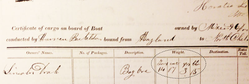
A number of documents contain a four-column entry which relates to the weight of the load and/or the amount to be charged. In most cases these refer to Tons, Hundredweight (Cwt), Quarters (qtrs, of hundredweight) and Pounds (lbs), as shown within the oval in the figure below. However, it is not clear which system of measurements was in use at the time the entry was made - e.g., do the entries refer to US long tons, or short tons, or perhaps to Imperial tons? And, over the decades, this form of entry may not have been used consistently; i.e., there is some uncertainty that all such four column entries have the same meaning in the early years of the canal, as compared to their meaning in the later years.
In the remarks section (the last column) there’s a mix of comments that I found on some of the documents, as well as comments in brackets that I made. (I think I was pretty consistent in using brackets for my comments, I hope so!)
If possible I would like to add to the file. If you know of sources for any other such shipping documents, I’d appreciate it if you’d “point me” to them.
There are several other sources by which this file might be expanded. The Manchester Historical Association possesses several ledgers which detail much traffic through the Amoskeag Canal in the early 1840s. (One big item was “Chestnut Sleepers”, i.e. the ties used to construct the track for the Nashua-Concord RR, which opened in 1842.) Also, the NH Historical Society possesses one ledger which details traffic that passed through the Hooksett Canal. (If anyone cares to volunteer some time and treasure, these offer considerable potential for building on this base. If not, maybe I’ll get to them, too, some day.) I know of several documents in a private collection, perhaps I can gain access to these someday. And there are a few yearly summaries, such as the one shown opposite, the information from which might, somehow, be included.
I hope that this will be of some use to you and to any others who are researching related matters.
THE UNION CANAL
by Bill Gerber
Soon after I began editing Towpath Topics, I included information about the activities of other canal-related organizations in the Calendar section. My purpose was to encourage MCA members to ‘sally forth’ to see what others are doing. I don’t know how much interaction there may be, now, but in decades past there was a fair amount of it, and others came here as well.
I recently attended a field trip to the Union Canal (UC) sponsored by the Pennsylvania Canal Society. Organization of this trip was typical of how most other societies/associations present their canals, as part of their efforts to preserve them and to educate their public, so perhaps it will be helpful to describe the trip.
Authorized in 1791, the intent of the UC was to link the Susquehanna River, just south of Harrisburg, to the Schuylkill Canal near Reading, to divert river traffic to the port of Philadelphia, instead of having it travel to Baltimore, which was reachable by continuing on down the river and around the upper reaches of Chesapeake Bay.
About the Union Canal
The UC extended roughly along a line between Middletown and Reading (PA), passing just to the north of Lebanon. When finally completed, it’s main channel was 81 miles long and incorporated 93 locks, two weighlocks, four aqueducts and a canal tunnel (a rare feature), to overcome an elevation of 503 feet. A feeder canal added 22 miles and 14 locks to the total system length and features.1
There are historical links between the Union and Schuylkill Canals, in Pennsylvania, and the Middlesex Canal here in Massachusetts. Prior to the start of construction, the Proprietors of the Middlesex Canal were not confident of the surveys they had conducted of potential routes for their canal. In the summer of 1794 they ‘borrowed’ the services of the English canal engineer William Weston to conduct surveys of two such routes.2 Weston had been hired by Robert Morris (sometimes known as the “financier of the American Revolution”) to oversee construction of the two aforementioned Pennsylvania canals.
As part of his efforts, Weston radically improved American surveying technology by introducing the ‘Y-level’ and ‘station rod’. The ‘Y-level’ was an optical instrument, developed and produced by Mr. Troughton, Mathematical Instrument Maker, in London, England, which, coupled with a station rod, containing a vertical scale readable through the ‘Y-level’, enabled accurate elevation measurements to be made.3 And indeed, serious elevation errors were subsequently found in the earlier Middlesex Canal surveys.
Cruel financial limitations intervened; in 1794 the financiers of the Union and Schuylkill Canal Company ran out of money and construction was suspended. Efforts to raise funds by such means as lotteries were not very successful and work on the UC did not resume until about 1822. When it did, the reconstituted UC Company selected Loammi Baldwin, son of the ‘Supervisor of Construction’ for the Middlesex Canal (which opened two decades earlier), as its chief engineer. However, Baldwin held the job and title for only about a year. He resigned in 1823 and was replaced by Canvas White (chief engineer for the Erie Canal), who saw the construction through to completion in 1828. The reasons for Baldwin’s departure seems to have been disagreements with the UC managers over the route of the canal at summit level, near Lebanon, also that he wanted to build locks larger than the 8-1/2 x 75 foot locks desired by the Board.4 (Small even when compared with the diminutive M’sex Canal.)
For whatever consolation it may have been, history proved Baldwin correct. The UC was never very successful, the principal reason being that its locks were too small to accommodate the larger boats that were shortly to come into use on the Pennsylvania Mainline Canal, to the west, and the Schuylkill (coal) Canal to the east, thus it was never able to serve as the link envisioned by its initial creators. Enlargement of the UC, in the mid-1850s, were ‘too little and too late’; both competition and technology had passed it by.
At least one PCS historian thinks that the UC managers may have had a sinister motive for constraining the size of their locks. As on our M’sex Canal, some of the owners and investors were also engaged in shipping goods, e.g., coal and iron ore, and may have wanted to eliminate competition from other shipping companies.5 By keeping the locks small, the larger boats of the other companies could not transit the UC, but their small boats could go wherever they pleased on adjacent canals.
References:
1 Stuart Campbell; Union Canal Locks; Historic American Engineering Record, HAER No. PA-66, 1976. Also Pennsylvania’s Union Canal, marked WM 8/81, 3 pages plus attached drawings; PCS Field Trip handout.
2 Christopher Roberts, “The Middlesex Canal, 1793-1860”; Cambridge, Harvard Univ. Press, 1938; p 55.
4 Stuart Campbell; Union Canal Locks; Historic American Engineering Record, HAER No. PA-66, 1976, p-1.
5 Personal conversation between the author and Douglas Logan of Phoenixville, PA.
About the trip
Officially, the field trip began late on a Friday afternoon with an early registration at a hotel in Lebanon, PA. Dinner was “on your own”, after which there was an assembly in a hotel meeting room where Jim Schucker, a Union Canal historian, gave a presentation on the history of the Union Canal.
The next morning we boarded a bus to begin our all-day tour of the UC. In contrast to the M’sex Canal, where so few of the original structures can be found, the tour leaders have ferreted out many Union Canal related structures - e.g., the remains of locks, aqueducts, lock keepers’ houses, and the home of the canal CEO. Figure 1, shown below, is of the remains of lock 21W at the western end of the UC.
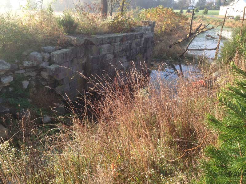
Figure 1. Remains of Union Canal Lock 21W
Around mid-morning we visited the canal tunnel, a unique feature of the UC. Initially about 730 feet long, now a bit shorter, it was cut through a hill that was much too high to excavate. The tunnel is of stone arch construction, 18 feet wide and 15 feet high. The width of the tunnel is sufficient for the wider boats of the enlarged UC to negotiate. Boats were poled through, there being no towpath for the tow animals to walk on; the animals were led over the hill to rejoin their boat on the opposite side.
Today, a park has been set up to promote public access to and knowledge of the tunnel and the canal of which it was a part. Figure 2 shows the tunnel’s eastern portal.
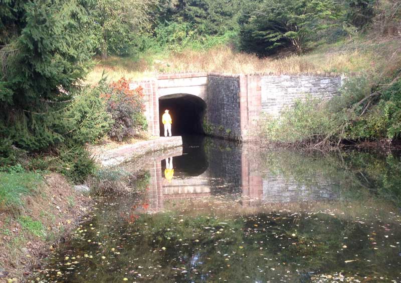
Figure 2. Union Canal tunnel, Eastern Portal
Until recently, it was possible to take a guided boat ride through the tunnel; but alas, regulatory authority now requires that the boat operators be US Coast Guard certified. It doesn’t seem to matter that, to negotiate the tunnel, the need for navigational skills is less than trivial, or that the canal is sufficiently shallow that anyone falling overboard could probably wade out! Regrettably, it is not clear when, or even if, the boat tours will be reinstated.
Now situated in a community park where we stopped for lunch, (and a cold lunch on a cold and windy day it was), Figure 3 is the enlarged and restored UC lock 8E, located toward the eastern end of the canal.
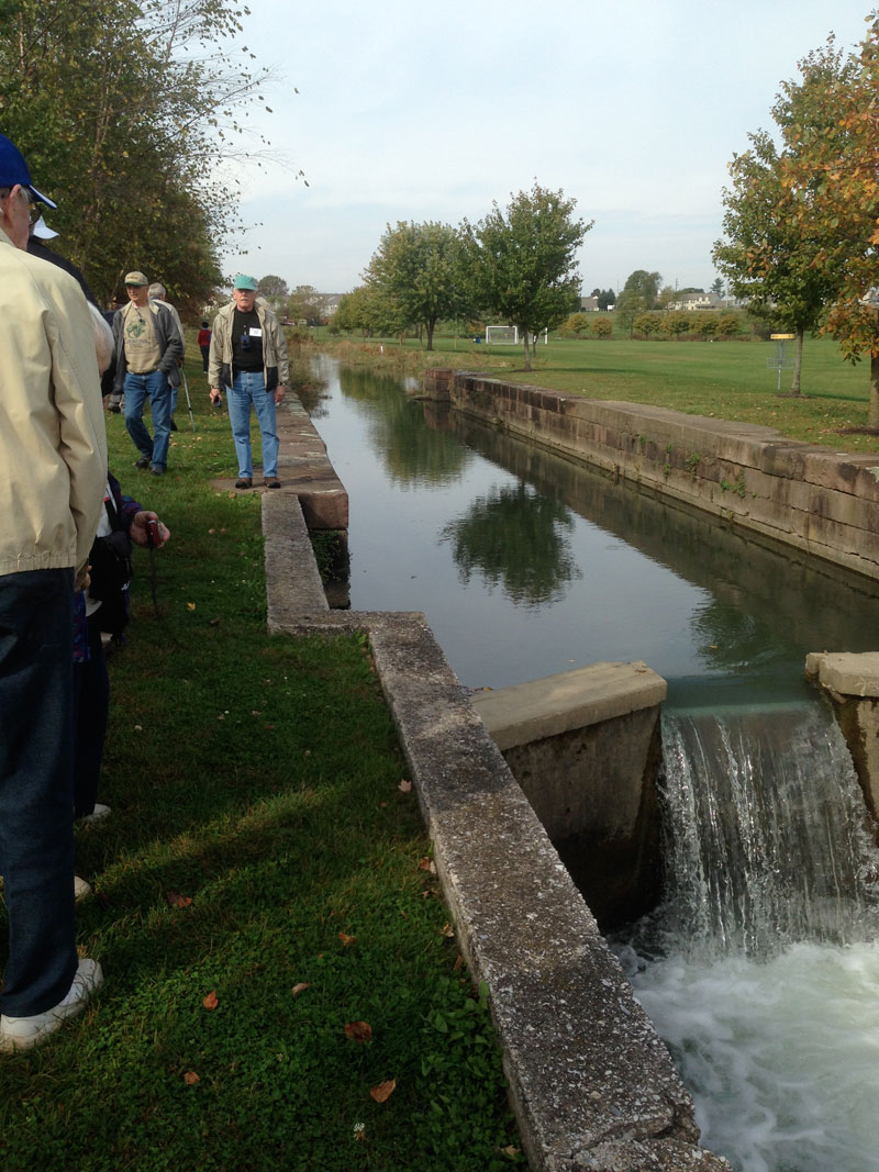
Figure 3. Union Canal Lock 8E
The evening dinner was a catered affair, reasonably well done; after which Jim Schucker returned to provide, among several topics, a fairly detailed account of the construction, enlargement and restoration of the tunnel.
Several activities were scheduled for Sunday, leading off with a PCS Board of Directors meeting. To the best of my knowledge, of the scheduled events, only the Board meeting took place. However, a guided tour of the Hiester Museum, north of Reading (near the airport) was substituted, with PCS President Glen Wenrich serving as tour guide. This museum has been ‘Glen’s baby’ for decades and so the tour was superb. I should also note that the Hiester is one of the best canal museums I’ve seen; I recommend it to anyone who travels within 100 miles of Reading, PA!
About the Museum
Shown below are photos of several of the items exhibited.
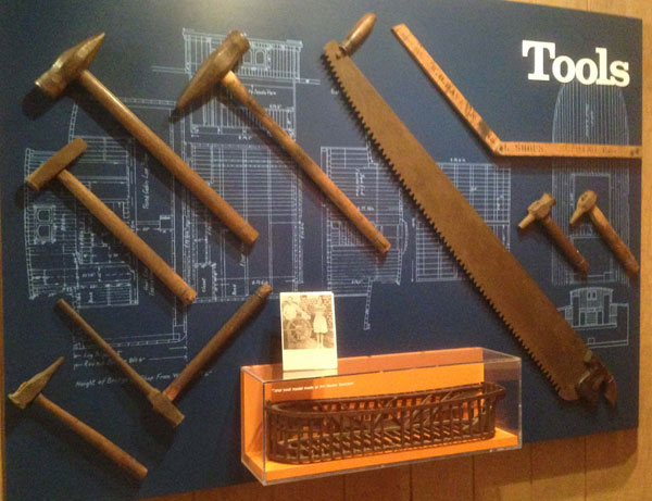
Figure 4. Boat Building Tools, and Canal Boat Keel & Rib Model
Figure 4 is a display of tools used in building the boats that plied the several eastern Pennsylvania, New Jersey and New York coal canals. Also shown is a model of the rib construction of some of the boats.
Figure 5 below is a full-sized, open-sided replica of a canal boat cabin, not very big and quite spartan, which provided living space (bedroom, dining room and galley), for a “canaler family” - i.e., dad, mom and some number of children, all of whom would have been involved in operating the boat.
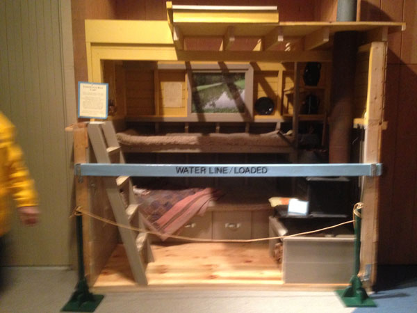
Figure 5. Full-sized Model of Canal Boat Living Quarters
In some cases, additional cabin spaces were built in other parts of the boat, e.g., the bow, where living space wouldn’t encroach much on the available cargo space. This alternate space might be occupied by some of the older children.
Figure 6 shows large scale models of the type of sectional boats that were used on some of the coal canals. These used a unique steering device, shown in Figure 7. Controlled from the bow of the aft boat, the ships-wheel would adjust chain tension between the boats so as to cause the aft-boat to served as the rudder for the lead boat.
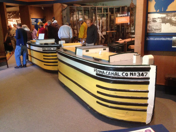
Figure 6. Models, Penna. Canal Company Sectional Boats
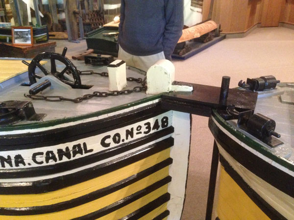
Figure 7. Sectional Boat Steering Mechanism (not properly rigged)
Figures 8 a&b are rack and pinion mechanisms that were used to raise and lower the wickets in the UC locks; 9a is the lifting mechanism and 9b is the rack-gear with the remnant of a wicket at the other end of the extension arm between them.
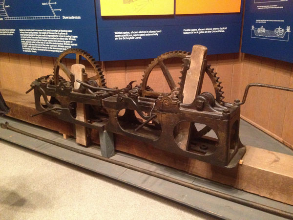
Figures 8 a&b. Lock Wicket Lifting and Lowering Mechanisms
Loammi Baldwin (Sr.) apparently incorporated similar mechanisms on the Middlesex Canal, to admit or close off water to the bypass channels in the locks of the Merrimack flight, the first locks built on the M’sex and possibly the only ones to use bypass channels. Several historical documents mention the problems Baldwin had finding a foundry that could cast and shape the respective gears with sufficient precision, uniformity and stability to function properly. And Judge Samuel Hadley noted how, as a young lad, he slid through the bypass channels from one lock to the next.
Figure 9 is an enlarged and annotated photo - of a Weigh-Station, where the weight of the cargo carried by each passing boat was measured to determine the toll to be charged.
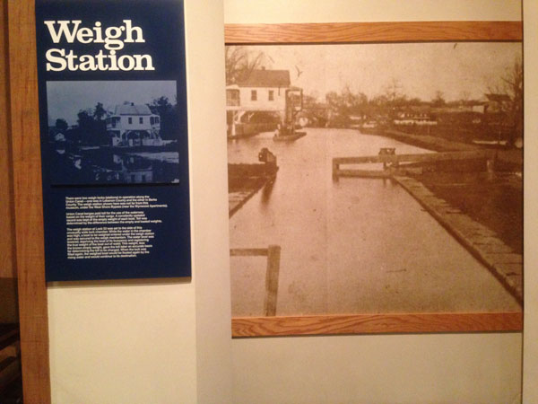
Figure 9. Union Canal Weigh-Lock
Figure 10 is also an enlarged photo - of a timber-crib dam, a type commonly used on many of our rivers and historical canals, often to create a well defined elevation difference between two levels.
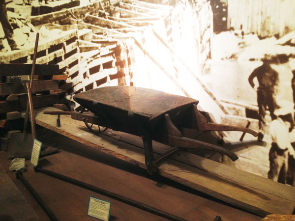
Figure 10. Timber Crib Dam and wheelbarrow
Such dams were built at the various bypass canal sites along the Merrimack River (see TT- 1/2009, “Canals of the Merrimack”).
In the foreground of Figure 10 there is a wheelbarrow similar to the type that was used in building the Middlesex Canal. It is quite likely that this style of wheelbarrow was introduced into both Pennsylvania and Massachusetts by the English canal engineer William Weston (see TT-10/2008; “Early Tools … “).
Glen was quite proud of an item recently acquired and put on display; this was a large lantern, called a “Nighthawker”, that was affixed to the deck of canal boats, near the bow, to enable them to run at night. These were used on a number of canals including the Lehigh & Delaware. Apparently only a few such lanterns have survived to the present. Figure 11 is a photo of a similar item.
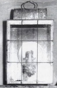
Figure 11. “Nighthawker” Canal Boat Lantern
And finally, Figure 12 is a graphic on a clear backing that shows the relative size of the canals that were built in Pennsylvania, and of the boats that operated on them.
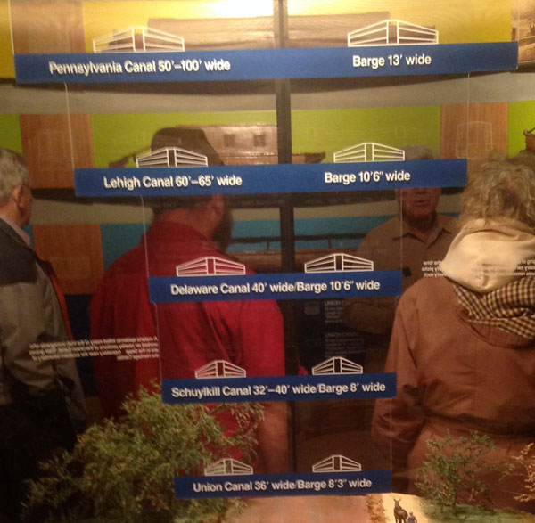
Figure 12. Graphic showing the size of Pennsylvania’s coal canals and the boats employed on them
And if an excellent canal museum isn’t enough to stimulate your curiosity, an entire wagon manufactory, the Gruber Wagon Works, was recently moved into the surrounding park area. One of the wagon works’s claims to fame is that it is the only such facility surviving in the nation. Another claim is that a tour of it is absolutely fascinating; I fully agree.
ARCHAEOLOGY
by Bill Gerber
Assuming that you have an interest in history (a reasonable assumption given that you are reading this newsletter and likely are a member or proprietor of the MCA), are you also interested in archaeology?
Beginning in the late 1990s, Channel 4 TV in England ran a series entitled “Time Team”, in which they conducted many short archaeological digs, and/or tagged along with, and often augmented, the efforts of others. Over the years they produced about 20-dozen nearly hour-long programs covering topics ranging from prehistoric to fairly recent. You can find a more detailed description at http://en.wikipedia.org/wiki/Time_Team, and a list of the programs at http://en.wikipedia.org/wiki/List_of_Time_Team_episodes, many of which are now available from You-Tube, e.g., www.youtube.com/watch?v=u4AwKq2I8ss, to pick one at random.
More recently, the series inspired “Time Team America”, several programs of which have aired on PBS stations; the site http://en.wikipedia.org/wiki/Time_Team_America provides more information and a listing of available programs. (Yes, I know of several canal-related sites that I’d like to explore, but I’ll save discussion of those for future consideration.) Overall, the “Time Team” series offers a wealth of entertainment and quality education to occupy your attention on some cold winter nights.
MISCELLANY
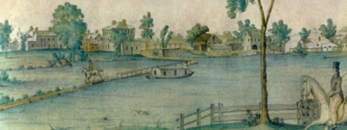
Nameplate - Excerpt from a watercolor painted by Jabez Ward Barton, ca. 1825, entitled “View from William Rogers House”. Shown, looking west, may be the packet boat George Washington being towed across the Concord River from the Floating Towpath at North Billerica.
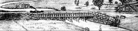
Back Page - Excerpt from an August,1818, drawing (artist unknown) of the Steam Towboat Merrimack crossing the original (pre-1829) Medford Aqueduct, probably on its way to service on the Merrimack River.
Estate Planning - To those of you who are making your final arrangements, please remember the Middlesex Canal Association. Your help is vital to our future. Thank you for considering us.
Museum & Reardon Room Rental - The facility is available at very reasonable rates for private affairs, and for non-profit organizations’ meetings. The conference room holds up to 60 people and includes access to a kitchen and rest rooms. For details and additional information please contact the museum at 978-670-2740.
Web Site - As you may have noted in the nameplate, www.middlesexcanal.org is the URL for the Middlesex Canal Association’s web site. Our webmaster, Robert Winters, keeps the site up to date, thus events and sometimes articles and other information will sometimes appear there before we can get it to you through Towpath Topics. Please do check the site from time to time for new entries. Also, the site now contains a valuable repository of historical information, all of the back issues of TT, and an index to all of the articles contained therein, can now be found there at http://middlesexcanal.org/towpath.
Back Issues - Fifty years of back issues of Towpath Topics, together with an index to the content of all issues, are also available from our web site at middlesexcanal.org/towpath. These are an excellent resource for anyone who wishes to learn more about the canal and should be particularly useful for historic researchers.
Canal Boat Rides - The American Canal Society maintains an annotated list of more than two-dozen canal boat ride concessions that operate at various places in the eastern USA and parts of Canada. The list can be found at www.americancanals.org/Canal_Boats/Canal_Boats.htm. Go take a boat ride!
Canal Game and Puzzle - The National Canal Museum provides a canal related game and a puzzle on their web site www.canals.org/funandgames. In the Boat Captain’s Game - Can you run a canal shipping business successfully ‘in the black’? And the Canal Lock Puzzle - would you know how to construct a canal lock and make it work? Give them a try.
Towpath Topics is edited and published by Bill Gerber and Robert Winters.
Corrections, contributions, and ideas for future issues are always welcome.