
Middlesex Canal Association P.O. Box 333 Billerica, Massachusetts 01821
www.middlesexcanal.org
| Volume 55 No. 2 | January 2017 |
Please mark your calendars
MCA Sponsored Events
Winter Meeting, 1pm, Sunday, March 5, 2017 (postponed from Feb 12)
Chuck Mower
Brick Making along the Merrimack
30th Annual New England Industrial Archeology Conference
March 4, 2017, Clark University, Worcester, MA
http//:nec-sia.org
Bicycle Tour South, 10:44am, Saturday, April 1, 2017
Easter Sunday, April 16, 2017 Museum Closed
Spring Walk, 1:30pm, Sunday, April 23, 2017
Billerica to Chelmsford
Spring Meeting, 1pm, Sunday, April 30, 2017
Susan Clarke
50th Anniversary of the publication of The Limner’s Daughter
15th Bicycle Tour North, 9am, Sunday, October 1, 2017
Fall Walk, 1:30am, Sunday, October 15, 2017
Billerica Museum South
Fall Meeting, 1pm, Sunday, October 22, 2017
Speaker TBA
The Visitor/Center Museum is open Saturday and Sunday, noon – 4pm, except on holidays.
The Board of Directors meets the 1st Wednesday of each month, 3:30-5:30pm, except July and August.
TABLE OF CONTENTS
Events and Directions to MCA Museum and Visitor Center
Vice President’s Message - by Traci Jansen
The Tide Mill Institute highlights The Boston Mill Pond - by Betty M. Bigwood & Thomas H. Dahill
The Merrimack Flight, and Baldwin’s “Hydraulic Machine” - by Bill Gerber
Winchester Culvert Location - by J. Jeremiah Breen
Thomas Jefferson, Canal, and Waterways - by Dan Van Haften, Submitted by Thomas Raphael
At the 2016 Presidential Election, Billerica Adopts the Community Preservation Act - by Marlies Henderson
Serendipity Sets the Pace for other Corporations - by Marlies Henderson
Billerica Historical Commission Community Grant Report: High Street Middlesex Canal Wayside Marker Re-dedication - by Alec Ingraham
A Probable Scene on the Middlesex Canal and Merrimack River - by Howard Winkler
Editors’ Note
As we start to put together this last issue of 2016 it has already begun to feel like winter, even though we have not officially passed the December 21st solstice. Yet by the time you receive your version (computer or paper) it will be a New Year and winter will have descended on us again. We hope all of your holiday memories will be happy ones.
A pattern has been developing in our editorship where we very slowly assemble the articles as they trickle in, and we think this issue is probably going to be “slim.” Then, as the deadline nears more and more articles are submitted, and the issue is chock-full of interesting items by the time the deadline has passed. This issue is no different, there are many interesting, informative articles and there should be something for everyone.
First up is a letter from MCA Vice-President Traci Jansen, and we hope it will be the first of many letters. There are articles by Bill Gerber, J Jeremiah Breen and Dan Van Haften (by way of Tom Raphael) that add to our canal knowledge. Marlies Henderson and Betty Bigwood have reported on local events and activities of members. And finally, we have reminiscences by Howard Winkler of a painting that inspired him on a family vacation.
Please remember that we are always looking for new material connected to the events, places or people related to the Middlesex Canal that we can include in future issues.
Happy New Year!
—— Deb, Alec, and Robert
Events and Directions to Museum
Winter Meeting: On February 12, 2017 at 1:00pm the Middlesex Canal Association will hold a public meeting at the Middlesex Canal Museum and Visitor Center, 71 Faulkner Street, North Billerica, MA. The featured speaker will be Charles H. (Chuck) Mower. Mr. Mower is a master craftsman, teacher, community activist, and historian from Merrimack, NH. His topic will be Brick Making along the Merrimack. Blessed (and cursed) with a thick layer of glacial clay, communities along the Merrimack River established brickyards to satisfy the insatiable construction needs of nearby textile mills and related industries, then sent their products to market on ‘fleets’ of canal boats*. Come to hear the who, how, when, and where of local brick making.
* From Towpath Topics, #55-1, 09/2016, “ Luther A. Roby, Boatman”
* Concord, Piscataquog, Litchfield, and Nashua each had its line of boats, making in the aggregate quite a little fleet. The Litchfield town history claims that their community operated twenty boats.
Bicycle Tour South: On Saturday, April 1, 2017, Dick Bauer and Bill Kuttner will lead the a bicycle tour of the Middlesex Canal. The ride will begin at the Lowell MBTA train station at 10:44am when the 10:00am train arrives from Boston. Those cyclists, who plan to board the 8:00am Lowell train at North Station, will have time to spend in Lowell and are invited to join the leaders at the Owl Diner, which is listed on the National Register of Historic Places. This is an MCA sponsored event and helmets are required. Participants may join the ride at any point along the route. For more detail please visit www.middlesexcanal.org.
Spring Walk: This walk is jointly listed as a local walk of the Boston Chapter of the Appalachian Mountain Club and the Middlesex Canal Association. On April 23, 2017, those planning to join the walk should meet at 1:30pm at the Middlesex Canal Museum and Visitor Center on 71 Faulkner Street in North Billerica. The 2½ hour walk will cover part of the Merrimack River branch of the canal in Billerica and Chelmsford, over about 3 to 4 miles of generally wooded terrain. Sites to visit will include the recently restored guard lock, the anchor stone for the floating towpath that bridged the Concord River, and many stretches of the watered canal. The walk will be led by Robert Winters and Marlies Henderson. For more information please visit www.middlesexcanal.org.
Directions to Middlesex Canal Museum and Visitors’ Center
By Car: From Rte. 128/95 Take Route 3 toward Nashua, to Exit 28 “Treble Cove Road, North Billerica, Carlisle”. At the end of the ramp, turn left onto Treble Cove Road toward North Billerica. At about ¾ mile, bear left at the fork. After another ¾ mile, at the traffic light, cross straight over Route 3A (Boston Road). Go about ¼ mile to a 3 way-fork; take the middle road (Talbot Avenue) which will put St Andrew’s Church on your left. Go ¼ mile and bear right onto Old Elm Street. Go about ¼ mile to the falls, where Old Elm Street becomes Faulkner Street; the Museum is on your left and you can park across the street on your right, just beyond the falls. From I-495 Take Exit 37, North Billerica, south two miles to the stop sign at Mt. Pleasant Street, turn right, then bear right at the Y, go 700’ and turn left into the parking lot. The Museum is across the street (Faulkner Street). By Train: The Lowell Commuter line runs between Lowell and Boston’s North Station. From the station side of the tracks at North Billerica, the Museum is a 3-minute walk down Station Street and Faulkner Street on the right side.
A Vice President’s Message
Winter Greetings
I was introduced to the Middlesex Canal Association over ten years ago when the Education Committee approached the Wilmington Public Schools with a third grade curriculum about the amazing Middlesex Canal. Betty Bigwood and some others invited a group of teachers to a luncheon at the Museum. The afternoon was so informative and the hosts were so charming that I was hooked! Over the years I continue to be impressed by the Board of Directors’ enthusiasm for the history of the Canal and I find myself more passionate about local history than I ever thought possible. Every member brings a special talent to the Association and I appreciate the way we work as a team to inform the community, manage the Museum, and preserve history.
Now, it is a thrill for me to see so many people and groups enjoy the Middlesex Canal Museum and Visitor Center as I have. This past year we’ve hosted school groups of teachers and students, Girl Scouts and Boy Scouts, local community groups, and politicians. We’ve been part of Archeology Month and Riverfest and our lectures and special meetings attract people from all around. Weekend visitors continue to show interest in our exhibits and Reardon Room rentals bring in people that are in awe of our space.
While I spend my school days working with teachers and students to integrate technology in education, I think about the engineering of the Middlesex Canal and the innovation and progress of 19th century America. It is a thrill to be part of the Middlesex Canal Association and to honor the history and impact of this incredible project.
It is true that my primary focus is with our Education Program, but I am also interested in fostering partnerships with neighboring historical societies and it is most important that we grow our membership! Join us!
Traci Jansen
Vice President
Middlesex Canal Association
The Tide Mills Institute Highlights The Boston Mill Pond
by Betty M. Bigwood & Thomas H. Dahill
The Tide Mills Institute’s 12th annual conference was held on November 12, 2016 at the Waterwork’s Museum in Chestnut Hill, MA. It was an all-day affair. The Boston Mill Pond was the genesis of the Boston Canal and Tom’s painting “The Canal that Bisected Boston”.
I picked up Tom at 7:15am to give him ample time to set up a display. This consisted of his maquette (An initial smaller version of the final painting presented to Trinity Financial for approval.) and an enlargement of the final painting. One hundred handouts, copies of the painting, were well received.
The Waterworks Museum is a handsome building designed in Richardsonian Romanesque style by architects Arthur H. Vinal and Edmund M. Wheelright. The pumps provided water for the area until the Quabbin Reservoir was brought in in the 1970’s but is still kept available for back up if needed. A cold wind across the reservoir rushed our way into the building. We had a tour of the premises.
Bud Warren, President of the TMI, welcomed the group. I had attended several meetings in the past covering the power generated by water to provide energy in historic, present and future arenas.
The first speaker was author Jonathan White. A book he has written on tides around the world is due in book stores in February. The timing was perfect as we were in the midst of perigee (closest distance of the moon from the earth in its oval orbit) and this supermoon is larger than it will be again until year 2034.
The second speaker was Charles Hockensmith whose interest was in the mill stones – how, why and techniques of quarrying a dependable mill stone. It had to be hard enough so that the meal was not contaminated with stone dust and the groves kept clean and hollowed out to allow for the stone to constantly push out the ground flour for collection. Finding old stones has been a fascinating hobby for him.
Archeologist and author Nancy Seasholes spoke of Boston’s Mill Cove – history and significance of an impressive tide power system from the colonial era. I first met Nancy years ago when she was a required state archeologist called in when a gas line was installed and interrupted the Middlesex Canal off Butter’s Row in Wilmington. She is well respected in Boston and her book Gaining Ground was much used by us when planning for “The Canal that Bisected Boston”.
The Boston Mill Pond started off as a cove. The outlet was partially blocked off from the Charles River by a large sand bar which was submerged at high tide. When additional fill was placed on the sand bar and gates at either end were built, and a gate was built at the southern end of the cove where the Mill Creek attached you had a controlled mill pond. These three sets of gates and mills provided water power for sawing and grist mills from 1630 until 1830. The Mill Pond filled at high tide – Boston has 9ft tides- from the Charles River and the Mill Creek – was captured – then slowly released to operate the wheels of the mills. They did not have the knowledge to operate at both coming and going of the tide at the time so power was started as the tide began to leave – an hour later each day. There were several mills at each of the three gates.
Over time the Mill Pond silted up. Architect Charles Bulfinch, who at the time was Chairman of the Boston Board of Selectmen, designed a triangular street grid plan for filling in the pond. Most of the dirt was brought by horse and cart from Beacon Hill which was lowered 65 feet. Down the center of the “Bulfinch Triangle” was Canal Street and parallel to it was the Boston Canal. Five draw bridges connected the two parts of Boston – all beautifully painted by Tom Dahill in “The Canal that Bisected Boston”.
After lunch, State Archeologist Leith Smith spoke on “Archeology at the South Mills”. This is the Mill Creek terminus at the Mill Pond. During the “Big Dig” excavation numerous artifacts were discovered: stone walls, preserved wood from the gate and a millstone – portions of which are now at Columbia Point at the old armory, site of the Massachusetts Historical Commission and State Archives. The area is well outlined including a new mill stone now marks the spot. Kudos for a job well done!
Chuck Parrott, now retired from the Lowell National Park Service, spoke about “City Mills and the Back Bay”. He is interested in the changing technology of the water wheels and how they were made more efficient.
The final two speakers Robert Gordon and archeologist Patrick Malone spoke of “Perpetual Power in the Back Bay”. It was generally agreed that power was acquired only when water was leaving. But when former workers wrote of 24-hour water power in the Back Bay these two gentlemen began some detective work to sort out if they were not telling the truth or indeed this was true. They concluded that by saving the used water in ponds and pumping it up rather than discharging it they were indeed able to keep the mills working around the clock. The workers were telling the truth!
Brown Professor Patrick Malone and members of the TMI had organized an excellent conference. Tom and I had told the ~50 attendees about the Middlesex Canal Association’s 15-year effort to have attention paid to David Dettinger’s “The Canal that Bisected Boston” dissertation and Tom’s painting at One Canal in Boston. Little by little we get the word out!
The Merrimack Flight, and Baldwin’s “Hydraulic Machine”
by Bill Gerber
Extensive information has come to light regarding the construction of the Middlesex Canal’s flight of locks, between the Concord River level and the Merrimack River, at Middlesex Village in Chelmsford. The information is contained in two letters, exchanged in 1797 between Loammi Baldwin, Supervisor of Construction, and his mentor, William Weston, English canal engineer. The text from both follows.
In conjunction with this particular construction, Baldwin had a problem. In about 1796, when his workers dug the pit for the bottom lock of the flight of three locks, being very near to the Merrimack River, the pit filled with water. This, of course, greatly impeded construction.
A lock is simply a rectangular chamber established between two water levels of a canal. The chamber is sealed at each end, typically with gates which can be opened to admit or release a vessel to or from the chamber. The lock also encompasses controls at each end, essentially valves of some sort, so that the chamber can be filled from the upper water level, or drained to the lower level, thereby creating an hydraulic elevator for whatever vessel is in the chamber.
When constructing a lock, after a pit is dug, a strong frame of timbers and heavy planking are laid down, joined, leveled, and locked in place with pilings to create the floor as well as the foundation for, typically, the masonry or timber sides of the lock.1 Obviously it would be quite difficult to perform and anchor such heavy-timber carpentry in a flooded pit.
Baldwin’s solution was logical; he invented a pump able to keep the pit adequately evacuated. In his unpublished manuscript “Minutes of the History of the Middlesex Canal” 2, James F. Baldwin included the text of the letters exchanged between his father and William Weston that described his progress, together with the problems and solutions he devised, also some lingering questions, and Weston’s reactions and advice3; as follows:
Dear Sir Woburn March 13 1797
Your much esteemed favor of 19 April last* came duly to hand but before I had prepared an answer it had got mislaid & never found until this very day, one of my clerks (as I suppose had placed it in a wrong file when upon a general & thorough search I have now found it, and avail myself of the address therein contained to forward your instruments &c agreeably to your request but sincerely regret that for want of the directions in your letter where to have them left (which I had forgot) I could not send them before_____ if the injury has not been too great I must beg you to excuse the delay
The kind attention & assistance which you have repeatedly afforded us in executing the Middlesex Canal merits our most grateful returns, in particular I sincerely thank you for the accurate plan elevation & section of a water Lock which has been of inestimable service in executing the Locks at Merrimack River the first of which is nearly completed; the second is now in hand & the materials prepared for the third_____
The work is not executed in a manner quite agreeable to my mind, however hope it will answer the purpose
In the first place we sank a pit about 108 feet in length & 36 feet broad at the North end for the wing walls next to Merrimack River & about 140 feet distant from the water of said River. The south end of the Pit was about 25 feet broad, enclosed with a curb toward the bottom of piling planks &ca
I met with some difficulty in sinking this Pit to the depth I wished, which was 4 1/2 feet below the surface of the water in the River at the dryest season. I found the Springs of water in the Pit very quick that it was necessary to discharge 6 or 8 hundred gallons of water every minute, in order to free it sufficient for the men to work. _____
I had prepared a Machine I believe upon entirely new principles _ simple indeed, but very operative, worked by one horse & would upon occasion discharge 900 gallons in a minute._____ This machine was in operation better than two months both night & day, during which time we sank the pit to the proper depth
The bottom being made smooth & level, plank were placed lengthwise of the Lock upon the bottom of the pit; upon this plank, crosswise were placed timbers about one foot square & 22 feet in length & hewed straight so as to make a good joint when placed side by side together extending the whole length of the Lock including the Wing walls where the timbers were much longer _____ Over the whole of this solid floor of timber was laid another floor of well jointed 3 inch plank lengthwise of the Lock & crosswise of the timbers & pined most effectually together _____
Two white oak Posts about 2 feet square were placed in the Mainsill 10 feet & 1 inch apart at bottom & battering at the rate of a 1/4 of an inch in a foot as it rises to the top, one corner of these post is hollowed out to receive the Heel Post of the Gates which are hung much in the manner you directed
The Chamber of the Lock is 75 feet in length from the Recess to the crown of the arched Apron or lift of the Lock & 10 feet & one inch broad, was then marked out on the plank floor above described with the recesses for the Gates &c
When the work was thus prepared, the Stones, which had been procured, without much preparation other than being split out of the Quarry in ashler from about 12 to 20 inches square & from 3 to 8 feet in length of a very good kind which split pretty true some of the uneven parts were broken off with hammer, and the first course about 5 feet in breath & 20 inches in height was all laid in Terras Mortar prepared in the following manner
A cargo of Dutch Terras from St. Eustatia as dug from the natural hills or ground in that place. _____ When it arrived at the place for use I caused it to be sifted through a common riddling seive such as they use for sifting lime in Philadelphia to 4 parts of this was added one part of slaked lime. This mortar was thoroughly beat before using which I found would harden in a few days under water to such a degree that you cannot make any impression upon it with the thumb nail. _____
After the first course of stone, 5 feet in thickness which formed the base of the wall was laid on the plank floor all round in Terras Mortar; from thence upward only the front stones of the wall were laid with it; and near the top of the wall, only about six inches of the face was laid with Terras Mortar; all the rest was laid in lime mortar _ The walls of the first Lock are about 14 feet in height, near 5 feet in thickness at bottom and 3 1/2 feet at top & contains about 600 perch of stone work _____ I gave this first lock the greater height because the water will generally stand 6 or 8 feet deep in it & sometimes much more _____ I have made two circular Culverts to convey water from the 2d to the first lock
I wish to ask if one culvert will not answer & whether the wing wall may not be reduced from what is expressed in your plan _____ We expect by July or August next to have the Canal navigable between the Concord & Merrimack Rivers; the ground is broke all the way, considerable part finished & the rest is quite forward. _____ Some considerable work is done on the line east side of Concord River in Billerica & some in Woburn between Horn Pond & Mystic Pond on the western route; this work has been stopped for sometime past & the operation chiefly confined between the Concord & Merrimack Rivers. _____ We propose to dispense with the iron “I”s and “T”s to our Gates; wish to know your opinion of it. _____
I am about to procure the cast iron Racks & Pinions for the paddle Gates, but I fear that the cast iron in the neighbourhood of Boston will not be strong enough for the purpose. _____ I should esteem it a particular favor if you could send us 4 sets of those irons from the patterns of your own such as have been made for your Canals & forward the bill which shall be discharged on sight. _____
We wish also for a plan & section of a boat, proportioned to our locks & Canals: the size of the locks has already been mentioned.
The Canal has been made 20 feet broad at bottom with banks sloping on an angle of 33 degrees which makes the Canal 30 1/2 feet broad at the surface of the water which is to stand three & a half feet deep in the Canal & the towing path is raised one foot above the water when standing 3 1/2 feet deep in the Canal. _____
If it is not too much trouble I wish to be informed what mode is generally adopted to free the first or lower Lock pit of water while the foundation &c is preparing & whether Lime Mortar is proof against the action of the water at the bottom of the lock where the mortar never can dry. _____
I fear I shall make you repent of the paragraph in your last wherein you give me free leave to ask your advice & but I know that your usual goodness will go far to excuse me _ Please sir to accept my warmest thanks for the many instances of kindness which you have shown me. Mrs Baldwin joins with me in compliments to you & your good Lady & permit me to subscribe myself your affectionate friend & much obliged humble servant
William Weston Esq L. B.
P.S. I have directed the instruments to be left with Richard Wells Esq North third street Philadelphia.
As recorded in the same “History ... “ manuscript, Weston’s reply arrived two months later and voiced approval of and disagreement with some of Baldwin’s decisions. But it also suggested that, on several points, the student had acquired knowledge of considerable interest to the teacher. The pump was among these.
Weston’s letter read as follows:
Dear Sir Fort Stanwix Mohawk River May 31 1797
Your fav’ of 13 March has just reached my hand having been forwarded to this place by Mr Wells from Philadelphia.
I rejoice to hear of the progress you have made in the Middlesex Canal & sincerely hope it will answer the expectations of the stockholders ____ I shall answer your several queries in their respective order - Culverts. You wish to be informed whether one of the circular culverts intended to convey the water from the upper to the lower level may not be dispensed with. _____
I do not think it would be prudent to depend wholly upon one as however careful you may be in the construction accidents may occur and you would then have no remedy but to stop the trade on the Canal until it was repaired an object of infinitely greater consequence, than the additional expense of making another culvert in the first instance
Wing Walls. _____ I do not now recollect the precise length of the Wing walls in the Plan I forwarded to you, but I am of opinion that they will not admit of any reduction with propriety. _____
As it ever has been a principal with me to guard against unnecessary expense, as far as was consistent with the permanence & Stability of the work. _____
Ls & Ts I look upon them as indispensably requisite I do not recollect an instance of any gate framed without them when you consider the violence of the treatment which Lock Gates experience from the ignorance & inattention of the boatmen, you allow that too much care cannot be taken in their construction as the least disjointure or alteration in their form either at the Heel or Breast would prevent their closing at the Mitre Joint I depend wholly upon the Ls and Ts placing no reliance whatever on the Mortice and Tenon Racks and Pinions. _____ Agreeably to your request I have written to New York (where Our Castings are made) for four sets of Racks & Pinions to be forwarded to Boston addressed to you
One complete set of one double rack, one double pinion _____ 2 brasses in 4 pieces to retain the axis of the Pinion - One Roller to be fixed behind the Rack by means of a wrought iron Axis (which goes through the roller) the ends of which are fixed in the Brasses, where proper holes are cast for their reception. _____
Boats As there is no general Rule for the construction of Canal Boats, it would be of little service to you to send a Plan & Section their form and construction must depend entirely upon the purposes for which they are intended _____ A boat for the conveyance of Masts or heavy timber will be of one construction; if for the carriage of goods another; and if for a passage boat of a different form still. _____ The Boats intended to ply wholly on the Canal will also vary from those which are calculated for the Merrimack River as well as the Canal. _____ The Locks & Canal are adapted to Boats whose length does not exceed 70 feet 7 extreme breadth 10 feet, drawing when loaded 2 1/2 feet water. _____ The Durham boats or those which navigate the Delaware and Susquehannah seem to be well adapted to your Canal & River; they are clinker built, nearly flat bottomed; and the stem & Stern of a similar _____ so that by merely shifting the Rudder the necessity of turning the boat is prevented.
I request you whenever you require explanation or information to ask it with freedom as it will be complied with with the greatest pleasure _____ You mention that your Terras was procured from St Eustatia. _____ I was ignorant that that Cement was to be found in the West Indies
The Dutch Terras is brought down the Rhine, from the Black Forest to Amsterdam where it is pulverized by machinery, without the process of calcination. It is not a calcareous earth, but a feruginous substance, possessing the quality of indurating Mortar to a great degree by a proper combination with it. _____ Is your Terras of this nature? and does it possess the same property? _____
I will thank you to inform me of the price per bushel delivered at Boston. If not too much trouble permit me to request of you a sketch and description of the Hydraulic Machine you used at the Merrimack Lock
Present my best respects to Mrs Baldwin & your family & accept the same yourself I remain your obliged & humble Serv’t
Wm Weston
The foregoing exchange provides the most information we’ve found to-date to describe the lock construction work at Middlesex Village in Chelmsford.
But what about the pump? An evacuation rate of up to 900 gallons per minute sounds like a lot of water, particularly for late eighteenth century technology; and this accomplished on the power provided by one horse. What kind of pump was it and what were the new principles that Baldwin used in developing it?
Two clues are provided in Lewis M. Lawrence’s manuscript4 - i.e., the statements: “Baldwin, in his diary, mentions a “Bucket Machine, in use at the locks in Chelmsford”; and [on October 20th], Baldwin noted, “cleaned out 1st Lock Middlx Canal stopped the Bucket machine”. Almost certainly these are references to the device used to evacuate the lock pit, and this introduces something of an enigma.
In his younger days, before the American Revolution, Loammi Baldwin and his younger cousin, Benjamin Thompson, would travel to Harvard to attend lectures in ‘practical philosophy’. Following the lectures the two men would build the models and do the assignments, including (for the times) some ‘cutting-edge’ experiments. Thus, Baldwin’s technological education should easily have been on a par with that of Thompson’s. In later years, in Europe, as many of you know, Benjamin Thompson became known as Count Rumford and was well respected as a leading scientist and inventor of his time. It should not be a great leap to think that, at some time, as part of ‘practical philosophy’ lectures, the two men would have been introduced to pumps and other water lifting devices, and probably something of the history thereof.
As it happens, various such devices have been used for millennia. A sample of bucket wheel devices, of ancient Persian and Egyptian origins5, is shown below:
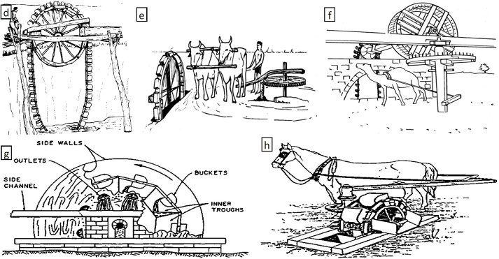
Of these, the devices “e” and “g” do yield measures of performance somewhat comparable to what Baldwin claimed for his hydraulic machine.
But, if Baldwin was familiar with these, yet claimed that his was “a machine built on new principals”, how did it depart from the ancient bucket wheel devices? Or, could it be that Baldwin was not familiar with these devices and simply reinvented something similar to meet his own needs?
 For the moment, these will remain unanswered questions. However, William Weston’s engineering notes are archived at the Civil Engineering Library in London. I have asked them to do a search for any further information about Loammi Baldwin’s pump. Most regrettably, that library recently experienced a flood and has placed many items in temporarily inaccessible storage. They’ve promised to check on my request when they can again gain access to the notes, so it may yet be possible to learn more about Baldwin’s Hydraulic Machine. Stay tuned!
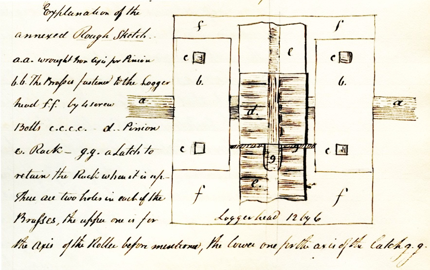
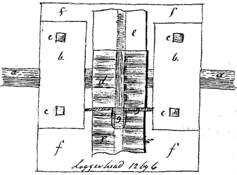
Explanation of the annexed Rough Sketch
a.a. wrought Iron Axis for Pinion
b.b. The Brasses fastened to the Logger head f.f. by 4 screw Bolts
c.c.c.c. - d. Pinion e. Rack -
g.g. a Latch to retain the Rack when it is up. There are two holes in each of the Brasses, the upper one is for the Axis of the Roller before mentioned; the lower one for the axis of the latch g.g.
Footnotes:
1 Canal Terminology of the United States; by Thomas Swiftwater Hahn and Emory Kemp; published by the Institute for the History of Technology and Industrial Archaeology, Eberly College of Arts and Sciences at West Virginia University, in cooperation with the National Park Service and West Virginia University Press; p-72
2 Courtesy, The Winterthur Library: Joseph Downs Collection of Manuscripts and Printed Ephemera, Col. 204.
3 Author’s transcription from handwritten copy. I thank Jeanne Solensky, Librarian,Winterthur Library, Downs Collection, for proofing my transcriptions and contributing appreciably to them. BG
4 Lewis M. Lawrence, The Middlesex Canal, 1942 Manuscript, pp 23 & 24
5 http://www.mdpi.com/2073-4441/7/9/5031/htm; Evolution of Water Lifting Devices (Pumps) over the Centuries Worldwide; Stavros I. Yannopoulos , Gerasimos Lyberatos, Nicolaos Theodossiou, Wang Li, Mohammad Valipour, Aldo Tamburrino and Andreas N. Angelakis ; p-5038 (in PDF format)
“Winchester Culvert: Location”
by J. Jeremiah Breen
In 1829, the wooden aqueduct carrying the Middlesex Canal over the Symmes River in today’s town of Winchester was replaced by a granite culvert.
“Aqueduct at Symmes River rebuilt, solid timber floors were sunk to the bottom of the river, 8 culvert walls 4 ft. in thickness, 6 ft. in height, and 100 ft. in length, were laid from 6 ft.. to 7 ft. apart parallel with each other and directly under the old aqueduct. These culverts were covered with stones 8 ft. in length and 18 inches in thickness resting upon the walls. A wall of about 6 ft. in height and 4 ft. in thickness was raised upon the ends of the culverts to support the banks of earth. After the stone work was completed --- a bed of clay mortar 8 inches thick was laid on the covering stones. --- the width of the Canal where it passes over the new culverts is 40 ft. at the top, 20 ft. at the bottom, and 5 ft. in depth. The old aqueduct was about 14 ft. in width and caused great delay to boats.” Report of January 17,1828, in the original records of the proprietors, Office of Engineer of Middlesex County, Court House, East Cambridge, quoted by Lewis M. Lawrence, The Middlesex Canal (1942), p. 111.
Curiously, the author of the report describes the construction of the culvert as a re-building of the aqueduct rather than as a replacement of it. Consistent with this conflation was the identification of the culvert and its location in later years as the Symmes Aqueduct.
The modern understanding is that the aqueduct and culvert were located where the Symmes River today flows from the Upper Bay to the Middle Bay of the Mystic Lakes. The address is Sandy Beach, 4 Mystic Valley Parkway, Winchester 01890.
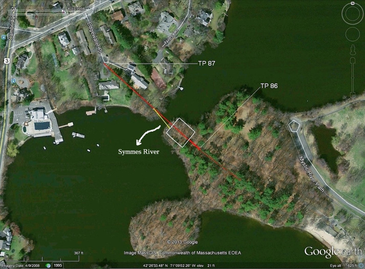
Location of Symmes River, 2016 Google Earth
However, George Baldwin in 1829 surveyed the Middlesex Canal, recording the location to the nearest link (~ 8”) in a Gunter’s chain as follows:
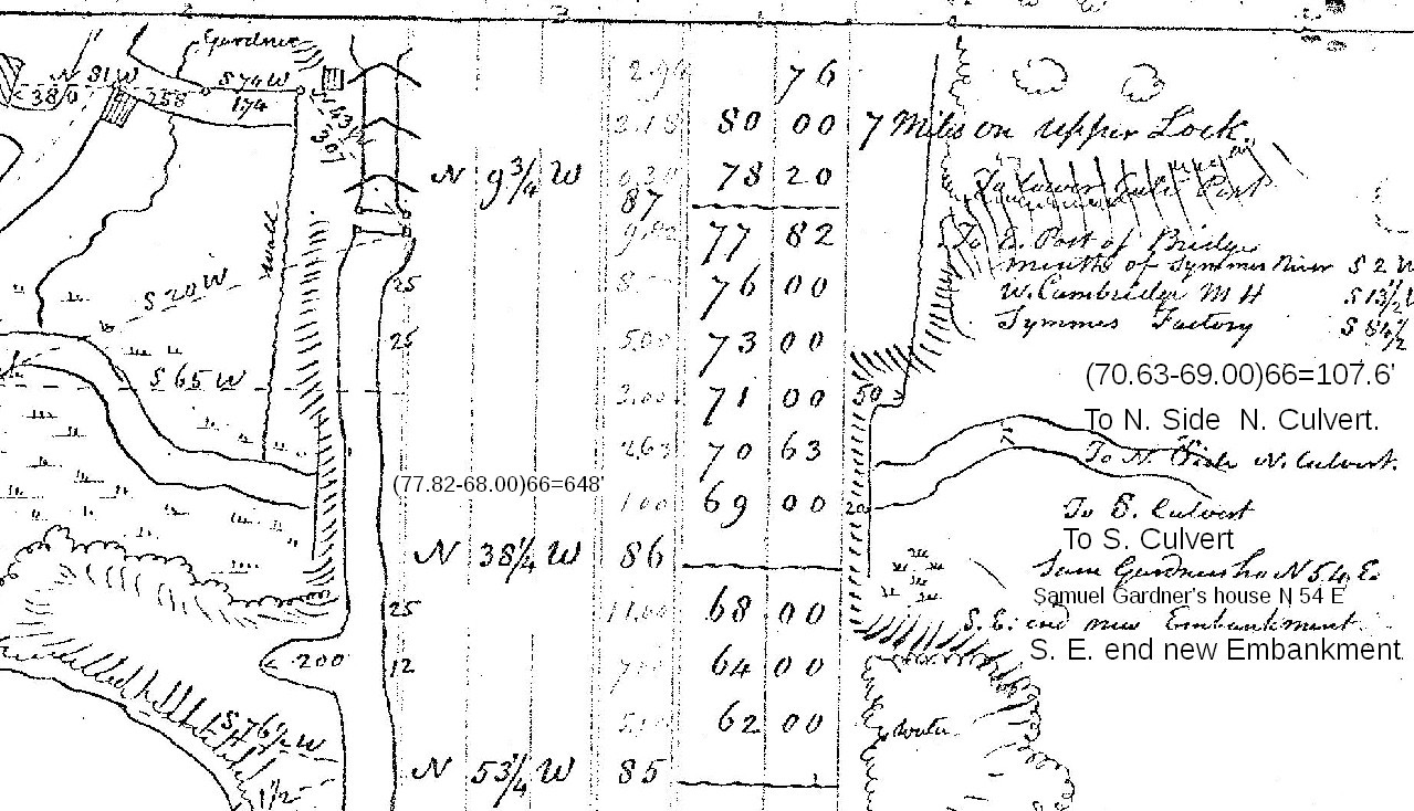
Using the 1829 measurements,1 the location of the culvert can be plotted in 2016. In particular, the canal basin at 64.00 chains exists today and provides a known point from which to measure distances. Not really a point at Sandy Beach in 2016, rather a known location within, say, some tens of feet of the 1829 basin at 64.00 chains. Thus the white rectangle on the Google Earth view is the culvert between 69.00 and 70.63 chains (difference 107.8’) on the surveyed line of the canal and the 100’ walls transverse to the canal.
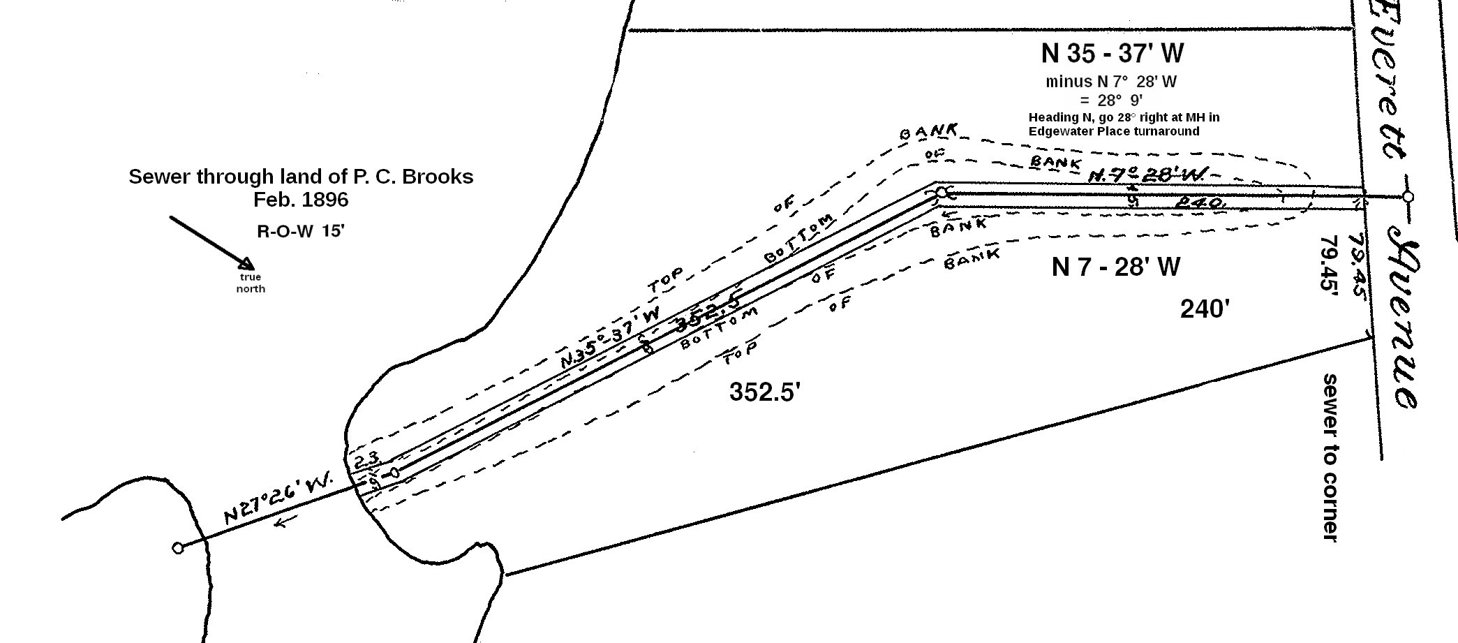
The yellow line is between the manholes of the siphon of an 1896 sewer under the river. The red line between turning points 86 and 87, length of 648’, is significant because its bearing is known precisely in 2016 when other historical items are not. The 1896 sewer is congruent with the property line between 3 and 4 Edgewater Place and in the center of the canal bottom as shown in the following engineering drawing: 2
Therefore the 1829 surveyed bearing between TP86 and 87 is parallel to the property line which Google displays. Note though, that Baldwin drew the canal between 86 and 87 as an irregular curve.
From his measurements, Baldwin drew a plan of the canal at the Symmes River.3 (below)
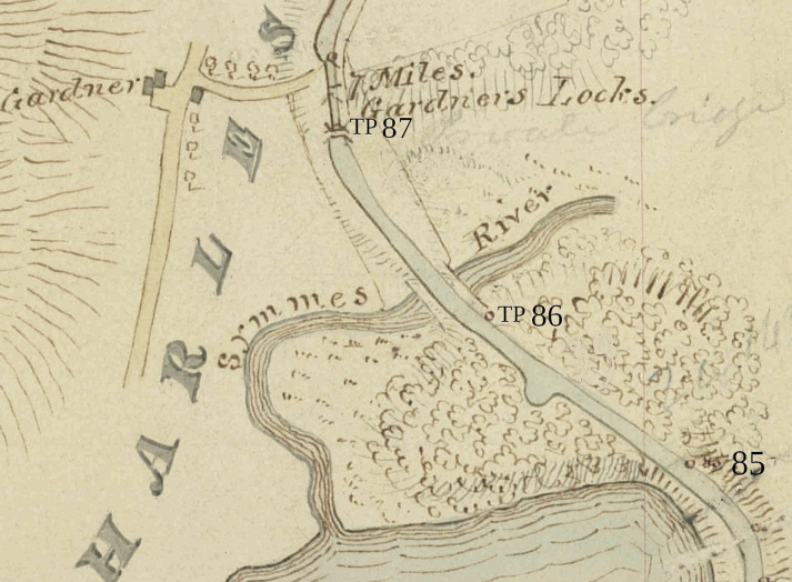
George Rumford Baldwin's 1829 Plan of the Canal at the Culvert
An overlay of 1829 Baldwin on 2016 Google Earth follows (below).
1829 Baldwin Overlay on 2016 Google Earth
The artist Dahill studied the topography of the Symmes River location for his pastel, Middlesex Canal at Symmes River 1829, reproduced below, painted for J. Breen’s October 18, 2016 talk for the Winchester Historical Society. When seeing the 2016 Google Earth with the 100x108’ white rectangle but not with overlay for the first time at the talk, he exclaimed that the river along the high ground northeast of the culvert was the natural location not the channel in 2016. He has proven ability in ground recognition having flown 46 WWII bomber missions as navigator looking for waypoints in the Pacific.
The shift in the natural river channel northwest 120’± to the present channel probably occurred when an ice dam or other blockage at the culvert caused flooding in Winchester. By 1864, the Charlestown Water Works had built a dam which raised the water level in the Upper Mystic Lake, likely to what is today the normal level, 7.74’ (NAVD88). The canal towpath on the embankment over the culvert was at el. 23’±.4 The Jan. 1828 report above says the depth was 5’, indicating the canal bed was 6’ below the towpath, or el. 17’. To relieve the flooding, explosives were likely placed in the canal bed to create a breach in the embankment through which the flood waters could erode a new channel.
If the breach had been exploded over the culvert, the rushing flood waters would likely have stopped eroding deeper when the top of the 4’ thick granite headwall was reached. Thus the breach was made in the embankment over the low ground northwest of the culvert.
Walking in the canal in 2016 from Sandy Beach to the Symmes River, the berm is on the left and the towpath on the right, 4’ ± above the pavement and broader than the berm. At the parapet, the lack of a towpath is more likely due to park and sewer construction than to removal of the culvert for use as building stone. Likely the hundreds blocks of granite in Tom Raphael’s 1994 article5 came from the two headwalls, both 120’, 4’ wide, that retained the embankment 6’ above the culvert. The headwalls were above the water level of the Mystic Lakes Dam. That the granite of the underwater culvert wasn’t removed when the headwalls were is certain, for the embankment is still there.
Remove the earth over the culvert, remove the granite, then fill the 108’ long, 100’ broad, deep hole upto the level of the canal, was not done. The culvert is there.
1965 As-built Drawing of 2nd Symmes River Inverted Siphon
However, in 1964 a second 16” siphon was built under the Symmes River. The November 1965 as-built drawing records the “Remains of aqueduct foundation”, “10”x10” Timbers doweled together”, “Granite blocks”, and a “Stone Abutment”. Frank W. Lovering wrote about the construction in the December 21, 1964 issue of the Medford Daily Mercury, reprinted in the March 1965 Towpath Topics. The 1894 drawings of the first 16” siphon do not record aqueduct remains. The 1964 remains west of the “Stone Abutment” contradict the argument based on topography and Baldwin’s 1829 survey that the culvert was east of the abutment. Unless granite remains are found east of the abutment, the present location of the Symmes River was the location of the 1829 culvert. Another article on the Winchester culvert will have it in place west of the “Stone Abutment”.
Middlesex Canal at Symmes River 1829
Notes
1. The measurements are in George Rumford Baldwin’s Field Book No. 5, September 1829, in the Baker Library (Harvard Business School), Baldwin Family Business Papers. A Xerox copy is in the library of the Middlesex Canal Visitor Center/Museum, Billerica MA 01862.
2. Original, non-enhanced 1896 drawing is in the Winchester town engineer’s office.
4. Towpath Elevation. (Gardner miter sill, 18.23’)+(3½’ minimum depth of canal)+ (towpath, 1’ higher)=22.73’, say 23’. Miter sill from 1830 profile, note 3 above. The profile has the water surface of the Symmes River at 3.39’ (NAVD88). The water in the canal is 23’ -1’ - 3.39’, or 19’, above the water in the Symmes River.
Datum Conversion Table
As NAVD88 varies by location, factors just for Winchester. Range, .804-.810, av .807’.
NAVD88 + 0.81’ = NGVD29
NAVD88 + 4.65’ = Baldwin 1830
NAVD88 + 7.46’ = Town of Winchester
NAVD88 + 106.46’ = Metropolitan District Commission5. Tom Raphael, “More on the Canal Stones in the Winchester Town Forest”, Towpath Topics, Sept. 1994.
Thomas Jefferson, Canals, and Waterways
by Dan Van Haften
Thomas Jefferson succeeded Benjamin Franklin as the American Minister to France in 1785. He traveled from Paris to London, to the Netherlands, and along the Rhine River. However, his most extensive, and best loved trip, was his 1787 trip to the south of France. Jefferson left Paris on February 28, and returned to Paris on June 10. He wrote 44 pages of notes on his travels, and numerous letters. Jefferson observed from Provence, “I am now in the land of corn, wine, oil, and sunshine. What more can man ask of heaven? If I should happen to die in Paris I will beg of you to send me here, and have me exposed to the sun. I am sure it will bring me to life again.”
Thomas Jefferson spent nine days on the Canal of Languedoc, as the Canal du Midi was called in his day. This is what Thomas Jefferson observed on the Canal of Languedoc: (1) canals were the pleasantest mode of travel; (2) the investment and engineering aspects were substantial; (3) geographical detail was an important consideration for waterways; (4) canals had significant commercial benefits.
During his trip Jefferson wrote: “I have passed through the Canal from its entrance into the Mediterranean at Cette to this place, and shall be immediately at Toulouse. I dismounted my carriage from its wheels, placed it on the deck of a light bark, and was thus towed on the canal instead of the post road. I have made from 20 to 35 miles a day, according to circumstances, always sleeping ashore. Of all the methods of traveling I have ever tried this is the pleasantest.”
Jefferson was interested in the engineering aspects of canals. He visited and recorded dimensions for canal locks, including the Agde Round Lock. Jefferson wrote regarding his nine day trip on the canal: “The barks which navigate it are 70 and 80 feet long, and 17 or 18 feet wide. They are drawn by one horse, and worked by two hands, one of which is generally a woman. The locks are mostly kept by women, but the necessary operations are much too laborious for them.”
Jefferson wrote: “I walk the greater part of the way along the banks of the canal, level, and lined with a double row of trees which furnish shade. When fatigued I take a seat in my carriage where, as much at ease as if in my study, I read, write, or observe. My carriage being of glass all round, admits a full view of all the varying scenes through which I am shifted, olives, figs, mulberries, vines, corn and pasture, villages and farms.” Jefferson wrote, “The passage of the eight locks at Bezieres, that is from the opening of the first to the last gate, took one hour 33 minutes.”
Thomas Jefferson wrote about the commercial aspects of the French canal system. On March 9, 1787, he observed: “I passed three times the canal called le Charollois, which they are opening from Chalons on the Saone to Digoïn on the Loire. It will reanimate the languishing commerce of Champagne and Burgundy, by furnishing a water transportation for their wines to Nantes.”
In 1787, Jefferson speculated in a letter from Paris that to deny access to the navigation of the Mississippi would be “an act of separation between the Eastern and Western country”. It would be “a relinquishment of five parts out of eight of the territory of the United States.”
Almost a year after inspecting the Canal of Languedoc, Jefferson wrote George Washington from Paris regarding the communication between the Cayahoga and Big Beaver Rivers: “I have ever considered the opening a canal between those two watercourses as the most important work in that line which the state of Virginia could undertake. It will infallibly turn through the Patowmack all the commerce of Lake Erie and the country West of that, except what may pass down the Missisipi. And it is important that it be soon done, lest that commerce should in the meantime get established in another channel.”
In 1790, Secretary of State Jefferson argued, “navigation cannot be practiced without a port, where the sea and river vessels may meet and exchange loads.” The river he wrote about was the Mississippi. The port was New Orleans, the city that provided access to the Gulf of Mexico from the Mississippi River.
In December, 1799, Vice-President Jefferson provided specifications for his personal canal along Virginia’s Rivanna River. “The canal must be two feet deep at its mouth in a summer tide, five feet wide at bottom; and the whole fall from the upper to the lower end should be about two feet.”
The United States needed infrastructure. Infrastructure required capital. Jefferson observed the results of investment made in the Canal of Languedoc. In 1800, Vice-President Jefferson wrote regarding investment in the Patowmack & Norfolk Canals: “Their completion is rather more distant. The prices of [stock] shares in these also are below par. The progress of these works had encountered difficulties not foreseen & their maintenance will be more expensive than was expected. Still their profits, which are tolerably well in the beginning, will increase in the geometrical ratio of population & produce.” Ultimately the Patowmack & Norfolk Canals were built as the Chesapeake and Ohio Canal, and the Albemarle and Chesapeake Canal, respectively.
In 1802, President Jefferson wrote Robert Livingston, the American Minister to France: “Of all nations of any consideration, France is the one, which, hitherto, has offered the fewest points on which we could have any conflict of right, and the most points of a communion of interests.” He continued, “There is on the globe one single spot, the possessor of which is our natural and habitual enemy. It is New Orleans.” President Jefferson’s 1802 letter emphasized the point he made in 1790 as Secretary of State regarding New Orleans’ importance to American commerce.
In 1803, France agreed to sell not only New Orleans, but all of Louisiana to the United States. Thomas Jefferson persuasively argued that Americans should support the $15,000,000 Louisiana Purchase.
The new Louisiana Territory led to Jefferson’s persuasive argument to Congress to allocate $2500 for the Lewis and Clark expedition. His reason was “for the purpose of extending the external commerce of the United States.” In 1803, Jefferson provided instructions to the expedition leader: “The object of your mission is to explore the Missouri river, & such principal stream of it as by its course and communication with the waters of the Pacific ocean whether the Columbia, Oregon, Colorado or any other river may offer the most direct & practicable water communication across this continent for the purposes of commerce.”
In 1806, Jefferson reported back to Congress that the expedition, now completed, “traced the Missouri nearly to its source, descended the Columbia to the Pacific Ocean, ascertained with accuracy the geography of that interesting communication across our continent.”
Jefferson wanted new channels of communication between states to help strengthen the union. He realized that in France there was a certain efficiency of administration. It was easier for the French government to make infrastructure investments because of its system of government. Jefferson was concerned the United States government could not constitutionally fund national infrastructure improvements. In his 1806 message to Congress, Jefferson spoke of “roads, rivers, canals, and such other objects of public improvement as it may be thought proper to add to the constitutional enumeration of Federal powers.”
In 1807, President Jefferson wrote, “People generally have more feeling for canals and roads than education. However I hope we can advance them with equal pace.” Jefferson’s Secretary of the Treasury, Albert Gallatin, prepared an 1808 report on internal improvements. The report began: “The general utility of artificial roads and canals, is at this time so universally admitted, as hardly to require any additional proofs.” He further noted, “---the Middlesex Canal, uniting the waters of that (Merrimack) river with the harbors of Boston, is the greatest work of its kind which has been completed in the United States, to date”.
Even in his retirement, Thomas Jefferson thought about canals. He wrote New York Governor Dewitt Clinton an 1822 letter about the Erie Canal: “I rejoice sincerely in the progress of your canal, and envy your location in a state wise enough to see that the common interest is individual interest, and rich enough to pursue it.” Jefferson knew and appreciated the investment, the commercial benefit, and the ease of transport to the Great Lakes. These were all lessons reinforced by his visit to the Canal of Languedoc.
At the 2016 Presidential Elections,
Billerica adopts the Community Preservation Act.
by Marlies Henderson
Many citizens have relentlessly pursued the preservation of the Middlesex Canal heritage corridor with a burning passion, but once funding dried up in 2008, not much progress could be made. That is why I spearheaded a petition in Billerica to get adoption of the Community Preservation Act (CPA) on the November 8 ballot as a municipal question.
CPA enables a community to create a local fund to protect its natural and cultural resources, by adding a surcharge to local real estate taxes.
The local CPA fund receives yearly guaranteed disbursement matches from a statewide trust fund. All Commonwealth communities contribute money for the matching funds, but only cities and towns that adopted the CPA receive a slice of the pie. Since the CPA was signed into law in 2000, 161 communities adopted the Act and benefited from it.
Besides petitioning to get a question on the ballot, Billerica petitioners also submitted a 2016 Fall Town Meeting Warrant Article for a bylaw change to establish a Billerica Community Preservation Committee (CPC). The article passed.
The bylaw change will take effect after the Attorney General signs off on it. This may take up to 90 days, and it is expected to be ratified by January 19, 2017. The Town Clerk then posts the bylaw change. By then, the appointing entities can be notified to appoint the new committee members in compliance with the new bylaw.
It took a small group of believers all summer to collect certified signatures of 5% of registered voters in Billerica. After reaching the required 1500 signatures, a ballot question committee was established, and funds were raised to get the word out on ballot Question 5.
The committee was so consumed by the YES on 5 campaign that it almost forgot that Election Day also involved a vote for a Presidential candidate! After a contentious campaign, Billerica citizens voted to adopt CPA. The Billerica surcharge will be 1%, and generous exemptions apply. The Boston Globe commented:
“In the midst of an unsteady period of malice and estrangement, thousands of Massachusetts voters stood up for their shared values. It turns out that “community preservation” means more than we knew.”

John and Brian
Wilmington, Woburn and Winchester do not have CPA (yet), but Chelmsford, Billerica, Medford, Somerville and Charlestown should all consider submitting proposals for the Middlesex Canal to their CPC (Community Preservation Committee) in 2017! Make that your New Years’ resolution!
Serendipity Sets the Pace for other Corporations
by Marlies Henderson
In a generous offer to vividly connect us with past and future generations of Billerica, Pace Industries undertook a repair of their shipping and receiving deck this year, which included a stunning restoration of a portion of the Middlesex Canal.
The Billerica Minuteman reported: “After a dump truck caused major damage […] the plan was to fill the area with concrete. Thanks to a multi-organization collaboration, the lock has been restored [… ] preserving the historical and environmental value in the process.” Indeed, the Billerica Conservation Commission helped the engineers perfect the plans for protecting natural resources as well as historic ones.
The Lowell Sun reported that Pace paid more than $100,000 for the project. Twenty years after Tom Raphael planted a seed of inspiration in the minds of CEO Bill Donovan and Purchase Manager Marc Turcotte, they brought the seed to fruition. They preserved a unique portion of the 27 mile canal, which in 1808, U.S. Treasury Secretary Albert Gallatin considered “the greatest work of its kind that has been completed in the United States.”
The display is unique because, as described in the President’s Letter for the September 2016 Towpath Topics: “Of all twenty locks originally part of the 19th century canal, this west guard lock is the only one still visible.” The other 19 have either been dismantled or buried.
Fortuitously, these lock chambers remained extant, initially, because the channel had been used as a head race for two turbines in the Talbot Mill, generating electricity at 550 volts AC. Even after discontinuing the hydropower option in 1968, the lock remnants were left intact, simply because there was no other use for the area. But for the past 25 years, the significance of historic preservation appeared on the radar, and all that was needed was a serendipitous dump truck sinking through the deck to escalate steps moving forward and make a dream come true.
On December 1, 2016 several stakeholders attended an event to acknowledge this highlight:
From left to right: Tom Raphael, Marlies Henderson, Bill Donovan (Pace, CEO), J. Jeremiah Breen, Isabel Tourkantonis (Director of Environmental Affairs with the Town of Billerica), John Piscatelli (Board of Selectmen, Town of Billerica), Alec Ingraham, Ellery Schemp and partner Arlene Germain , Andrew Bowen, Rob Anderson (Economic Development Agent with the Town of Billerica), and Marc Turcotte (Pace, Purchase Manager).
Billerica Historical Commission
2015 Community Grant Report
Landscaping Middlesex Canal Wayside Marker
High Street, North Billerica, MA
As part of the 2015 Community Grant cycle, the Billerica Historical Commission was fortunate to receive $2,338 from EMD Serono for landscaping and restoration work at the site of the Middlesex Canal wayside marker on High Street. The initiative was finally completed in early October.
In June of 1997, the marker was originally dedicated by the Middlesex Canal Commission. It was the last of nine, location specific stone obelisks, to be placed along the route of the canal, but the first major initiative of the Middlesex Canal Commission: Billerica Section. During the ensuing years, despite the efforts to maintain the site which is owned by Iron Mountain Company, the underbrush engulfed the marker and made accessing the site difficult. This prompted the Billerica Historical Commission to include the restoration effort as part of its 2015 Community Grant application.
On October 5, 2016, twenty people attended the rededication ceremony. Publicity for the event appeared in a September 29, 2016, Billerica Minuteman article by Judy Wasserman. BATV filmed the entire affair which included a catered lunch at the Middlesex Canal Museum and Visitors’ Center followed by a motorcade to the High Street location. Speakers included BHC and MCC Chair, Alec Ingraham; Middlesex Canal Association Vice President, Traci Jansen; and Billerica Town Manager, Mr. John Curran. During the observance EMD Serono, the Middlesex Canal Association and the MCC: Billerica Section were recognized for supplying monetary support for the restoration. The event, however, was dedicated to the members of the MCC: Billerica Section who were involved when the marker was originally placed but are now deceased: Marion Potter, former chair, John Reardon, former vice chair, Rev. Carl Seaburg and Helen Knight. Fittingly the marker was unveiled at the conclusion of the occasion by Stuart Potter, Jr. (Marion’s son) and Isabel “Shayne” Reardon (John’s wife).
Summary History of the Middlesex Canal, the Route of which traversed North and East Billerica:
The Middlesex Canal was incorporated in 1793 and completed by 1803. The 27-mile canal permitted travel from the Merrimack River to the tidewater in Charlestown. The Concord River supplied the majority of water used to fill the entire canal. In North Billerica, the summit pond, created by damming the river, was the highest point on the route of the canal. Eight aqueducts and twenty locks along with numerous culverts and bridges were constructed to facilitate travel. A floating tow path was built to allow canal boats to cross the Concord River.
Competition from the Boston and Lowell Rail Road (opened 1835), the route of which paralleled the waterway, forced the canal out of business after nearly 50 years in operation. Prior to this time a network of canals and rivers afforded interstate travel from Boston to Concord, New Hampshire. In addition to passengers the horse drawn packet boats and barges hauled raw materials “down” from New Hampshire and finished goods “up” from Boston. In 1808, Albert Gallatin, Secretary of the Treasury, called the Middlesex Canal “the greatest work of the kind which has been completed in the United States.”
Financial Information for the Project
| Organization | Funding Provided |
| EMD Serono (2015 Community Grant Cycle) | $2,338.00 |
| Middlesex Canal Association | $1,700.00 |
| Middlesex Canal Commission: Billerica Section | $2,339.90 |
| Total | $6,377.90 |
Expenditures
| Company | Service | Invoice |
| Salt Box Nursery, Boston Road, Billerica, MA | Landscaping including removal of debris and pea stone path | $5,817.90 |
| Sign Effects High Street, N. Billerica, MA | Signage | $360.00 |
| Luz Monument Works, Gorham St., Lowell, MA | Cleaning and leveling the marker | $200.00 |
| Total | $6,377.90 |
In closing the Billerica Historical Commission would like to thank the many individuals who helped in making the event a success. The list includes but is not limited to the Town of Billerica, Bob Ledger for supplying the sound system, Deb Fox for recording the event in pictures, Betty Bigwood and Traci Jansen for helping out with arrangements, Andy Bowen supplying the catered lunch, and Sarah Mills for the invitations.
Pictured (L to R): Howard Winkler, Betty Bigwood, Mr. John Curran, Thomas Raphael
Mr. John Curran in foreground, Alec Ingraham at podium, Shayne Reardon
and Stuart Potter, Jr. unveiling marker, and Nancy Albertson filming for BATV
Overview of the Restoration - Pictured: Alec Ingraham in yellow,
Andy Bowen, Ann Stedtman, and Bob Ledger, seated
A Probable Scene On The Middlesex Canal And Merrimack River
by Howard Winkler
Recently, I was in St. Louis visiting my family and we went to the St. Louis Art Museum to see Navigating the West: George Caleb Bingham and the River, an exhibition of his paintings. I was struck by The Jolly Flatboatmen in Port and thought about the commonality between 19th century flatboatmen working on rivers and canal boatmen. We have no similar painting relating to our canals. I would expect a commonality of personality and dress. Also, they all worked hard, drank, cursed, smoked, gambled, and wooed the ladies.
I would guess that when the boats had to be tethered for the night, crews would assemble for entertainment, especially if a tavern was not nearby.
Flatboat work on rivers was more challenging than canal boat work, as the river current was swifter, and there were snags to be avoided.
The Jolly Flatboatmen in Port, 1857 by George Caleb Bingham (1811-1879)
MISCELLANY
Back Issues - Fifty years of back issues of Towpath Topics, together with an index to the content of all issues, are also available from our web site at http://middlesexcanal.org/towpath. These are an excellent resource for anyone who wishes to learn more about the canal and should be particularly useful for historic researchers.
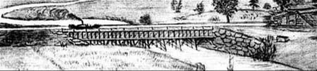
Back Page - Excerpt from an August,1818, drawing (artist unknown) of the Steam Towboat Merrimack crossing the original (pre-1829) Medford Aqueduct, probably on its way to service on the Merrimack River.
Estate Planning - To those of you who are making your final arrangements, please remember the Middlesex Canal Association. Your help is vital to our future. Thank you for considering us.
Museum & Reardon Room Rental - The facility is available at very reasonable rates for private affairs, and for non-profit organizations’ meetings. The conference room holds up to 60 people and includes access to a kitchen and restrooms. For details and additional information please contact the museum at 978-670-2740.
Museum Shop - Looking for that perfect gift for a Middlesex Canal aficionado? Don’t forget to check out the inventory of canal related books, maps, and other items of general interest available at the museum shop. The store is open weekends from noon to 4:00pm except during holidays.
Nameplate - Excerpt from an acrylic reproduction of a watercolor painted by Jabez Ward Barton, ca. 1825, entitled “View from William Rogers House”. Shown, looking west, may be the packet boat George Washington being towed across the Concord River from the Floating Towpath at North Billerica.
Web Site – The URL for the Middlesex Canal Association’s web site is www.middlesexcanal.org. Our webmaster, Robert Winters, keeps the site up to date. Events, articles and other information will sometimes appear there before it can get to you through Towpath Topics. Please check the site from time to time for new entries. Also, the site now contains a valuable repository of historical information, all the back issues of TT, and an index to all of the articles contained therein, and now can be found there at http://middlesexcanal.org/towpath.
The first issue of the Middlesex Canal Association newsletter was published in October, 1963. Originally named “Canal News”, the first issue featured a contest to name the newsletter. A year later, the newsletter was renamed “Towpath Topics.”
Towpath Topics is edited and published by Debra Fox, Alec Ingraham, and Robert Winters.
Corrections, contributions and ideas for future issues are always welcome.