
![]()
|
Middlesex Canal Association |
Volume 40 No. 2 |
Contents:
SPRING WALK
ANNUAL MEETING
PRESIDENT'S MESSAGE
BURT VERPLANCK: October 16, 1917 - November 27, 2001
MEMORIES OF “BURT” VERPLANCK - by Roger Hagopian
OUR FALL CANAL WALK 2001 - by Roger Hagopian
FRAN AND BURT’S WONDERFUL ADVENTURE - by Alan
Seaburg
THE ROAMING MIDDLESEX CANAL TOLLHOUSE (Now on
Chelmsford Common) - by Jane Drury
CANALS OF THE MERRIMACK RIVER - by William E.
Gerber
VERPLANCK MEMORIAL FUND
MIDDLESEX CANAL
ASSOCIATION
SPRING WALK
Date: Saturday, April 27, 2002
Time: 1:30 pm
Place: Billerica
The Middlesex Canal Association Spring Walk will originate at the Middlesex Canal Museum and Visitor Center at the Faulkner Mills on Faulkner Street in North Billerica. The Museum and Visitor Center will open at 12 noon, and there will be hot dogs, soda and chips available for purchase. Our bookstore will be open as well. The walk will cover the route of the canal in Billerica; sites will include a lock, anchors for the floating towpath bridge across the Concord River, and many stretches of watered canal. The walk will cover about 4-5 miles over generally level wooded terrain and streets in about 2-2½ hours.
Directions: From Route 3, take exit 28, Treble Cove Road. Turn towards North Billerica. At about ¾ mile bear left at a fork. After about another ¾ mile, cross Route 3A at a traffic light. Go about ¼ mile to a 3-way fork; take the middle road, which will put St. Andrew’s Church on your left. Go about ¼ mile; bear right, then turn right onto Faulkner Street. Go about ¼ mile. The Museum & Visitor Center is on your left, and you can park across the street on your right, just beyond the falls.
Information: Bill Gerber 978-251-4971, or Roger Hagopian 781-861-7868, or visit the web site: www.middlesexcanal.org.
MIDDLESEX CANAL
ASSOCIATION
ANNUAL MEETING
The tentative date for the Annual Meeting is Sunday, May 5, 2002 at the Middlesex Canal Museum and Visitors Center. The event will include our annual business meeting, including election of officers for the coming year, and a speaker. An announcement will be mailed separately to all members and proprietors nearer to the date.
Our activity level continues at a vigorous pace. The museum will be opening on Saturday, April 6 for weekends through the summer (12-4 pm). We try to have two docents on duty each day and we are short of docents. If you can staff the museum from 12-4 on Saturdays or Sundays occasionally, please let us know. Call the Museum at 978-670-2740.
Recent speaking engagements have included a retirement home, the Charles River Power Squadron, and a hiking club. We welcome requests as opportunities to tell the story of the Middlesex Canal.
We have not managed to arrange field trips to nearby canals but it is still on the agenda. We hope to have someone from the Blackstone Canal conservancy at our annual meeting and information about their “Canal Days”. Canal Society of New Jersey's Canal Days will be June 22 at Waterloo Village.
Nolan Jones, President
BURT VERPLANCK
October 16, 1917 - November 27, 2001
Former Middlesex Canal Association President Warburton (Burt) VerPlanck passed away on Nov 27, 2001. Burt was president of the Association during the years 1990-1995. He and his wife Fran are known to all of us as “Mr. and Mrs. Middlesex Canal” for their years of dedicated service. Educated at Exeter and Yale, he was a gentleman of the highest order whose kind and meticulous leadership will be long remembered. He worked tirelessly to complete the definitive “Middlesex Canal Guide and Maps” showing access and available trails along the canal. He leaves his wife Fran, four children, and seven grandchildren.
-Betty Bigwood
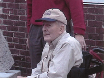
Burt VerPlanck in the fall of 2001 at the Museum (photo by Tom Dahill)
MEMORIES OF “BURT” VERPLANCK
by Roger Hagopian
In the late 1980s, after decades of interest in the Middlesex Canal, I found myself standing with a group of prospective hikers as we awaited the start of a trek along the route of the old waterway. Suddenly there appeared a small blue station wagon with a homemade wooden sign strapped to its roof and from it emerged a slight soft-spoken man wielding a megaphone. This was my introduction to Burt and Fran VerPlanck, “Mr. and Mrs. Middlesex Canal.” Naturally I joined the Association after that and two months later I was stunned to receive a phone call from President Burt VerPlanck to join the board of directors. In those days the meetings were held at various homes, most notably, the spacious living room of the VerPlanck residence in Winchester. What at first had struck me as a “Mom and Pop” organization quickly revealed itself as a group of intellectual and caring people with Burt at the helm. I truly looked at Burt as a leader and a father figure.
For years Burt had been preparing a Middlesex Canal Guide book for publication and still needed to ascertain the location and condition of the canal in various locations. I had been searching for a way to validate myself as a board member when I began to casually videotape the extant segments of the canal. Together we completed our projects as Burt would drive and I would hike with my camera and report to him. A stickler for detail, he would often ask as to the exact condition of the canal. "Was it watered or dry?" When I responded he would inquire further. “What about the Spring or Fall? Let's check it then as well.” On one of our excursions we encountered some wild geese, “nature's finest,” guarding the canal and clearly annoyed at our presence. How could they possibly know that the true steward of the Middlesex Canal was Burt VerPlanck, historian and gentleman?
OUR FALL CANAL
WALK 2001
by Roger Hagopian
Last October members and guests of the Middlesex Canal Association under the leadership of Bill Gerber and myself, traversed the section of canal bed and remains leading from Sandy Beach in Winchester south toward Medford along the Mystic Valley Parkway. While landmarks remain, such as the Symmes River (Upper Mystic Lake) aqueduct stones, nearby basin, the canal inn and tavern/locktender's home and the abutments to the Mystic River Aqueduct, the exact route of the canal in the wooded area along the parkway remains in question.
What was a pleasant ambulatory experience for some became an archaeological investigation for others and with the help of two walkers named Doug and Bruce we were able to further determine the location of the Middlesex Canal in this area.
Based on an article in the New England Magazine 1898 and a map of the installation of the sewer line between Winchester and Medford in the 1890s it is clear that the pipes had been laid in the Middlesex Canal bed with manhole covers sporadically marking the route. Realizing that the canal, railroad, sewer line and parkway all occupied the same strip of land along the east shore of the Mystic Lakes, we followed the sewer covers as they lay in or along the parkway. When they deviated from the road and entered the woods it was clear that we were in the canal bed and, sure enough, there appeared a well-preserved stretch of towpath (It was located on the east bank of the canal in this area). We followed the sewer manhole covers and canal bed out of the woods to the parkway, where the sewer line resumed its winding course in and out of the woods before reaching the residential neighborhood of West Medford. In a way the Middlesex Canal still lives, and water, sort of, flows along its path, or under it, although not quite in the form its creators would have imagined.
FRAN AND BURT’S
WONDERFUL ADVENTURE
by Alan Seaburg
[Editor’s note: This article was contributed to us just before Burt VerPlanck’s passing, and we feel our readers would enjoy reading it.]
It was on the 20th of October, the day of the MCA’s fall walk, and what a lovely sunny brisk New England day that was. Their adventure was visiting the new Middlesex Canal Museum in Billerica, and the “their” were those delightful friends of the canal Fran and Burt VerPlanck. Between them, as it says in the dedication to them in The Incredible Ditch, they have contributed “over 50 years (25 years each) … of caring attention to the old canal.” This includes leading fall and spring walks, and faithful service as presidents of the MCA, Fran from 1977 to 1981 and Burt from 1990 to 1995.
They arrived at the museum at about 10:30 and were brought there by two of their children: their son Ted, down from Maine where he lives, and their daughter Kay. Although the museum was officially closed, several longtime members of the MCA were on hand to show them the wonders of the place: Nolan Jones, Tom Dahill, Betty Bigwood, Roger Hagopian, and Alan Seaburg. Both Roger and Tom had their ever-present cameras with them and so the adventure was fully documented for the museum’s archives.
Although Burt now travels in a wheelchair, and Fran uses a cane, the two of them – who already seem to know the canal from A to Z – insisted on viewing the museum’s every nook and cranny. They missed nothing, and commented often on how much devoted work the people of Billerica had already put forth to create this very special place. Among the displays they especially enjoyed were the various models of the canal on exhibit, Tom Dahill’s attractive drawings and watercolors, and Roger Hagopian’s video. Before they departed at noon, all present sat in the sunny kitchen with its green curtains and shared the glasses of lemonade and cookies that Betty Bigwood provided for the occasion. Then, after shopping at the museum store, these warm and wonderful folks took their leave – each sporting a brand new museum hat.
THE ROAMING MIDDLESEX CANAL
TOLLHOUSE
Now on Chelmsford Common
contributed by Jane Drury
Why and how did the Middlesex Canal tollhouse end up on the Chelmsford Common? That is a question often asked by people who see it sitting there. It has been moved five times in its 169 years, but now it is sincerely hoped that it has found its final home.
The original canal office in Middlesex Village (now part of Lowell) was located in a room in a storehouse. In 1832 this tollhouse, or collector’s office, was built near the locks at the Merrimack River. Samuel P. Hadley served as the collector of tolls there for many years, and on Sept. 5, 1851 the Proprietors of the Middlesex Canal Corporation sold six acres of land, the locks, collector’s office and other buildings to Mr. Hadley. As years passed, Mr. Hadley and then his son, also named Samuel Hadley, “endeavored, with poor success, to save [it] from the depredations of tramps and mischievous boys.” The second Mr. Hadley died, and his widow became even more concerned.
At this point we let Mr. Norman P. Mason take up the story in a paper written in 1977:
RESTORATION OF THE HISTORlCAL MIDDLESEX CANAL TOLL HOUSE
The time was in the late thirties, the place was known then as Middlesex village. A small building, once white, stood there, weatherbeaten, amid a tangle of
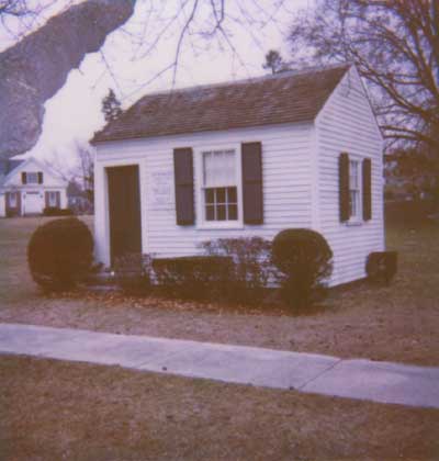
The Middlesex Canal Toll House (photo by Bill Gerber)
weeds and brush - a reminder of past greatness when the industrial revolution was just starting in New England, and more efficient transportation was needed to move the produce from the area north of Boston to the waiting commercial market there.
Railroads were as yet unheard of. The Middlesex turnpike provided only a slow expensive method of getting goods to Boston Market. Canals, common in Europe and becoming recognized in this country as an ideal way of expanding the economy, were the answer, and a dedicated group of men had begun the building of this canal to supplant the highway as a better method of moving goods to the Boston port from whence they would move into world markets.
This small weatherworn building had been the office of collector of tolls for this new canal. It stood near the river bank, where boats going up the Merrimac river through Nashua, as far as Goffstown and Manchester N.H., operating with sails and pole-men brought produce which was here transferred to the packet boats of the Middlesex canal, which whisked it on down to Boston. Here in this once busy toll house had been collected the tolls essential to the maintenance of and operation of the canal.
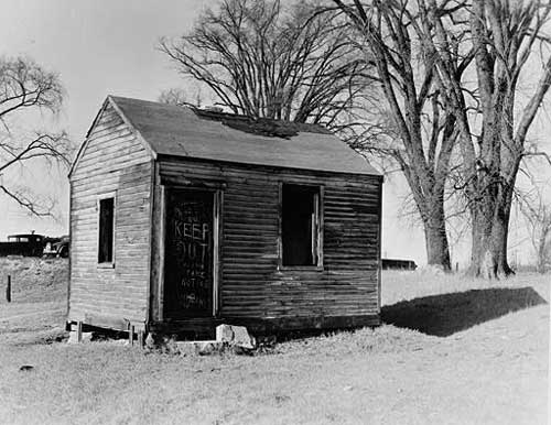
Early photo of the tollhouse in decline
One of the keepers of the Toll House, working dailey [sic] to collect the tolls which were essential to the maintenance of the Canal was Judge Samuel T. Hadley. Judge Hadley's widow lived on Middlesex Street in Middlesex Village within sight of this monument to past greatness, and it troubled her that it was deteriorating and soon vandalism would completely destroy it. She talked about this to a neighbor, a Mr.Ryan, a man who loved horses and whom I had remembered seeing driving around the country roads in a training sulky. Mr. Ryan was a public spirited person, interested in preserving monuments to past greatness now about to be obliterated by modern growth. The old tavern building had become an automobile agency, the boarding house where canal employees lived when not on duty had been converted into rental housing units, and across the canal there was now a livery stable and a riding school.
Acting on behalf of Mrs. Hadley, Mr. Ryan began to explore ways in which the Toll House structure could be saved. The location had so badly deteriorated that it did not seem intelligent to restore it on its original location. Mr. Ryan knew of my interest in the preservation of historic buildings and came to me and asked for advice and ideas. At about this time I had purchased the land and buildings adjoining the property of the Wm. P. Proctor Lumber company of which I was the principal executive officer. These were difficult days of the depression. The economy, which had been at a virtual standstill, was beginning to show signs of life. I was busy trying to build a retail lumber business to replace a wooden box business, which had been outmoded with the advent of corrugated cardboard packing cases, but the wooden box business was employing upwards of 100 people who could not have found employment elsewhere because of the still faltering economy, so I did not have money to spend on a nonconnected venture, worthwhile as this one was.
Still I did have in the newly purchased land a prime location where the building could be safe, and where directly across the street from the busy Catholic church it could be available for inspection by interested citizens. I offered this location to Mrs. Hadley who enthusiastically endorsed moving the Toll House.
Mr. Ryan cooperated. He arranged a horse drawn vehicle with a platform underslung between some large wheels. Granite from the old location and elsewhere was put in place as a foundation and the Toll House was in its new location. Clapboard siding was missing in places, and this we at Proctor Lumber restored. The original clapboard siding was interestingly different from that available on the market. Now, the new clapboards have square ends which butt up against the next square end, but on the old Toll House the ends of the clapboards were tapered off to a feather edge and the next one lapped over, since its ends were also tapered. Mr. Carrol Craft, an employee of the Proctor Company, did the required restoration work inside and outside, and then it was painted to preserve it and give it back its original appearance. A poster was put inside telling a bit of its history. Hundreds of interested people stopped to inspect it. We had a simple ceremony rededicating it when it was opened to the public.
The Toll House, by now generally recognized as an authentic symbol of Chelmsford’s early development, made its next journey, at the time of the celebration of Chelmsford’s tercentenary of it's founding. The committee planning the celebration thought that it was fitting that the old Toll House should be one of the central attractions of this celebration, and it was moved to the lawn of the Town Hall in Chelmsford Center and served as an information booth as well as an image of past glories. After the celebration it was moved to a new location in a corner of Forefather’s Cemetery, just across the village common from the Town Hall. There it stands now waiting the time when a part of the Canal can be restored in Chelmsford in a suitable park like image, as a more fitting recognition of its historic value.
NORMAN P. MASON 1977
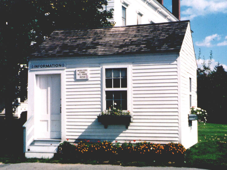
Another view of the tollhouse (at a different location!)
To continue the story near where Mr. Mason left off:
In May 1955 the Hadley heirs sold the building to the Town of Chelmsford. It was brought back to the Town Hall lawn in June 1975, again to serve as an information booth. However, a year and a half later some of the selectmen were getting restless over its location, even calling it a “shack.” Compromises were made, and in 1980 the Park Department agreed to move it a few yards away to a location on the Common, across from the fire station. There it remains today.
CANALS OF THE
MERRIMACK RIVER
by William E. Gerber
At the fall meeting of the MCA on November 4, 2001, Proprietor and Board of Directors member Bill Gerber described some of the results from his continuing research into Merrimack River canals. The talk centered on a fairly extensive display of photographs and sketches of the various historic canal sites, all arrayed along an extended topographical map of the Merrimack between Lowell MA and Concord NH. The photos and sketches were keyed to specific points on the map corresponding to where each of the original canals was located.
Some of the aerial photographs, taken at a time when there was little water in the Merrimack downstream of Manchester NH, provided surprisingly detailed pictures of the visible remains of seven canals; i.e., Cromwell’s and the six Union Canals. These and various portions of their associated structures, e.g., parts of some channels and dams, were clearly discernible. Additional photographs, taken during canoe trips and other site visits, provided close up views of portions of the sites as they are today. Two other sites, Wicasee Canal and the lower Nashua River Canal, were also photographed from the air but no canal related structures were observed. The photographs were augmented by a collection of drawings and sketches, copied from historical documents and the writings of others, that shed still more light on the early structures.
Among those attending the presentation was Mr. Charles Mower, cabinetmaker of Merrimack NH, who is also an authority on the Merrimack River canals. Mr. Mower made a related presentation to the MCA several years earlier and contributed to this one as well. Following the lecture, Mr. Mower presented the Middlesex Canal Museum with an indefinite loan of several items of historical interest - a steering oar, a pike pole, a section of chain, and a cribbing spike - all dating back to the time when the Merrimack River Canals were operating.
The Pawtucket and Lawrence Canals, both of which are down river from the head of the Middlesex Canal, were not part of the Middlesex and Merrimack River transportation corridor and thus were only briefly mentioned. These incorporated 11 locks, later reduced to nine, between sea-level and the level of the Merrimack above Pawtucket Falls. These two canals generally supported the shipbuilding industry in the area of Newburyport. Similarly, the canals of Lowell, primarily power canals and not transportation canals, were built later and so were also not discussed.
By about 1815, upstream of the head of the Middlesex Canal at Middlesex Village in Chelmsford (Lowell did not yet exist), a total of twelve canals incorporating 25 locks had been constructed at significant rapids and falls along approximately 51 miles of the Merrimack River and its Piscataquog tributary. Yet another canal with four locks was completed in about 1826 near the mouth of the Nashua River, providing access to the Nashua River above the dam (near the present day Margarita’s Restaurant) to serve the Nashua Manufacturing Company. These were all part of a transportation corridor between Boston MA and Concord NH that operated during the first half of the nineteenth century. The Middlesex Canal served as the southern third of this corridor. This complex carried commodities and merchandise for about forty years, during those months of the year that the canals remained ice free.
Perhaps the best way to describe this transportation resource is to describe a hypothetical trip up the Merrimack River as it might have occurred in the “heyday” of the canals. (Bill began his talk by attempting to do this but became somewhat sidetracked by audience questions and comments.)
To help the audience visualize the scope of the task of operating a freight boat, Bill had laid a strip of tape on the museum floor to show the size of the boats. These were not the dainty little boats depicted in many of the articles and books that have been written about the Middlesex Canal. The length of the largest boats (70' x 9.5') would have extended from the wall at the front of the museum all the way through both the display and meeting rooms to the back wall, just before the kitchen area. In width, they would have occupied about a quarter of the width of the meeting room.
Consider that the year is 1823 and a crew of three men employed by the Boston and Concord Boating Company (newly the successor to the Merrimack Boating Company) has taken a boat loaded with 15 tons of goods from Boston to Concord. Typically, this journey took 5 days to complete, though some claim to be able to do it in 4. Assume, however, that our crew took the five days. Our boat was allowed to travel at 2.5 miles per hour and, rule-of-thumb, it took about as long to negotiate one lock as it took to travel one mile. At this rate, our crew progressed through a combination of about 25 to 30 locks and miles in a 10 to 12 hour work day. And so, the first day and half or so of the second were spent ascending the 27 miles and 17 locks of the Middlesex Canal, from Charlestown to Middlesex Village (later a part of Lowell). Throughout this part of the journey, the boat was pulled by a single draft animal, likely a horse or mule that was left stabled at Middlesex Village when our crew began the river portion of their journey.
The latter half of the second day included completion of the remaining distance on of the Middlesex Canal and a descent through the three stone locks at Middlesex Village, dropping from the summit level (i.e., the level of the Concord River) about 24 feet to the level of the Merrimack River above Pawtucket Falls. A boat basin at the bottom of these locks provided space for boats coming down from Concord and other points to await their turn to ascend these same locks, and for Concord-bound boats to adapt their “means of propulsion” for river travel.
The next task for our crew was to proceed across the river to the opposite bank. It may be that the boats were rowed across the Merrimack, but it seems more likely that they were pulled across, hand-over-hand, using a fixed line. This would have been similar to the fixed line that was used to move boats between Charlestown and Boston. (Though not yet found, a very large boulder with an iron ring in it, which can only be seen at low water, has been reported in the vicinity of the basin at Middlesex Village. Conceivably, this boulder might have anchored the southern end of the fixed line.) Along its length, this line would have been weighted so that it normally rested at least several feet below the surface of the Merrimack, thus enabling other boats and rafts of logs, those traveling to the new Lowell mills or continuing down to Newburyport, to pass over it when it was not in use.
Upon arrival at the opposite bank our boat might have been steered into a channel formed by a berm that appears to have been constructed parallel to the bank and extends for a half-mile up river (roughly from the area of the present-day Community Boating House to the Lowell Water Works). The water level in this channel was the same as that of the river but would have kept ascending boats out of the river currents thus facilitating their up-river progress. (Though no mention of this channel has yet been found in the historical record, remnants of this channel can still be seen from the Roark Bridge and from the air.) Here too, the boats were probably rowed or poled the length of this protected channel. Boats descending the river would likely have remained in the middle of the river so as to take advantage of the river current.
Rowing a 70' freight boat was not a trivial exercise. The oars were so long, and the boat so narrow, that the crewman whose oar extended from thole pins on the right side of the boat actually rowed from a position near the left side, and vice-versa.
Setting-poles (aka pike poles) provided another means of propulsion. To rig for poling, cargo was placed in the boat so as to leave a narrow passage adjacent to each gunwale from the bow to the mast-thwart. There was also a clear space of six to ten feet left at the bow, and enough at the stern to allow a bow sweep or the tiller to be moved freely across the boat. To propel the boat forward by poling, a man stood on either side of the bow, facing the stern, and thrust the end of his pike pole down beside the boat, in a slanting direction towards the stern, until it struck the bottom of the river. He then placed his shoulder against the top of the pole and, with his feet firmly braced against the cross-timbers in the bottom of the boat, he exerted the strength of his body and legs to push the boat forward. As it moved, he stepped along the bottom of the boat, still bracing his shoulder firmly against the pole, until the movement of the boat had brought the mast-thwart to him. He then walked back to the bow, trailing his pole in the water, and repeated the pushing movement.
At the end of the channel, our crew rowed or poled the boat the remaining two miles along the bank to and through the passage between Tyngs Island (now home to the Vesper Country Club) and the east bank, to the Wicasee Lock. (This was the only river canal and lock constructed completely by the Middlesex Canal Company.) Here, the boat was lifted approximately three feet, in a single lock, to a level set by a dam that extended across the Merrimack from Tyngs Island to the west bank. This was about as far as our crew traveled by the end of the second day. (Both remains of the lock on the east side of Tyngs Island and parts of the dam on the west side can still be seen, but only when the river level is very low.)
Beginning the morning of the third day, from the top of Wicasee lock, our crew rowed or poled the boat the remaining short distance to the end of the channel. Most probably, the crew continued to row or pole the boat for the next 15 miles up the Merrimack River to Cromwell's Lock. If the wind was out of the south, it is also possible that they could have rigged a sail and taken a more leisurely trip up that stretch of river. Likely, this didn't happen very often. (En route, our crew would have passed the future site of the Nashua River Canal; however, this canal would not be completed for another three years.)
But, there is another possible way in which our crew may have made the journey from Wicasee to Cromwell’s: they might have been towed by a steam tugboat. The historical record indicates that a steam tugboat was launched in 1823, the year that the Merrimack Boating Company was sold and became known as the Boston and Concord Boating Company. It seems likely that this new tugboat would have added to those built by the earlier firm. (I.e., at least the two for which records have been found.) The first of these, employing a “chain of floats” drive (perhaps like a caterpillar tread), had been launched in 1811. Another, the “Merrimack”, a side-wheeler powered by a Morey engine, was launched in 1818. And a stern-wheeler was launched in 1823. Were there others? There may have been. In any event, it seems reasonable to assume that a steam tugboat could have been used to tow our boat and crew from Wicasee Lock to Cromwell’s Lock, perhaps beyond and possibly all the way through. (But then, it would not have taken them five days to complete the trip and that wouldn't fit this story!)
The first lock reached in New Hampshire, Cromwell's Lock was located on the west side of the river. (The site, just downstream of the Budweiser Brewery in Merrimack NH, is the best preserved of all of the historic canal sites.) Here our boat was lifted about six feet in a single lock.
Cromwell's may have been the first lock encountered, ascending the river that used a different type of lock gate, known as a drop-gate (though it is possible that this type of gate was also used at Wicasee). It appears that drop gates were used here and at each of the seven locks of the Union Canals. In the more familiar miter gated locks, two miter gates (at each end of a lock) are swung from their closed position (with the mitered end facing upstream) into recesses in the sides of the lock, so as to allow space for a boat to pass by them unimpeded. In contrast, in a drop gate lock, a single gate (at each end of the lock) rotates down into a recess at the bottom of the lock so that a boat can pass over it, equally unimpeded. In the case of either gate type, additional channels and controls are still needed to admit water into the lock from the upper level of the river to raise a boat, and to discharge it from the lock to the lower river level to lower a boat.
The river level on the upper side was set by a long channel constructed of stone blocks and a cribbed stone dam that extended from the upper end of the channel east across the river, at the top of the rapid. (As with all other sites, the dam here would have created a slack water pool that extended all the way upstream to the next lock.) Once locked through and out of the channel, our crew rowed or poled the boat another four miles to Moor's, the next upstream canal. It is also conceivable that the steam tugboat might also have locked through and towed our boat there. But if left to their own devices, Moor's was about as far as our crew traveled by the end of the third day.
The next six canals, all built by the Union Canal Company, were completed by about 1815. They bypassed an equal number of rapids and small falls found along the next nine mile stretch of the river, ending just south of Derryfield (now Manchester). It seems likely that most boats, if not all, would have been poled between each of these canals and may have been poled through some of them. It also appears that draft animals were sometimes used to assist them.
Moor's Canal was located on the east side of the river. It seems certain that the engineering for this canal was slightly more complex than for most of the other sites. Like the others, it was built to enable boats to bypass a small waterfall. Unlike any of the other Union Canals, though, it incorporated two locks, spaced a short distance apart, to raise boats about six feet total. The space between these two locks, i.e., the middle level, was not very long and would not have contained a sufficient volume of water to both completely "charge" the lower lock and still remain navigable. Thus, some means would have been needed to fill either this middle level or the lower lock, or both, from the upper river level, and to weir off surplus water when the upper lock emptied into a full middle level channel. (And indeed, aerial photography suggests the existence of several channels at this site.)
Our boat accessed the lower lock directly from the river. It probably was assisted through this canal and its locks by draft animals. These would have helped to move the boat into each of the locks, from lock to lock, and to the end of the canal channel that extended upstream from the upper lock.
Suppose that another craft (e.g., a raft of logs or another boat) was descending from the bottom of the upper lock as our boat emerged from the top of the lower lock; how would they have passed? There are several descriptions of the tow line of one boat being passed over the other craft; but this would have been cumbersome and even dangerous. A better and more probable way would have been for our boat to steer to the berm side of the channel, for our draft animal to move to the outside of the towpath, and thus for our tow line to be made slack so that it would sink to the bottom of the channel. This done, the descending craft easily floated over our tow line while passing between our boat and draft animal. This would be simple and quick, no tow line would be detached, and no person or cargo would be swept into the channel by an overhead tow line suddenly made taut. This same procedure would also be used when a faster boat, e.g., a packet, overtook a slower craft, both traveling in the same direction.
Emerging from the upper lock, our boat was towed a short distance to the end of the upper channel before returning to the river. Once again underway. our crew rowed or poled the boat about a mile to the next lock, known as Coos or Cohas.
Coos/Cohas canal was located on the west side of an island that was adjacent to the east bank of the river; the width of the river at this point being somewhat constricted by the island. Thus it appears that this lock and channel were almost in the middle of the river. The canal was a relatively short one, incorporating a single lock accessed directly from the river. The lock provided a lift of about three feet. Emerging from the top of the lock, our boat was towed a short distance within the upper channel before being returned to the river. (Aerial photography suggests that the dam probably extended at an angle across to the west bank of the river, from about where the lock and upper channel joined. The channel between the island and the east shore would also have been dammed. Little evidence remains of either.) From Coos/Cohas, our crew rowed or poled another mile or so upriver to the next canal, Goff's.
At Goff's, the lock and the channel above it were located on the west side of the river. (The lock remains are immediately downstream of a present day railroad bridge, with the dam remains being just upstream of the bridge.) Both the channel and the dam were constructed partially of cut stone and partially of cribbed stone. The dam ran in a somewhat serpentine path to the eastern shore. Goff's lock was a moderately high one, providing at least six feet of lift, perhaps more, to raise boats above a high ledge. Like other Union Canal locks Goff's used drop gates. Once through this lock, our boat followed a channel constructed partially of cut stone and partially of cribbed stone along the west shore until clear of the dam and several islands.
Upstream, the next canal was Griffin's. Located along the eastern bank of the river, this canal was relatively short and incorporated a single lock with drop gates. Likely the dam was constructed of a combination of cut and cribbed stone. It extended across several islands immediately to the west of the canal and lock. Here our boat was probably lifted only two or three feet. (The remains of this canal are visible a very short distance downstream of the present day Route 293 bridge, south of Manchester. Today, the lock is clearly recognizable, however it has been filled in with cut stones apparently fallen or sheared from the upper levels of the lock together with other debris and vegetation. A few years ago, the upstream end of the lock was destroyed when a sewer line was laid across the river at this location. Except for some pin holes in the nearby ledge and bits of cribbing on the west shore, there is almost no trace of the dam.)
From Griffin’s it was about another mile to the next canal, Short’s. Also located along the eastern shore, this canal was somewhat different from the others in that it had relatively long approach channels both downstream and upstream of the single lock. There was a basin along the eastern shore midway in the lower approach channel where our boatmen could have awaited their turn to enter the lock. A “funnel shaped” extension of the upper channel likely served the same function for descending boats. This lock was relatively high, capable of lifting our boat about 7 feet. (This appears to be the second best preserved lock on the Merrimack. Regrettably, 20 or so years ago, its outer wall was quarried for cut stone and so it is no more than half of the height of the shore-side wall. There are two possible paths that could have been used for the dam. Which was used is not apparent from the aerial photography.)
Back on the river above Griffin’s canal our crew again poled a mile or so to Merrill’s the uppermost of the Union Canals. This canal incorporated a single lock, accessed directly from the east side of the river, which raised our boat only about three feet. Emerging from the lock, our crew negotiated a third-of-a-mile channel before returning to the river. It appears that the dam extended from the farthest upstream end of this channel diagonally to the western shore. (This canal can be seen on the east shore of the river almost under and upstream of the Granite Street Bridge in Manchester. It can be accessed from the Union Leader Plaza at the southern end of the mill immediately to the north of Granite Street, on the east side of the river, with more of it visible from the parking lot at the north end of the same mill. Nothing remains of the lock, it may have been quarried for the abutments of the bridge; certainly there is an abundance of cut stone to be found in the eastern abutment. Similarly, little remains of the dam; likely it was constructed of cribbed stone throughout its entire length.)
From the upper end of the Union Canals the character of travel changed. Ignoring the canal and two-lock staircase at the mouth of the Piscataquog River, which provided access to the town above the mouth of that river (not in our line of travel), there were only three more Merrimack River canals to negotiate. But these incorporated a total of 14 locks, all of which were probably miter gate locks.
The next canal that our crew came to was Amoskeag, known earlier as Blodgett’s Canal. This canal was about a mile and a third in length and incorporated a guard lock and six lift locks to bypass the 54 foot falls at Derryfield (now Manchester). From the bottom, this canal began with a channel, accessed from the east side of the river, that led first to a staircase of four locks. Because it was not possible for boats to pass in the middle of a staircase, the passage of boats through this flight might have been time-regulated, allowing some number of boats to pass in one direction before changing to allow passage in the other direction. Once at the top of the flight of four, our crew poled or rowed about a half-mile to the next locks, a two-lock staircase. Passing out of the upper level of this two-lock flight, they proceeded another half mile to the guard lock. Exiting the guard lock brought them back to the river above the dam. This was as far as our crew managed to travel by the end of the fourth day. (Based on a survey by Alden Gould, the canal channel was still more or less intact in 1975. Heavy granite walls still stood in very good condition. However, the only remaining lock, the upper guard lock, is located at the Amoskeag Dam. It was built of cut granite and appeared to be in fine condition. Its north end is sealed off by concrete but the lower gate recess is clear, though without gates. A latter day gate house, of brick construction at the end of the 75-foot flume, is sealed off with concrete at the canal’s lower level.)
From this point, beginning in the morning of the fifth day, our crew continued to row or pole their way for another eight miles to Hookset Canal. (Alternatively, they may have been towed between these upper canals by a steam tugboat.) Hookset Canal consisted of a guard lock and two lift locks in a very short channel on the west side of the river that by-passed a 16 foot falls. Emerging from the guard lock, our crew was back on the river. From here they made their way another seven miles to Garvin’s Fall Canal. (In the late fall, sections of some walls can be viewed; however ice floes have damaged much of the site.)
Garvin’s Falls, also known as Bow Canal, was on the east side of the river. It consisted of a channel with a guard-lock and a staircase of three lift locks, together with a 450-foot wood and stone dam. These may have been the deepest lift locks in the system; it appears that each raised or lowered boats about ten feet. Here our boat was lifted about 30 feet overall, high enough to pass over the next upstream obstacle, Turkey Falls, which extended another 5 feet above the upper level of Garvin’s Falls (i.e., Turkey Falls, about a mile further upstream, was flooded out by the waters above the Bow Canal dam).
(Apparently the flume of an old electrical substation on that site was the canal. Gould claims that the exit of the canal can be seen on the west side, which is watered, back to the granite abutments of the old dam. It may be that some of the upper end of the canal was covered over or removed when a second railroad track was added to the original single track.)
By the top of the Bow Canal, our boat had been lifted a total of about 135 feet above the level of the Merrimack River at Chelmsford. From here our crew had only another four miles to go, all at the same level, to reach Concord where they probably arrived in the late afternoon or evening of the fifth day. At Concord, the Boston and Concord Boating Company maintained two water-side warehouses, one on the west side of the river near the bridge, the other on the east side near the upper bridge. It seems likely that the boat would have been tied up for the night and then unloaded the day after arrival.
And on the seventh day they rested!
The Middlesex Canal Association has set up a Memorial Fund to honor the memory of Burt VerPlanck. The fund has now received more than $1000. Contributions to the fund are welcome. Please send any contributions to our treasurer, Howard Winkler, at 10 Sleepy Hollow Lane, Arlington, MA 02474.