
Middlesex Canal Association P.O. Box 333 Billerica, Massachusetts 01821
www.middlesexcanal.org
| Volume 53 No. 3 | March 2015 |
MCA ACTIVITIES
Please mark your calendars.
MCA and friends will sponsor a bicycle tour of the canal, south from Lowell, on Sunday, April 12th.
The MCA-AMC Spring Walk will take place on Sunday, April 26th.
Our Annual Meeting will be held on Sunday, May 3rd, 2015, in the museum, beginning at 1:00pm.
See the Calendar, following, for more information on our activities. Also included are meetings and tours, sponsored by other canal and related organizations, in which you may want to participate.
Please also check our web site now and then, at the URL noted above in the nameplate, which also lists canal-related events and topics of potential interest, sometimes including those that don’t make it into Towpath Topics.
TABLE OF CONTENTS
President’s Message (J.J. Breen)
Calendar of Events
For Future Planning
Boston - Here We Come (Betty Bigwood)
Title Track of a Broken Record (Marlies Henderson)
Passing the Baton! (Bill Gerber)
Miscellany
PRESIDENT’S MESSAGE
by J. Jeremiah Breen, President; jj@middlesexcanal.org
The Sunday, April 26, walk from the visitor center/museum south stops at the pair of iron rings, 4’ apart, used to chain the floating towpath to the west bank of the summit pond. The location of the iron rings aside the existing canal is a good place to start talking about the history of the canal as the ceremonial groundbreaking was there September 10, 1794. The prayer at the groundbreaking,
“May the Eye of Wisdom and the Eternal Mind aid this work designed for the benefit of the present & all Future Generations”
is still efficacious with the present generation which has an active, beneficial Middlesex Canal Association 220 years after the future began for what the generation of 1794 prayed.
The rings on the east side of the summit pond have not been found, but are likely part of the timber crib now underwater at the end of the causeway. See Crib Dimensions, below.
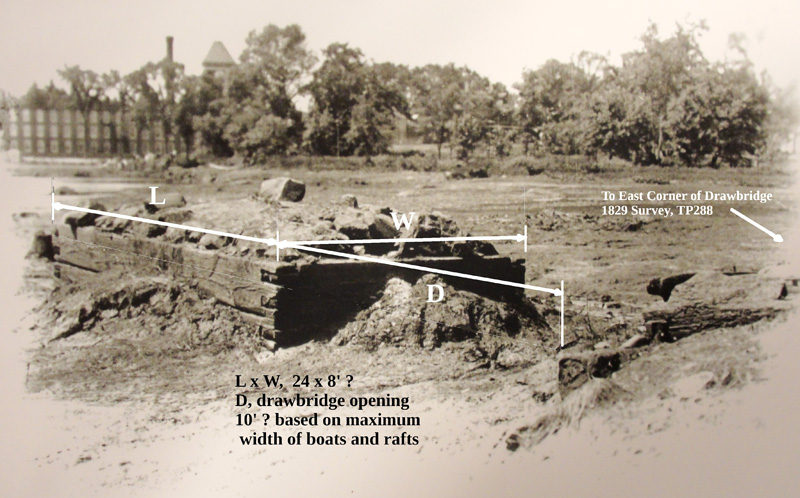
Crib Dimensions
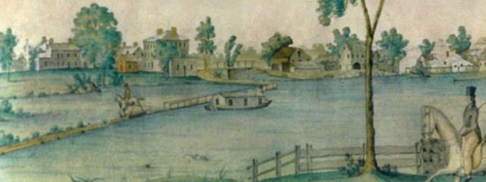
The level of fill in the crib is roughly 6” below the top of the 1825 iron bolt which is the benchmark for the water level in the summit pond. The towpath length between the iron rings on the west side of the summit pond and the east end of the drawbridge was 6 chains, 92 links, or 457’, based on George Baldwin’s 1829 survey. This length can be seen in Jabez Barton’s watercolor, thought to have been done when he was courting Rebecca Rogers, who married him in 1822. See detail from Barton’s Floating Towpath, so called, below.
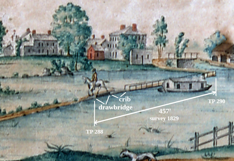 |
| image credit: Jabez Ward Barton, 1822 |
| Floating Towpath, compliments of the Billerica Historical Society Summit pond, 109.64’ above Charles River, 1929 Sea Level Datum |
The 1807 Rogers House is aside the canal where the April 26 walk crosses Rogers Street and enters the woods, leaving the summit pond behind.
The floating towpath was found ca. 1930, though the Leon Cutler lantern slide recording the find doesn’t say where. See “Floating Towpath, Found!”. The view in Cutler’s slide could be from the east bank of the timber cove extension of the summit pond looking west across the timber cove.
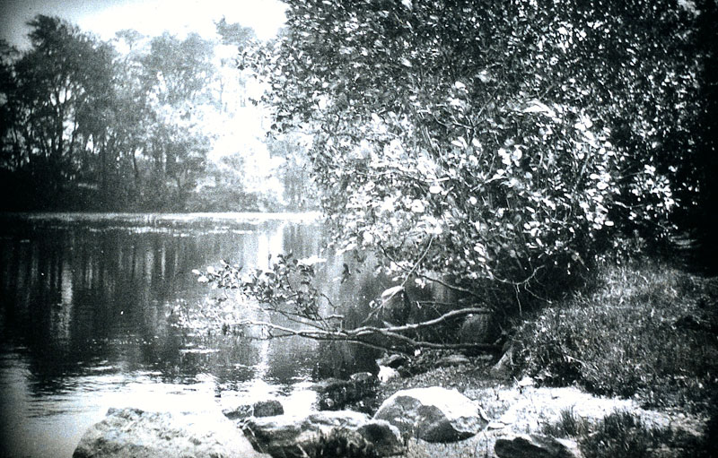 |
| Photo from the Leon Cutler Collection |
| Floating Towpath Found! |
In the figure “Towpath Section Found,” below, Google Earth shows an unnatural straight line in the August 2013 image of the timber cove which might be formed by the floating towpath, sinking when its barrels(?) leaked, its 400 or so feet divided in two when it was put into the cove for winter storage after the last boat passed November 25, 1851.
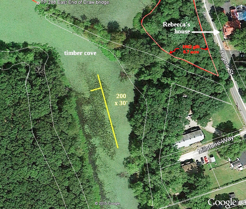
Towpath Section Found
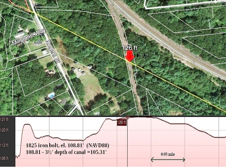
The April 26 walk crosses Rogers Street and enters the woods where ATVs have kept the former Toothaker Street passable to the railroad. The single track is in the right of way of the 1877 Billerica & Bedford RR, the first 2’- gauge railroad in the United States. Toothaker Street led in 1875 to the Talbot Chemical Works, a multi-building factory complex between the canal and the mainline Boston & Lowell RR north of the canal.
 |
| Image credit: Google Earth |
| Deep Cut at Bedford & Billerica Railroad |
The deepest, hardest excavation of the canal was here where the railroad is now. See Deep Cut at Bedford & Billerica Railroad, above. The high ground with sub-surface granite is the dividing line between the Concord and Shawsheen River basins. The NY state officials for the Erie Canal who visited the Middlesex Canal reported in 1817 “the canal passed through half a mile of deep cutting, 800 feet of which was through hard granite which had to be blasted. Some places had to be blasted 7 feet deep, and 14 to 20 feet wide. The cut for this half mile was from 12 to 20 feet deep.” 1
Drilling a hole in granite using a star chisel and hammer, then using gunpowder in the hole to break the granite, is extraordinarily slow and expensive. In 1796 it was voted,
“That where the depth of Cutting shall exceed Eight feet - the bottom of the canal shall be only Ten feet broad.” 2
In the consulting engineer’s report to the canal company directors on August 2, 1794, William Weston wrote:
“I have fixed the surface of the water on the summit level of the canal one foot higher than the dam at Richardson’s mill, this being as much as could be done with safety to the range of Meadows which extend for miles on each side of the Concord. The Length from Richardsons Mill to the Merrimack is Five Miles, Three furlongs, and Six chains; and the fall Twenty-four feet, six inches.” 3
However, an advertisement in 1803 stated
“The proprietors --- notify the public that the Canal is completed. Boats ascend from Merrimack at thirty miles distance from Boston, to an elevation of twenty six feet above that river, through three Locks.” 4
Rather than blast granite deep, the directors raised the Concord River. The raising beyond the consulting engineer’s recommendation would have been a smoking gun for the meadow owners had they known of it when they claimed to have been damaged by the dam. But an 1861 engineers’ report showed that the Billerica Falls Dam was not the cause of flooding on the Concord River meadows. See “The 1825 Iron Bolt and the Great Billerica Dam Controversy”, http://middlesexcanal.org/towpath/towpathtopicsSept2013.htm.
Loammi Baldwin (1744/45 - 1807), builder of the canal, had surveyed the canal route with Weston in 1794. When he re-built the dam in 1798, he included 24” flashboards, probably preparing for lowering the dam if necessary. See “Plan of the North Billerica Dam” by Hiram F. Mills with 1.95’ from the 1862 legislative hearing on the 1861 Engineers’ Report.
J. Jeremiah Breen
References:
1 Lewis Lawrence, The Middlesex Canal, 1942, p. 118.
2 Op. cit., p. 105
3 Mary Stetson Clarke, The Old Middlesex Canal, 1974, Appendix 2
4 Lawrence, op. cit., p. 32
CALENDAR OF EVENTS
Middlesex Canal Association (MCA) and Related Organizations
The Middlesex Canal Museum and Visitors’ Center is open every Saturday and Sunday, noon-4, except holidays.
First Wednesday - MCA Board of Directors’ Meetings - The Board meets at the Museum, from 3:30 to 5:30pm, the first Wednesday of every month, except July and August. Members are always welcome to attend.
Directions to the Museum/Visitors Center: Telephone: 978-670-2740.
By Car: From Rte. 128/95, take Route 3 toward Nashua, to Exit 28 “Treble Cove Road, North Billerica, Carlisle”. At the end of the ramp, turn left onto Treble Cove Road toward North Billerica. At about ¾ mile, bear left at a fork. After another ¾ mile, at a traffic light, cross straight over Route 3A. Go about ¼ mile to a 3-way fork; take the middle road, Talbot Street, which will put St. Andrew’s Church on your left. Go about ¼ mile and bear right onto Old Elm Street. Go about ¼ mile to the falls, where Old Elm becomes Faulkner Street; the Museum is on your left and you can park across the street on your right, just beyond the falls.
From I-495, take exit 37, N. Billerica, south to the road’s end at a “T” intersection, turn right, then bear right at the Y, go 700’ and turn left into the parking lot. The Museum is across the street.
By Train: The Lowell Commuter Line runs between Boston’s North Station and Lowell’s Gallagher Terminal. Get off at the North Billerica station, which is one stop south of Lowell. From the station side of the tracks, the Museum is a 3-minute walk down Station and Faulkner Streets on the right side.
Walks along the Delaware & Raritan Canal in New Jersey. Various weekends. These walks are sponsored by the D&R Canal Watch. For additional information contact Bob Barth at 201-401-3121 or bbarth@att.net.
Sat, March 28 – D&R Canal Watch 5K Fun Run, Washington Crossing State Park. For more details, visit our website, www.canalwatch.org.
Sat, April 18 – 10:00am. Hike 6.2 miles from Washington Crossing to Ellarslie, the Trenton City Museum in Cadwalader Park (the meeting place) or choose the 2.4-mile walk to Scudder’s Falls. The tour will pass by Wilburtha and Upper Ferry Road and will include historic canal structures: several stop gates, a spillway, an aqueduct, and other historic features. Leader: Pamela V’Combe, 609-635-2783.
Sun, April 19 – 1:00-3:00pm. Explore the Abbott Marshlands and learn about Charles C. Abbott, naturalist, doctor, and archeologist. 157 Westcott Avenue, Hamilton. $5 per person. Group is limited to 20 people. Register by contacting Bob Barth, 201-401-3121; bbarth@att.net.
Sat, May 2 – 10:00am. Hike 4.5 miles from Whitehead Road to Ellarslie, the Trenton City Museum in Cadwalader Park (the meeting place) or choose the 2.5-mile walk to the Trenton Battle Monument. Questions? Contact Bob Barth at 201-401-3121 or bbarth@att.net.
Weekend, April 10-12, 2015. Canal Society of Indiana. “Fruhling Kanal Ausflug mit Freuden” - The Spring Tour of the Canal Society of Indiana will have a German theme as it explores the Wabash and Erie Canal in Jasper and Dubois Counties. The tour will be based in Evansville, Indiana, see http://www.canadiancanalsociety.org/documents/2015-04a-csi-spring-tour.pdf for details.
Sun, April 12, 2015. Middlesex Canal Association’s Spring bicycle tour. Meet 9:30am at North Station (commuter rail) and take our bicycles on the 10am train to Lowell. Riders meeting the group at Lowell meet at the train station at 10:40am. This year an early group will take the 8:00am train from North Station to allow more time in Lowell and breakfast at the historic Owl Diner (www.owldiner.com, aka the Four Sisters).
Route visits the Pawtucket and other Lowell canals, the river walk, Francis Gate, and Middlesex Canal remnants in Chelmsford. Lunch at Route 3A mini-mall in Billerica. Quick visit to Canal Museum, then on to Boston. A long day of exploration (35 miles end-to-end) but sunset is late.
Riders can board northbound trains at other stations or catch southbound trains at 1:07pm or 3:14pm to return to Boston early. Complete Lowell line schedules can be downloaded at http://www.keoliscs.com. Participants responsible for one-way train fare [$9.25 from Boston to Lowell]. For changes or updates, see http://middlesexcanal.org. Leader Bill Kuttner (617-241-9383).
Sun, Apr 19, 2015. Canadian Canal Society. The Annual General Meeting. See http://www.canadiancanalsociety.org/events.html for more information.
Weekend, Apr 24-26, 2015. Joint Pennsylvania and Ohio Canal Societies’ tour of the Beaver Division of the Pennsylvania Canal. The annual meeting of the American Canal Society will be held in conjunction with this event. The day long tour will run along the Beaver and Shenango Rivers between Rochester, PA and Sharpsville, PA. HQ: Hermitage Quality Inn (3200 S. Hermitage Road, West Middlesex, PA 16159). Steve Fritz of the U.S. Army Corps of Engineers will speak on Friday evening, April 24th about planning navigation improvements on the upper Ohio and lower Monongahela rivers. Saturday speaker, John Kokoski of the Greenville Canal Museum. For more information contact Dave Wright (wereallwright@gmail.com). Register through http://pacanalsociety.org.
Sun, April 26, 2015. Joint MCA-AMC Spring Middlesex Canal Walk. Meet at 1:30pm at the Middlesex Canal Museum and Visitor Center in the Faulkner Mill in North Billerica. The walk will be for 2-3 hours, rain or shine, over generally level wooded terrain and streets. The route follows the canal for a round trip of under 3 miles south of the Concord River. Sites to be visited include: two guard locks; an anchor stone and the ‘peninsula’ at the opposite ends of the floating bridge that once carried the towpath across the Concord; the 1825 iron bolt pond-level reference; the “deep cut”; a smallpox memorial marker; stretches of canal some of which are still watered; and possibly the impending photovoltaic facility on High St. The Museum and bookstore will be open from 12:00pm-4:00pm. Phone 978-670-2740. L Robert Winters (617-661-9230; robert@middlesexcanal.org), CL Roger Hagopian (781-861-7868 to 10pm), CL Marlies Henderson.
Sun, May 3, 2015. Middlesex Canal Association Annual Meeting will be held in the museum, beginning at 1:00pm. Our speaker, Marcis Kempe, has as his topic, “Boston’s Water Supply and the Middlesex Canal”, based on Caleb Eddy’s Historical Sketch of the Middlesex Canal, 1843, which can be read at http://tinyurl.com/eddy1843. Refreshments will be served.
Weekend, Jun 5-6, 2015. This New York and Canadian Canal Societies tour will examine the pre-Seaway canals along the St. Lawrence River and will be based in Cornwall, Ontario.
Weekend, July 24-25, 2015. Parks Canada Celebration of the 100th Anniversary of the opening of Lock 45, Port Severn. Details to be posted to http://www.canadiancanalsociety.org/events.html as they become available.
Weekend, Sept 7-10, 2015. World Canals Conference, Ghent, Belgium. Conference will include boat trips on Ghent’s inland waterways and the Port of Ghent, and visits to the project of Waterways & Seacanal and Flanders Field. www.wccghent2015.com.
Weekend, Oct 16-18, 2015. Pennsylvania Canal Society tour of the Northern Schuylkill Navigation.
Sun, Oct 25, 2015. Middlesex Canal Association Fall Meeting at 1:00pm in the Reardon Room of the Visitor Center/Museum. James Baldwin will give a talk about his many-times-great grandfather Loammi, builder of the Middlesex Canal with images of some of the family artifacts. These include an invitation to dine from Washington to Loammi dating from the days immediately following the Battle of Lexington and Concord, where Loammi led the Woburn militia at the “Bloody Angle”. Loammi was also with Washington at the 1776 Battle of Trenton. Will Professor Baldwin place Loammi in the boat with Washington crossing the Delaware?
Fall 2015 (date to be determined): CSNY, Genesee Valley Canal (section to be defined) Mid-October. See http://www.newyorkcanals.org/explore_events.htm for more information.
Spring 2016 (date to be determined) CSNY, Buffalo, Tonawandas, & Lockport.
Week, Sept 18-21, 2016. World Canals Conference 2016, Inverness, Scotland.
Week, Sept 24-28, 2017. World Canals Conference 2017 will be based in Syracuse, New York. 2017 will mark the 200th Anniversary of the start of construction on the Erie Canal.
The following tentative dates may be updated in the Fall issue of Towpath Topics or on the MCA web site.
MCA and friends will sponsor a bicycle tour of the canal, north from Charlestown to Lowell, on Saturday, October 3rd, 2015.
The MCA-AMC Fall Walk will take place on Sunday, October 18th.
BOSTON, HERE WE COME
by Betty Bigwood
Almost 4 years (June 2011) have passed since Duane Lucia invited us, for 5 weeks, to display our Middlesex Canal history at the West End Museum. Although the Museum is only a few steps from Canal Street, it amazed us that so few visitors had associated Canal Street with an actual Canal. After a series of lectures, walks and publicity, we enlightened many visitors and felt good about what was accomplished.
Almost fourteen years have passed since we made our initial petition to highlight the Middlesex Canal in Boston to officials of the “Big Dig” (Fred Yalouris of the Central Artery Project and Dick Garver from the BRA). You may recall that the BRA gave the MCA area 2C at One Canal Street for a historical display. After several starts and stops, Trinity Financial/AIMCO took hold of the One Canal Street development, the Ground Breaking Ceremony was held in November 2013, and it has been full steam ahead.
We were invited to the “Topping Off Ceremony” on January 20, 2015; when the steel construction was completed. Tom Dahill and I went and were allowed to park in front of the site where a few dozen “Hard Hats” were milling about. The final I-beam, decorated with an evergreen tree, was to be hoisted 14 stories high. Although it was a raw, windy, 32 degrees F day, these hardy fellows thought it was warm – there is nothing like being 14 stories up exposed to the elements to condition you. There were the usual congratulatory speeches. Local Seven was proud of their job and their rapid completion.
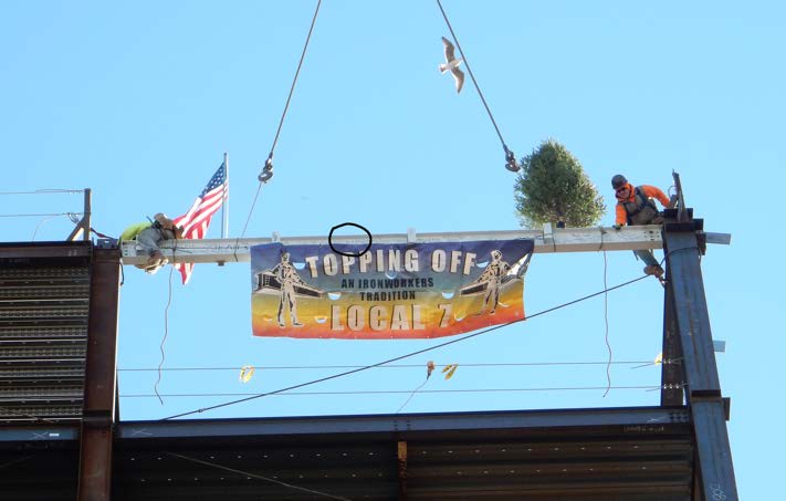 |
| Photo credit: Tom Dahill |
| One Canal Street, Boston Setting the Final Beam in Place |
We were offered pens to write on the beam: Tom wrote both our names and MCA. One of the “Hard Hats” yelled “Are you sure it’s gonna fit?” there was a chortle rippling through the crowd when another “Hard Hat” hollered “We had a dry run – it fits”. Lunch was offered after the event – Trinity Financial does a first class job.
While the building at One Canal Street is making progress, so is Tom Dahill on his painting “The Canal that Bisected Boston” which will go inside the front pavilion (area 2C). Tom is almost finished and recently confessed that he had spent more time on this project than any painting he had ever done. Of course it is only 20 feet tall and 7 feet wide – not your usual “over the sofa “ picture: and it must be historically accurate. Under the painting is a long (17-1/2 feet wide by 42 inches high) rectangular bronze plaque which will display the Hoxie Map, Gallatin’ s quote, and a few paragraphs of canal history. This too is nearing completion.
If all continues to go well, the Grand Opening of One Canal Street and Celebration may be as early as December 2015! You are invited!
A few months ago the Middlesex Canal Museum was approached by Harrie Slootbeek, Collections and Exhibit Manager of the U.S. Constitution Museum in the Charlestown Naval Yard. “Old Iron Sides” is due for a multi-million dollar restoration. She is to be placed in Dry Dock #1 designed by Loammi Baldwin Jr. in 1827. In preparing for construction of the dry dock, over 3000 pilings were rafted down the canal and used to stabilize the ground beneath it. Two such dry docks were constructed – the other being in Norfolk, Virginia. (See Howard Winkler’s excellent review in Towpath Topics for January and September 2012 at http://middlesexcanal.org/towpath/).
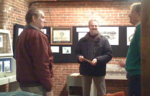
L-R: John Baldwin, descendant of Loammi; Harrie Slootbeek,
USS Constitution Museum; and J.J. Breen, MCA President
On display in the Middlesex Canal Museum, along with a model of the dry dock, was a miniature replica of the caisson, aka the gate, used to seal the open end of the dry dock. Both the dry dock and caisson models are owned by the Baldwin family and have been on indefinite loan to us; but now the Constitution Museum will borrow them, to become part of their exhibits. Prior to the dry dock design, ships were beached and, somewhat precariously, rolled from one side and then the other when repairs were needed. Dry docks, however, allowed the ship to maneuver into a rectangular box at high tide and be stabilized fully upright; then the caisson was used to close and seal the dry dock so that the water could be pumped out, leaving a dry field in which to work. It was a great improvement.
Due to our unusual weather and ice conditions, the dry docking of “Old Iron Sides” has been rescheduled, to be brought out of the water on May 19, 2015, for 2½ years of repair. A new caisson has been built and recently arrived (see https://vimeo.com/121287438 for a video of the arrival). This month there are 70 ship models on display in the U.S. Constitution Museum and other festivities are being planned. An exhibit planned around the Baldwin miniature is being made at this time. Meanwhile we will have a photo exhibit of the dry dock at our Museum.
The U.S Constitution Museum has on average 300,000 visitors annually. That’s about 300 times our annual rate. Hopefully they will come north to visit us!
TITLE TRACK OF A BROKEN RECORD
by Marlies Henderson
Playing vinyl records repeatedly can render a song into a grey area on the disk, especially the title track. This being a canal periodical, and not one about gramophones and music, I’ll shift the topic to a parcel of land sold for a song (‘one Dollar’) in 1925 to the Billerica Historical Society (BHS). The title was all but lost and 2014 assessor’s maps - both in Wilmington and Billerica – failed to show the Society’s interest of ownership.
The parcel straddles the banks of the Shawsheen, right where the river slices between neighboring towns. What was formerly bound by a wooden trough to carry a canal across is today united less tangibly by what John F. Sawyer, Executor of the Will of Erastus A. Bartlett, granted to the BHS. The date of conveyance is November 1925, but a few months later, May 1926, Warren Manning typed a note to Dr. Stearns:
“Answering your letter of April 15th regarding the land conveyed by Mr. Sawyer to the Billerica Historical Society at the Old Shawsheen Acquaduct [sic].
I am giving instruction to have the prints of the Old Canal surveys that I have brought together for me to look over to see if I can identify the lines of the Theophilus Manning land on this plan. If I cannot do this then I will have some sketch made at the registry of deeds in Cambridge and in Lowell.
What we need is a boundary indicated on the plan of August 6, 1925, 1469-2, that I prepared. As soon as this is done I will get in touch with you again.”
The Warren H. Manning client list associates project # 1469 with the BHS and the year 1925, and in his 1937 memoirs Manning purposefully writes that
“...a reservation was given to the Historical Society that included the Middlesex Canal Viaduct, over the Shawsheen river, as a memorial to William Manning of East Chelmsford,”
but other than that, I could not locate evidence of what specifically troubled Dr. Stearns. I must deduce he was concerned the recording of the conveyance needed attention.
The scribes of yore dutifully reproduced records in their personal longhand, first with quill, then by fountain pen, a finer nib. Today microfilm scans are available through fiberglass fed internet - if we have the patience to maneuver the electronic database. Deciphering the archaic tongue, registered in calligraphy or later hammered away per typewriter. Venturing on a title search is like time travel; a virtual track into the offices of registries. Grantors and grantees, real estate transactions, recorded, signed and sealed. Each record mentions the previous transfer of ownership, the ‘title reference’ and thus a chain materializes.
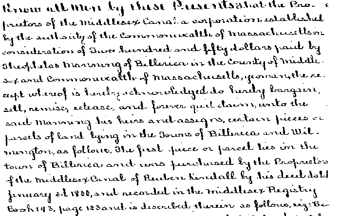
A deed dating back to 1860 brings an ancestor of Warren Manning into the picture:
”Know all men by these present that the Proprietors of the Middlesex Canal, a corporation established by the authority of the Commonwealth of Massachusetts in consideration of Two hundred and fifty dollars paid by Theophilus Manning of Billerica in the County of Middlesex and Commonwealth of Massachusetts, yeoman the receipt whereof is hereby acknowledged do hereby bargain, sell, remise, release and forever quit claim, unto the said Manning his heirs and assigns, certain pieces of land lying in the towns of Billerica and Wilmington as follows…”
And Book 23 page 206 goes on to spell the names of the owners who sold their land to the Middlesex Canal in 1800, and describes parcels mentioning stakes, clumps of birch trees, stone walls, counting
“...seven and three quarters rods to a large fast rock in the westerly stone pier which supports part of the Canal aqueduct over Shawshine [sic] river...”
Since Theophilus Manning owned it, this land near the aqueduct is alternately described as ‘Estate of Erastus A. Bartlett’, or ‘Hopkinson Land’, ‘Land in Billerica and Wilmington’, ‘Salem Road Aqueduct Land’, and even mispronounced as ‘Hopkiln’, with lettered subdivisions or names like ‘Lincoln Park’ and ‘Jackson Heights’. It helps to know that
“the interest of said Erastus A. Bartlett and Charlotte A. Bartlett ... is derived as sole devisees under the will of William Manning, late of said Chelmsford, deceased ... being a son of Theophilus Manning ...
A complex and confounding genealogy follows.
Within a month, two 1914 deeds appear to describe the same transfer (Bartlett to Hopkinson) in differing detail. The cursive reads:
“a strip of land in The Town of Billerica ... including the bed and towpaths of said Middlesex Canal”... it then refers back to the 1860 book 23, page 206 for “a more particular description by metes and bounds of the premises hereinbefore described”.
And here it comes:
“Excepting, however out of the premises hereinbefore described, for ourselves, our heirs and assigns, so much of said premises as lie easterly or southeasterly of a line drawn parallel with and twenty feet distant westerly from the outer face of the central portion or section of the most westerly stone pier or abutment of the old acqueduct [sic] which formerly carried said Middlesex Canal across the Shawsheen River. Said line so determined to be continued in a southerly direction until it strikes the Salem Road, so called, and in a northerly direction until it strikes the land of the adjoining owner on the north so that said line shall form the easterly or southeasterly boundary of the premises herein conveyed; it being the intent of all the grantors herein to convey to said grantee all of the premises which said Theophilus Manning acquired from the Proprietors of said Middlesex Canal up to said line and retaining also the bed of said Shawsheen River and so much of the land conveyed by the Proprietors of said canal to said Manning as lies in the Town of Wilmington on the easterly side of the Shawsheen River. Said premises are conveyed subject to the rights of the public in any highway or public way, passing through or over the same...”
Confusing in its detail but describing at length the aqueduct and parcels West and East of the Shawsheen “excepted” from the surrounding real estate, subject to public access, the wording more or less reappears in successive deeds - as it does in the conveyance of land to the BHS.
Reading the deeds, the wording of the excepted lot - the “twenty feet”, the “said line” ring out like a broken record, while proving that the recording has no break in the title chain; rather, there seems to be a double chain.
Having a Registry of Deeds in Cambridge and in Lowell may have contributed to confusion: Hopkinson transfers the land in 1914 to Pheeney. When Executer Sawyer managed the Bartlett Estate in 1923 he recorded a transfer from Bartlett to Suburban Land Co. and one from Suburban Land Co. to Pheeney, and a plan named ‘Estate of Erastus A. Bartlett’. Sawyer’s conveyance to the BHS was recorded in 1925, only to be recorded again in 1963, when subdivisions were all the rage and deeds were transferred like a relay race between team members as if aiming to lose language, shake off transparency or trigger clerical errors: A 1978 sewer easement doesn’t show the BHS lot, and mentions damages paid to Mary Burns. At this time Margaret Ingraham was involved when stairs were built on the BHS lot while a sewer was put in. She secured access to the lot, and to this day BHS maintains it on a regular basis. A 1988 plan incorrectly records the twenty feet from the middle of the river instead of from the westerly abutment, but the property deed still repeats: “...in a straight line drawn parallel with and twenty (20) feet distant Northwesterly from the outer face of the central portion or section of the most westerly stone pier or abutment of said old aqueduct ...”
Driving by on Rte. 129 at 30 miles an hour one can be clueless of the plethora of stories contained in this small area: The Old Joy Line trolley service, once diving into the Shawsheen, as if to seek refreshment, like so many swimmers on a sweltering day. Or the nearby speakeasy, built in the dry canal bed with a raised dance floor. Naturally, the prohibition era left few records of the establishment or its patrons.
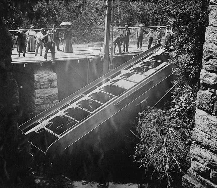 |
| Courtesy of Billerica Historical Society |
| Trolley Accident, by the Shawsheen Aqueduct |
Many tales are waiting to be told, but the title search is done. Clouds have lifted; there is no break in the chain of title. Recording the BHS lots on Billerica and Wilmington assessor’s maps is in the works, thanks to many historians, assessors and directors who helped me assemble the pieces of this story. I wish to acknowledge the time and attention given by Alec Ingraham, Andy Bowen, Bruce Richardson, J. Jeremiah Breen, Kathy Godfrey, Len Harmon, Maria Seminatore, Richard Howe, Richard Scanlon, Robert Kinsman, and Thomas Raphael. My apologies go out to those I inadvertently forgot to mention while trying to meet the deadline for submitting this story to the Towpath Topics newsletter.
PASSING THE BATON!
by Bill Gerber
This will be my last issue as editor of Towpath Topics. It was the Fall of 2007 when I turned out my first issue. I’ve learned a lot about the canal since then and hope that I’ve given at least as good as I’ve received.
I’d like to extend many thanks to all of the members and friends who contributed articles, photographs and other graphics to share with readers over the years. Many issues would have been quite ‘slim’ without your help.
Debra Fox and Alec Ingraham, both of Billerica, will assume the responsibilities for publishing future issues, beginning with the Fall issue. You can reach them at: debfox2015@middlesexcanal.org (Debra Fox) and alec2015@middlesexcanal.org (Alec Ingraham) which will forward to their personal email.
Robert Winters will still do the final layout, and have each issue printed and mailed out. He will also email copies to the few members who receive them in that form and, as you’ve likely noted, will add each issue to the growing archive of back issues at http://middlesexcanal.org/towpath. Robert really has made that into a worthwhile resource for anyone who wants to learn about the canal.
When I started I had a fairly good ‘pool’ of materials from the research I had done on the Canals of the Merrimack and Sullivan’s Towboats over the preceding several decades. By now, however, that ‘pool’ is pretty well depleted and I need to go back into the research mode. If successful, perhaps I can contribute additional articles from time to time.
There really are many things I still don’t know about the ‘old ditch’, and things I question, and thus there should be plenty of opportunities for additional research. In the interest of recruiting researchers to support the incoming editors, following are some of my unknowns and doubts:
Richard Frothingham had the unenviable task of running the canal during its last years of useful life, and overseeing its closure, property sales and eventual abandonment. This story has never been told very well. However, it might not be too difficult to do, many of Frothingham’s papers are archived at the Massachusetts Historical Society. That would be a good place to start.
Some years ago, someone produced a pamphlet describing the boats and rafts that operated on the M’sex Canal. It was a respectable effort, but nothing comparable was ever written for inclusion in TT. We really do need a good comprehensible article, to add to the TT knowledge base, that describes the freight boats, the Packets, the work boats, etc., and certainly the rafts of timber, many thousands of which must have been taken down the canal.
Coverage of Caleb Eddy and his administration has always been seriously deficient. Eddy was the “CEO” of the Middlesex Canal from 1825 to 1845, longer than any other. Many of the textile mills of Lowell, Nashua and Manchester began production about the time his tenure began and, for the first decade of it, these brought new business to the canal. With the new revenue, Eddy was able to rebuild much of the canal to accommodate the increased traffic and to lower maintenance costs. (E.g., Tom Raphael described rebuilding the Symmes River Aqueduct in TT 9/2011.) The coming of the railroads, to Lowell in 1835, to Nashua in 1838 and finally to Manchester in 1842, increasingly encroached on canal traffic and its corresponding revenues. By 1843, canal traffic had fallen so low that Eddy proposed repurposing the canal to carry Concord River water to Boston. We have a general knowledge of the progression of these events, but almost no in-depth examination of them. These should offer fertile ground for broad and sustained research. Regrettably, I have no idea where Eddy’s papers might be found, or if they even exist.
There are three “Toll Houses”, that I am aware of, that once served the business functions of the canal company. Located in Chelmsford, Woburn and Winchester, these are listed in the National Register of Historic Places; and I’d be willing to bet that others once existed in other canal-side communities. The toll house on Chelmsford Common, still pretty much in its original configuration, once stood at the top of the Merrimack flight of Locks in Middlesex Village. It carries a date of 1832 and is believed to be the oldest surviving toll house in the USA. I don’t know the dates of the others, but I expect that they were built around the same time. The “mystery” that surrounds these toll houses is that they do not seem to have replaced any prior toll houses; and so they seem to signify that a change occurred in the way the canal company conducted its business. What changed? How did the company operate prior to 1832; and how did it do so after that time? My guess is that articles and advertisements that tell this tale just might be found at the American Antiquarian Society in Worcester.
In his book “The Middlesex Canal”, Christopher Roberts tells us that the canal lost money for its investors, that the assessments added up to (I think it was) $740 per share of stock, whereas the return on them was only $590. But is this the whole story? E.g., the Middlesex Canal Company was a one-third participant in the construction of the Canal Bridge (aka Cragie’s Bridge) across the Charles River, which opened in 1809 between Leverett Circle and Lechmere Point. This was a toll bridge and the Company would have shared in the tolls. So, did the $740 per share also cover the MCC’s contribution to bridge construction? What was the return to investors from bridge tolls, and later from the sale of the bridge in 1846?
Similarly, the MCC was a major investor in the canals of the Merrimack; to the ‘tune’ of about $400K. The company’s interests were sold off in the mid-1830s. What was the sale price and was that money not distributed among the shareholders? Roberts makes no mention of either of these. It seems to me that the whole question of the Canal’s profitability should be reexamined.
There is a record of an elephant being brought up the Middlesex Canal to Medford (on the towpath, I hope!). Martha Mayo, Director and archivist at the Mogan Center in Lowell, once told me that, on market day, some of the local farmers ‘boated’ their produce to market in Lowell. At Mount Union, along the Pennsylvania Mail Line Canal, local residents looked forward to the weekly arrival of the ‘Grocery Boat’. During a canal trip to England, many years ago, several participants attended a performance by the Mikron Theater, a theater company that traveled around the UK canal system by ‘narrow boat’, giving performances at canal-side towns and villages. All of this raises the question - what other commodities and activities traveled on the Middlesex Canal; and what’s the story behind them?
The Livestock Conservancy seeks to preserve breeds that have fallen out of favor. On their behalf, the most recent issue of American Canals asks if anyone knows what breeds of tow animals were used on the nation’s towpath canals. I haven’t a clue; do any of you?
I don’t have much information about any of the tow animals. My very limited perception is: that Rafts, and “bands” of rafts, were usually towed by Oxen, probably a pair and probably harnessed to allow travel in tandem as well as side-by-side. Luggage Boats were probably towed by a horse, possibly two, and if the latter, also harnessed in tandem. And I think that, barring unforeseen circumstances, the tow horse or horses traveled all the way through between Chelmsford and Charlestown. Packets were typically towed by two horses, probably also harnessed in tandem, but since they traveled at a faster pace, these were changed out at Tay’s tavern, about half-way along the length of the canal. What little information is available suggests that horses and oxen were used on the M’sex, but not mules. But all of the above is from “reading between the lines; can any of it be documented? And while trying, can any of the breeds be identified?
Bottom line to all of this is that I hope that at least a few MCA members will take on a task to research some aspect of the canal, and from that research will provide our new editors with fresh material to share among our membership and the public. Will you help?
Nameplate - Excerpt from a watercolor painted by Jabez Ward Barton, ca. 1825, entitled “View from William Rogers House”. Shown, looking west, may be the packet boat George Washington being towed across the Concord River from the Floating Towpath at North Billerica.
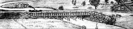
Back Page - Excerpt from an August,1818, drawing (artist unknown) of the Steam Towboat Merrimack crossing the original (pre-1829) Medford Aqueduct, probably on its way to service on the Merrimack River.
Estate Planning - To those of you who are making your final arrangements, please remember the Middlesex Canal Association. Your help is vital to our future. Thank you for considering us.
Museum & Reardon Room Rental - The facility is available at very reasonable rates for private affairs, and for non-profit organizations’ meetings. The conference room holds up to 60 people and includes access to a kitchen and rest rooms. For details and additional information please contact the museum at 978-670-2740.
Web Site - As you may have noted in the nameplate, www.middlesexcanal.org is the URL for the Middlesex Canal Association’s web site. Our webmaster, Robert Winters, keeps the site up to date, thus events and sometimes articles and other information will sometimes appear there before we can get it to you through Towpath Topics. Please do check the site from time to time for new entries.
Back Issues - Fifty years of back issues of Towpath Topics, together with an index to the content of all issues, are also available from our web site at http://middlesexcanal.org/towpath. These are an excellent resource for anyone who wishes to learn more about the canal and should be particularly useful for historic researchers.
Canal Boat Rides - The American Canal Society maintains an annotated list of more than two-dozen canal boat ride concessions that operate at various places in the eastern USA and parts of Canada. The list can be found at www.americancanals.org/Canal_Boats/Canal_Boats.htm. Go take a boat ride!
This issue of Towpath Topics was edited by Bill Gerber and published by Robert Winters.
Debra Fox and Alec Ingraham will take over as co-editors for future issues, beginning with the Fall 2015 issue. They can be reached at: debfox2015@middlesexcanal.org (Debra Fox) and alec2015@middlesexcanal.org (Alec Ingraham).
Corrections, contributions, and ideas for future issues are always welcome.
Towpath Topics is edited and published by Bill Gerber and Robert Winters.
Corrections, contributions, and ideas for future issues are always welcome.