
Middlesex Canal Association P.O. Box 333 Billerica, Massachusetts 01821
www.middlesexcanal.org
| Volume 55 No. 1 | September 2016 |
14th Bicycle Tour North, 9:00am, Saturday, September 24, 2016
Special Event
Rededication of the High Street Canal Marker
1:00pm, Wednesday, October 5, 2016
Fall Walk, 1:30pm, Sunday, October 16, 2016
Winchester-Medford
Special Event
J. J. Breen: The Middlesex Canal in Winchester
“4,000 Tons of Granite at Sandy Beach”
7:00pm, Tuesday, October 18, 2016
Winchester Historical Society
Fall Meeting, 1:00pm, Sunday, October 30, 2016
Bill Gerber “Canal Side Landings”
Winter Meeting, 1:00pm, Sunday, February 12, 2017
TBA
TABLE OF CONTENTS
Events and Directions to MCA Museum and Visitor Center
Luther A. Roby, Boatman by Bill Gerber based on materials supplied by Sherm Sewell
The Canal that Bisected Boston by Betty Bigwood
The Middlesex Canal Commission Annual Meeting Progress Report
Part III of The North Billerica Mill Village in 1850 by Alec Ingraham
Catherine Baldwin by Debra Fox
Editors’ Note
Welcome to the second year of Towpath Topics under its “new” editorship. The past year has gone by very quickly, and we hope the issues have been as enjoyable for you to read as we have enjoyed putting them together for you.
Please mark your calendars for the upcoming events with the MCA this fall. As a special treat for those of you unable to attend last summer’s dedication to Tom Dahill’s mural at One Canal Street, we have printed Betty Bigwood’s speech, with photos, and a description of the site. Check it out for yourselves the next time you are at TD Bank North Garden.
This issue of Towpath Topics should have something for everyone. Two continuing articles are concluding, one on Loammi Baldwin, Jr. and the second on the North Billerica Mill Village. There is an informative contribution from former editor, Bill Gerber, on Luther Roby, boatman on the Merrimack River and Middlesex Canal. Also, there are event entries on poetry and women to round out this month’s issue.
As always, comments are welcome. —— Deb, Alec, and Robert
Events
MCA Bicycle Tour
The 14th bicycle tour of the Middlesex Canal will be led by Dick Bauer and take place on Saturday, September 24, 2016. Riders should assemble at 9:00 A.M. at the Middlesex Canal Plaque at the entrance to the Sullivan Square T Station (1 Cambridge Street, Charlestown 02129). The 38-mile tour will head north following the route of the Middlesex Canal and will end in Lowell in time to meet the 5 o’clock train to Boston. For additional details and a tour schedule please Google: Canal Ride Cue Sheet. Participants are welcome to join the tour in progress.
MCA/BHC Special Event
This event is tentatively scheduled for 1:00 P.M. on October 5, 2016, just prior to the MCA Board meeting. In the year 2015, the Billerica Historical Commission obtained a community grant from EMD Serono to landscape the area around the Middlesex Canal Marker on High Street in North Billerica. The grant funds were not sufficient to complete the project, but the MCA contributed the balance necessary. Work at the site, which began on September 1, 2016, will be completed in advance of the October 5th ceremony providing an opportune time to recognize the achievement. For more detail please see the Middlesex Canal website.
MCA Fall Walk
On Sunday, October 16, 2016 members and guests of the MCA are invited to a pleasant walk and talk on the remnants of the Middlesex Canal. Those planning to participate in the walk are encouraged to meet at 1:30 P.M. in the Sandy Beach parking lot, 4 Mystic Parkway, Winchester, MA 01890. Sandy Beach is a ten minutes’ walk from the Wedgemere train station. The walk will follow the route of the towpath south for a round trip of four miles. The turnaround at Sagamore John Memorial is near the West Medford train station. This is a joint walk sponsored by the Appalachian Mountain Club and the Middlesex Canal Association. More information is available on the Web at www.middlesexcanal.org.
If you can say Welcome to the Museum, we need you. The Middlesex Canal Association needs volunteers to greet visitors to its free museum, open 12 – 4, Saturday and Sunday, at the Billerica Falls of the Concord River, 71 Faulkner Street, North Billerica, MA 01862. Email: jj@middlesexcanal.org.
MCA Special Event
On Tuesday, October 18, 2016, J. J. Breen, President of the Middlesex Canal Association, will address the Winchester Historical Society, 15 High Street, Winchester, MA 01890.
His talk entitled “The Middlesex Canal in Winchester: 4,000 Tons of Granite at Sandy Beach” should serve to enlighten those in attendance on this fascinating part of Canal history. For background information please read Tom Raphael’s article, pages 13-17, in Towpath Topics, http://middlesexcanal.org/Towpath Topics-Sept2011color.pdf. Refreshments will be served at 7:00 P.M. in advance of the presentation at 7:30 P.M.
MCA Fall Meeting
At 1:00 P.M. on October 30, 2016, the Middlesex Canal Association will hold a public meeting at the Middlesex Canal Museum and Visitors’ Center, 71 Faulkner Street, North Billerica, MA. The featured speaker will be Bill Gerber. The title of Bill’s talk is Canal Side Landings.
In the first half of the 19th century a 120-mile system of canals and navigable waterways provided “heavy lifting” transportation services throughout the Merrimack Valley and the area north of Boston. Interspersed throughout much of the system were more than three dozen “Landings” which provided shipping and receiving services for those who had goods to transport.
Bill notes that this is something of a status report on a continuing, very long term effort, not a final report.
The Middlesex Canal Museum and Visitors’ Center – The Middlesex Canal Museum and Visitors’ Center is open every Saturday and Sunday from 12 until to 4:00 P.M., except holidays.
MCA Board of Directors’ Meeting – The Board meets at the Canal Museum from 3:30pm to 5:30pm on the first Wednesday of each month with the exception of July and August. Members are welcome and encouraged to attend.
Directions to Middlesex Canal Museum and Visitors’ Center
By Car: From Rte. 128/95
Take Route 3 toward Nashua, to Exit 28 “Treble Cove Road, North Billerica, Carlisle”. At the end of the ramp, turn left onto Treble Cove Road toward North Billerica. At about ¾ mile, bear left at the fork. After another ¾ mile, at the traffic light, cross straight over Route 3A (Boston Road). Go about ¼ mile to a 3 way-fork; take the middle road (Talbot Avenue) which will put St Andrew’s Church on your left. Go ¼ mile and bear right onto Old Elm Street. Go about ¼ mile to the falls, where Old Elm Street becomes Faulkner Street; the Museum is on your left and you can park across the street on your right, just beyond the falls.
From I-495
Take Exit 37, North Billerica, south roughly 2 plus miles to the stop sign at Mt. Pleasant Street, turn right, then bear right at the Y, go 700’ and turn left into the parking lot. The Museum is across the street (Faulkner Street).
By Train:
The Lowell Commuter line runs between Lowell and Boston’s North Station. From the station side of the tracks at North Billerica, the Museum is a 3-minute walk down Station Street and Faulkner Street on the right side.
 President’s Message
J. Jeremiah Breen, President
jj@middlesexcanal.org
The guard lock in the Talbot millyard is going to be filled and buried under concrete because the existing concrete slab bridge is broken. In 2015, a dump truck smashed the slab. The good news is that the restoration of the truck turnaround in the millyard will be done with a care for the only one of the twenty locks of the Middlesex Canal still visible.
From the 1829 survey by George Baldwin, we know the lock was 89.8' long, heel post to heel post. (The average length of a lock in a staircase was 84'.) The bottom width was 10', sized for the 9½' maximum allowable width of a canal boat, with the walls sloped back, battered, say ½ foot, away from the water with an 11.1" width of the lock, measured ~ 4' below the level of the heel post collar. The stone courses between the collar and 4' below were pushed inward on both sides of the lock because of freeze-thaw cycles.1 The west guard lock of the twenty locks of the canal has lasted because it was used as a head race for two turbines in the Talbot Mill, generating electricity at 550 volts AC.
The elevation on the miter sill on the high side, the river side, is 103.81' (NAVD88)2. On the low side, it’s the same elevation.3 When Loammi Baldwin laid out the lock in c1794, presumably the 24' 6" lift from the Merrimack River to the Concord River measured by the consulting engineer,4 was done at the 3-step staircase at the Merrimack. The level of the Concord River would be at the level of the dam as its flow would be through the mill canals with little of the waterpower wasted over the flashboards. The guard lock would be needed during Concord flood stages. Later, when rock was encountered in the “Deep Cut” on the east side of the Concord, Baldwin chose to raise the river level using the flash boards on the dam, rather than blast the rock. The elevation of the stone miter sill of the east guard lock is 104.58' (NAVD88), 9¼" higher than on the west.
The sills at 103.81' are likely still there, buried. Another miter sill now in the lock is at el. 107.7' (NAVD88).5 This latter miter sill was likely for a guard gate when the canal was used as a mill race.
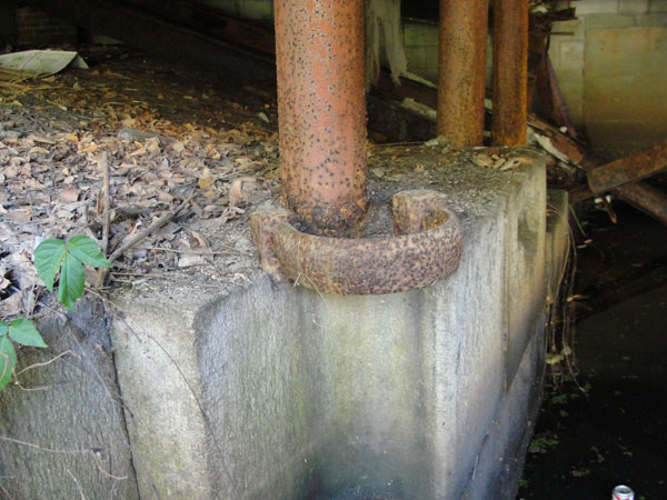 Hollow quoin and heel post collar, 11" diameter. |
Prior to 2016, the west guard lock was buried to approx. 10' west of the upper gate hollow quoins. A corroded 12" gate valve was east of the retaining of the buried lock, with a 12" pipe west through the retaining wall, formerly used to supply river water to the fire sprinklers. A screen was mounted in a retaining wall between the inlet of the valve and the upper gate. In the as-built repair of the concrete pavement above the lock, a retaining wall was built in the screen opening. New pavement was placed to < 3' west of the heel post collar of the upper miter gate. With removal of the old slab and its shortened replacement the view of the hollow quoins, heel post collars,6 and gate pockets of the miter gate are unobstructed.7
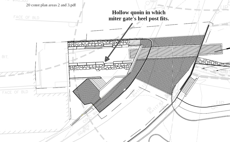
The detail in the lower image below is from the 25% plan for the future Middlesex Canal Park at the summit pond. The filling of the lock to just west of the hollow quoin does not prevent the development of area 2.
Notes:
1
Revision in December 2016. J. Breen
2 “I recollect the top of the stone sill on the east side was 4 ft. 2¾ inches below the top of the flash board. The top of the wood sill was 5 ft. The difference is 9¼ inches.” Warren Nixon, surveyor, testifying October 14, 1859, describing measurements done that month, www.tinyurl.com/Jan1860report.
3 George Baldwin in 1830 measured the elevation on the lower gate sill [of the west side guard lock] as 108.48', or 103.81' (NAVD88). The high sill at the 3-lock Merrimack staircase was 102.89', and the low was 78.58', differnce, 24.31'. The gate sill of the timber lock had el. 104.22'. Cf., east guard lock stone sill, 104.58'. See https://archive.org/details/Middlesex_Canal_Plan_and_Profile.
4 William Weston, August 2, 1794, Appendix 2, Mary Stetson Clarke, The Old Middlesex Canal, p. 153.
5 Measured by J. Breen, transit, and Russ Silva, rod, in 2014.
6 The name heel post might be based on the manner in which the weight of a miter gate leaf is borne by the gudgeon at the apex of a right angle, like a heel at the apex of leg and foot. Another name is quoin post.
7 Revision in December 2016. J. Breen
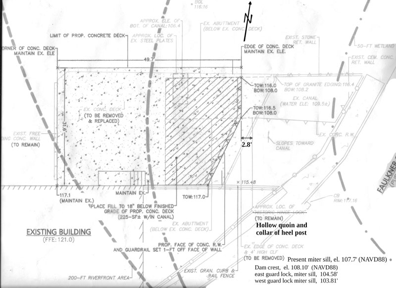
Part of June 28, 2016 preliminary drawing, "Deck Replacement Plan",
for Pinnacle Construction Co. with changes by J. Breen. Not as-built.
J. J. Breen, MCA President
Another Side of Loammi
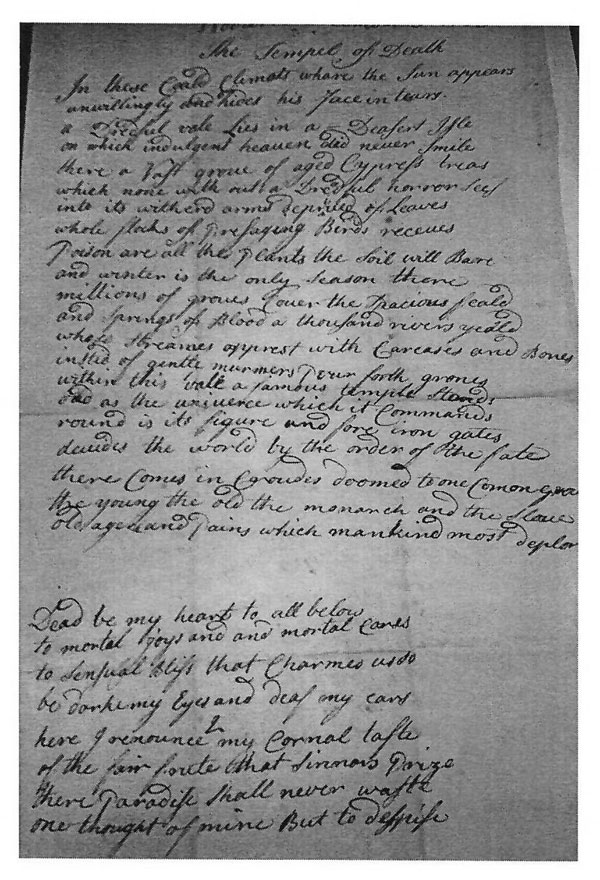
The following poem, The Tempel of Death was discovered folded up in Loammi’s desk by James Baldwin (direct descendant of Loammi) while archiving the numerous Baldwin Family artifacts. There was some thought that Loammi was ill when he penned the poem, but James provides us with his opinion and a suitable introduction.
“Unfortunately, while I do know he suffered a few serious illnesses I don’t know specific dates. I read this poem as more of a religious statement condemning sin and less of a personal expression of dark thoughts. But I am a scientist not a poet so take my interpretation with a grain of salt. :-)
He would have been around 21, I believe, and in the midst of his early scholarship, so it was probably an expression of that mindful state that young scholars often inhabit. One thing that is clear from his letters and that of his children is that they were all deeply intellectually curious folks.
I have far more of Loammi Jr’s writings, so I have a better picture of his children than I do of him, but in Loammi’s obituary and writings from his contemporaries he was known for his good humor and joie de vivre.”
Editor’s Note: James was kind enough to decipher the poem and present it as accurately as possible preserving the original spellings. The question marks indicate uncertainty as to the exact word in the original manuscript.
Woburn, December 15th 1765 In these cold climats whare the Sun appears unwillingly and hides his face in tears. a Dreadful vale lies in a Deasert Isle on which indulgent heaven did never smile there a vast grove of aged Cypress treas which none with out a Dreadful horror sees into its witherd arms deprived of leaves whole flocks of poresaging(?) Birds recueues Poison are all the plants the soil will Bare and winter is the only season there millions of groves cover the spacious Feald and Springs of Blood a thousand rivers yeald whose Heavaes apprest with Carcases and Bones instid of gentle murmers pour forth grones within this vale a famous temple stands asnd as the universe which it communes round is its figure and fore iron gates decides the world by the order of the fates there comes in caroudes doomed to one comon grave the young the old the monarch and the slave old age and pains which mankind must deplor
Dead be my heart to all below to mortal joys and and mortal cares to sensual bliss that charmes undo(?) be darkening eyes and deaf my ears here forenounce(?) my carnal taste of the fair foute that sinners prize there paradise shall never waste one thought of mine but to despite dcd L.B by Th. R |
 |
Luther A. Roby, Boatman
by Bill Gerber, based on materials provided by Sherm Sewell
About a year ago, I crossed paths with Mr. Sherman Roby Sewell of Nashua, NH. Mr. Sewell gave me a copy of a paper that his grandfather, William Roby Swart, had presented to the Nashua Rotary Club, telling of the life of his grandfather, Luther A. Roby, i.e., Mr. Sewell’s GG- grandfather.
Early in his adult life Luther Roby was a boatman on the Merrimack River and Middlesex Canal. Although the paper does focus on Mr. Roby’s life, it also provides considerable additional information about the old navigation waterways and how they were used.
Mr. Sewell’s paper is appended below. Some things to look for include:
There are additional points to check out, and a few to quibble with; e.g.:
The text of the Roby paper follows -
Luther A. Roby Businessman of Old Nashua
I have been asked to present a short sketch of the life of Mr. Luther A. Roby, his business pursuits and characteristics, and in writing this, I have been fortunate in being able to draw upon a paper which my father, Col. Swart, read sometime ago before the Nashua Rotary Club.
As you probably know, Mr. Roby was my grandfather on my mother’s side, she being the youngest of the three children, Clara R. Wheeler, Charles A. Roby, and Lizzie R. Swart. Probably some of the people here tonight remember Mr. Roby, and although I was fairly young at the time, I myself have many distinct recollections of my grandfather.
Mr. Roby was born on the Roby Farm about three miles below this city on October 24, 1814, and died at the ripe old age of eighty-seven, having like his Father and Grandfather always lived in this town. In his boyhood days he worked and lived upon the Roby Farm, and acquired his education in the little old school house under the hill called the Gilboa District. In his early manhood he became a boatman upon the Middlesex Canal, making regular trips from Nashua to Boston. The old waterway can easily be seen today from the car windows between Lowell and Woburn.
Just a word about the old canal! It was the first canal ever built in this country for the general transportation of merchandise and passengers, and was chartered in 1793 and completed in 1804 at a cost of $700,000. It ran from Charlestown to Lowell, a distance of 31 miles and was 24 feet wide and 4 feet deep, and was largely fed by the waters of the Concord River. A small packet boat named the “The Governor Sullivan” plied regularly between Lowell and Boston and took about one day to make the trip. The canal entered the Merrimack just above the Pawtucket Dam (sic) and near the Lowell Street Railway Car Barns. The route was extended in 1826 to Nashua, the Nashua Manufacturing Company having obtained a charter in 1824 for the purpose of building a canal with locks and dams to connect the Merrimack with the Nashua River. It entered the Merrimack near the foot of Lock Street and the westerly terminal of the route was at a dock under what is now the old Nashua Telegraph Publishing Company’s building on Main Street. This entire waterway was discontinued about 1851, soon after the advent of the steam railways into Nashua.
In order to present a picture of the canal system from Boston to Nashua as it was in Mr. Roby’s time, I will quote from an article in the “Granite Monthly” of 1886, written by General George Stark. “During the entire season of open river, from the time that the spring break-up of winter ice permitted navigation to commence, until the frosts of fall again closed in, this eighty-five miles of water was thronged with boats, taking the products of the country to a market at the New England metropolis, and returning loaded with salt, lime, cement, plaster, hardware, leather, liquors, iron, glass, grindstones, cordage, oils and all the infinite variety of merchandise required by country merchants, formerly classed under the general terms of “dry and West India goods.” The original bills of lading, many of which are now in the writer’s possession, also show that they brought upon from Boston for consumption in the country, flour, corn, butter, and cheese, which plainly indicates that the people of the Merrimack River Valley gave more attention in those days to lumbering and river navigation than to agriculture.”
“These boats, of which there are probably none now in existence, were peculiarly constructed to answer the requirements of the river and canal navigation, and their mode of propulsion was as peculiar as their model. They were about seventy-five feet long and nine feet wide in the middle; a little narrower at the ends, flat bottomed across their full width, but the bottom sloped or rounded up from near the mid-length of the boat, both towards stem and stern. so that while the sides were level on top, and about three feet deep at mid-length, they were only a foot or less in depth at either end. A load of about twenty tons would make the boat draw two feet or more, near the middle, while the bottom would be out of water at each end. When the river was low in mid-summer, only about half a full load could be carried to Concord.”
“The boats were built of two-inch pine plank, spiked on small oak cross- joists and side-knees, and had heavy oak horizontal timbers at either end. The sides were vertical and without cross thwarts, except what was called the mast-board; a thick oak plank, securely fastened across the top, from side to side, a little forward of the centre of the boat. The seams between planks were calked with oakum and pitched. The mast was a spar about twenty-five feet long and six inches in its largest diameter. A foothold or step was fixed in the bottom of the boat under the cross-plank to receive it, and it was further steadied by the cross-plank, which was slotted to admit it when set up, and had a wedge and staple arrangement to hold it in place. A cross yard, with a square sail attached which could be hoisted or lowered at pleasure by a rope working over a single block in the top of the mast, completed the sailing outfit. It was only used upon the river, the mast being struck and stowed in the boat when passing the larger canals. The rudder was a long steering oar, pivoted on the centre of the cross-frame of the stern, the blade, about eighteen inches wide and ten feet long, trailing in the water behind the boat, and the handle or tiller extending about the same distance over the boat, so as to afford a good leverage for guiding the unwieldy craft. Three large scull oars, about sixteen feet long with six- inch blades, and three setting poles, or pike poles as they were sometimes called, stout, straight, round poles, wrought out of tough and springy ash, about fifteen feet long, nearly two inches in diameter and shod at one end with a long iron point, competed the propelling outfit. The crew consisted of a skipper and two bowmen.”
“In going down the river between canals the usual mode of propulsion was by use of the scull-oars. The bowmen took position close to either side of the boat, facing the bow and about six feet from it, and each worked his oar against a thole-pin placed in the opposite gunwale, the oar handles crossing, so that they were necessarily worked simultaneously. The skipper also had his oar, which he worked in a similar manner when his attention was not wholly taken up in steering. When there was a fair wind the sail would be hoisted. The current also materially assisted on the downward trip, and sometimes the poles would be used.”
“On the return trip against the current, the setting poles were the chief reliance, sometimes aided by the sail. The cargo was so piled in the boat as to leave a narrow passage next to each gunwale from the bow to the mast-board. There was also a clear space of six to ten feet left at the bow, and enough at the stern to allow the tiller to be moved freely across the boat. To propel the boat by poling, a bowman stood on either side of the bow, with his face toward the stern, and thrusting the pike end of his pole down beside the boat in a slanting direction toward the stern until it struck the bottom of the river, he placed his shoulder against the top of the pole, and, with his feet firmly braced against the cross-timbers in the bottom of the boat, he exerted the strength of his body and legs to push the boat forward. As it moved, he stepped along the bottom of the boat still bracing his shoulder firmly against the pole until he had walked in this manner to the mast-board, or rather, until the movement of the boat brought the mast- board to him. He then turned round and walked to the bow, trailing his pole in the water, thrust it again to the bottom of the river, and repeated the pushing movement. The skipper also had his pole, but having very limited space to work in, and being obliged to mind the helm pretty closely in moving against the current, he could do comparatively little to aid the progress.”
“These modes of propulsion applied only to the river and the river canals. The boats were towed through the Middlesex Canal by horses. A trip from Concord to Boston and return usually took from seven to ten days.”
“Concord, Piscataquog, Litchfield, and Nashua each had its lines of boats, making in the aggregate quite a little fleet. The broad reaches of the river had also upon it, for three or four years subsequent to 1834, a fair-sized steamboat, plying passengers and freight between Nashua and Lowell.
She was commanded one season, by Capt. Jacob Vanderbilt of Staten Island, New York, brother to the late Commodore Vanderbilt.”
“In the early part of the season, while the water of the river was at its highest stages, it was also thronged with logs and lumber being taken down for market. The larger falls being impassable except by their canals, the logs and lumber had necessarily to be bound into rafts of such dimensions as would pass through the locks. And at the larger canals, such as the Amoskeag and Middlesex, the labor of locking down and towing these rafts -- called shots -- was very considerable and consumed much time. Between canals these shots were bound together into large rafts of eight or ten shots, called bands, and floated down with the current, generally at high water, avoiding the locks at the smaller canals by running the falls.”
“Many of these rafts continued down the river to Newburyport, passing the Pawtucket falls through a canal and locks constructed for navigation purposes about the same time as the other Merrimack River canals but by different parties, who subsequently (in 1821) sold out to the Lowell manufacturing companies. Newburyport rafts usually consisted of ship- timber, masts, lumber and wood; and, if starting from any place below Amoskeag Falls, could be made into larger shots than those destined to pass through the Middlesex Canal, because the Pawtucket canal locks were much larger.”
Venturing beyond the calling of a boatman upon the Canal, Mr. Roby next engaged in the lumber business with George McQuesten, forming a co- partnership under the firm name of Roby and McQuesten. Their business was located on the bank of the Nashua River near where Shedd’s coal yard now is, just below the City Station on Railroad Square. It was here they operated a water power sawmill. Mr. Roby was successful in his chosen line of business, but the firm finally sold out to Sargent and Cross, and Mr. Roby then engaged in the oak timber business. His yard, consisting of about 2-1/2 acres, was located where now stands the Boston and Maine Railroad freight sheds. This piece of land was sold by him to the Railroad Company in 1892. It may be of interest to know that on that particular piece of land far from tide water, hundreds of vessel frames were hewn from the sound New Hampshire oak, which by the way has always been conceded to be the very best ship timber produced in the world. This timber was hewn by hand to a pattern or form; each piece to fit in a certain part of the ship’s frame, and my father once remarked that it was almost unbelievable, the expertness with which those old fellows swung an adz, hardly the variation of a hair in their stroke. If golf had been as popular in those days as it is today and those old fellows had turned their attention to that pursuit, while it might have required a different kind of stroke, yet for accuracy I doubt if there are many golfers in this city who could compare with them.
After being cut to form, the timber was then shipped to Newburyport, East Boston or some other ship-building yard, and then used in the construction of some of the finest 4, 5 or 6 masted sailing vessels ever produced.
In this way Mr. Roby became largely interested in vessel property, and was at one time said to be the largest sailing vessel owner in New England, having an interest in over one hundred vessels.
I have in my possession a small booklet written by the wife of the captain of the Schooner Louise H. Randall, and in her description of the vessel she says: “The Louise H. Randall had every reason to be proud of her ancestral tree, as she was built from timber grown in the far-famed woods of New Hampshire, in the estate of Mr. Luther A. Roby of Nashua, who was one of the largest owners in the vessel. Her keel was laid in July, 1891, in the yard of John M. Brooks, in East Boston, on the blocks where the ship Great Republic was built. At the date of launching, April 28, 1892, the Louise H. Randall was the largest schooner ever built in Massachusetts. She was two hundred feet long, forty-two feet beam, and twenty-six foot depth of hold.
Her tonnage was 1,500, carrying capacity 2,700. She was fitted with an engine of twenty-five horse power for hoisting anchors and sails, and also for the discharge of cargo. After launching, she was towed to Fisk’s Wharf, where she was fitted with her spars and rigging.”
In addition to ship timber, Mr. Roby specialized in oak piling, and I have no doubt that most of the docks, wooden bridges and trestles about Boston, East Boston, South Boston and Charlestown are built upon the foundation furnished by him.
You may wonder where all this oak came from, but in those days, 50 to 75 years ago, oak was one of the predominate woods in our forest growth, and nearly every farm in the southern part of our state had more or less to sell. These farmers all knew Mr. Roby, and such was his reputation among them, that he was allowed to go into their timber tracts, select such trees as were suitable for ship timber or piling as he desired. His survey was always accepted, and his settlements always fair and just. He seldom entered into contracts but his word was always as good as his bond and was accepted as such by those who had business relations with him. I believe he never had a law suit, and he always shunned political office. A noble character and a true man -- a personality which we might all emulate to our own profit and for the benefit of mankind.
December 19, 1832.
Simon Spaulding and Luther A. Roby were the two men who fired a salute from a cannon on top of Bunker Hill Monument at its dedication, before the peak was put on. So said Spaulding - R. W. Farley’s scrap book.
The fathers of these two men fought in the Battle of Bunker Hill, fifty years before.
From Mrs Kimball Jan 13, ’36
above verified by Mrs Kimball
“THE CANAL THAT BISECTED BOSTON”
by Betty Bigwood
This Grand Opening of One Canal Street today marks the culmination of 15 years effort by the Middlesex Canal Association to have a historical interpretation of the Middlesex Canal in Boston. None of this would have been possible without the support of Dick Garver of the BRA who offered us site 2C at One Canal Street for our endeavor. We are grateful.
Albert Gallatin, Secretary of the Treasury called the Middlesex Canal “the greatest work of its kind”. The Middlesex Canal was a transportation canal which connected the Merrimack River at today’s Lowell with the Charles River at Charlestown. It was dug over a ten year period (1793-1803) 27.3 miles long using pick axes, shovels and horse drawn carts. Boston was growing and needed raw materials. The canal was later extended north to Concord, NH and south through Boston.
This southern extension is what we highlight today with the Dahill mural, “The Canal that Bisected Boston”.
While you are seated comfortably today, in 1630, when Boston was incorporated, you would be in the middle of a Mill Pond treading water. The tides of the mill pond provided energy for three grist and saw mills for 175 years. When it started to silt up, Boston Selectman and architect Charles Bulfinch drew a triangular grid over the area leaving unfilled a canal down the middle. This allowed canal boats to bring cargo through the Bulfinch triangle and Mill Creek directly into the Boston Harbor. Today we sit in this Bulfinch Triangle adjacent to the canal which ran parallel to today’s Canal Street.
By far the most abundant material brought down on the canal was wood. Thousands of trees felled in NH were bound into rafts 9ft by 70ft. Some were diverted by a branch canal to Medford where sea going ships were constructed, some were turned into pilings for building wharves and stabilizing the mud flats to accept soil, building construction, fuel and used in the first dry dock construction where “Old Iron Sides” is currently undergoing a three-year renovation. Granite quarried in Chelmsford was used to build the Bulfinch Building of the Mass General Hospital, Faneuil Hall, the Harrison Grey Otis House. Millions of bricks came down from Medford where they had natural deposits of clay. Tons of hay for horses came into Haymarket Square. Hops grown in Wilmington was brought to breweries in Boston and New York. Food grown on farms, including Baldwin Apples came down the canal. On the other hand, bales of cotton came into the Boston Harbor by ship and were transported up to linen mills in Waltham, Salem, Lowell. Sugar cane came up from the south and was brought to distilleries to make Medford Rum. Sugar, cinnamon, nutmeg came from the Caribbean. Upscale furniture and Chinese export ware were brought up the canal. This was just the beginning.
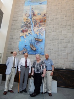 Tom Dahill, Tom Raphael,Betty Bigwood, Howard Winkler |
Artist Thomas Dahill has captured in his mural the excitement and business of the area. His extensive curriculum vitae is on the back of the brochure. Tom started on his mural in his studio in 2014 and took about 7 months to complete. The painting is 3 1/2 by 10 ft. high. It was photographically doubled in size. Last year Tom was on two ten foot ladders and scaffolding - painting away. This is even more remarkable when you realize that three weeks ago – June 22 –he celebrated his ninety first Birthday. Join me in applauding Thomas Dahill.
Editors’ Note: General Information about One Canal Street and the Dahill Mural
One Canal street now has “A Dahill”. It was hung by John Kirby et. al. of Boston Arts who supervised the transfer of Tom’s 3 and 1/2 ft wide by 10 ft long acrylic painting to a 6 panel photographic copy 7 ft by 20 ft high mural. Each panel weighs ~40 lbs. This picture taken by Tom shows the whole room. The colorful picture “ The Canal That Bisected Boston” adds a spark to the whole room. The battleship grey color surround takes a background to the mural. The stone was quarried in Chelmsford, both for the back drop and the four seats of building blocks upon which you can rest and enjoy the view. This idea came from the Shawsheen Aqueduct. The idea of using Chelmsford granite was an attempt to connect the Boston location to the Middlesex Canal site, the Shawsheen Aqueduct.
Murano glass globes in the ceiling provide evening light and the windows allow daylight to brighten the mural beautifully. There are two “bronze” panels below the mural which tell the story and show the Hoxie Map - done by Bob Shure of Skylight Studios in Woburn. Above the “Bronze” panels are a series of water fountains bubbling up. The Hoxie Map is etched in glass in multiple panels above the stairs, over the concierge desk and along the entire lobby wall. The manager wants to place books about the Canal on coffee tables in the lobby. This is truly a “CANAL ENTRANCE”.
Middlesex Canal Commission Annual Meeting Progress Report
On March 31, 2016, the Middlesex Canal Commission (MCC) annual meeting was held at the Middlesex Canal Museum and Visitors’ Center in North Billerica. The meeting was attended by representatives from the various towns and cities through which the canal passed on its 27 ½ mile route from Charlestown to the Merrimack River near the Pawtucket Falls.
In the 1980’s, the Commission established a five phase strategic plan to accomplish preservation of the canal and the canal’s rich history. In 1996 funding through ISTEA (Intermodal Surface Transportation Efficiency Act) became available for such restorations. Two decades later the following report provides a systematic review of the Five Phases of the Middlesex Canal Strategic Plan.
Phase I – Mill Pond Park
The proposed park includes the area surrounding the mill pond at the Talbot Mills Dam on the Concord River in North Billerica. A perpetual easement has been obtained from the mill owners and initial design work has been completed by ICON (a design firm). The project has been stalled. Although still “on the list” with the Commonwealth, MASSDOT has not been able to free up the original Federal Highway funding for the “100% design documents. These need to be provided by some other means and the designs completed to be eligible for the construction funding. The proposed Diadromous Fish Access study on the Concord River which involves the Talbot Mill Dam further complicates the proposal (see the April, 2016 issues of Towpath Topics).
Phase II – Restoration of Selected Canal Segments
The rest of the remaining canal is broken-up into nineteen segments ranging from 300’ to 6000’. Currently Segment #5 (Woburn) has been funded but a recent ruling by the Conservation Commission has prevented the project from moving forward. Subsequently, the Cummings Foundation, which had provided funds for the project, rescinded the grant. However, funding will be returned once the problems are resolved.
Extracted from the secretary’s minutes of the meeting: “Two bills making corrections to the MCC founding statute and dealing with an exemption from regulatory oversight for MCC projects that are consistent with the MCC’s mission, are under consideration by the State Legislature. Section #6 (Wilmington) continues to be hampered by issues of accessibility.”
Phase III – Acquisitions (of Canal Properties)
At the moment Segment #14 (on Pond Street in Billerica) is under consideration for acquisition. The 106-acre Superfund site is devoted to a “solar farm” but also contains 6000 feet of the original canal. The Commission has voted to “entertain the acquisition of Segment 14” but the owner’s attorney has yet to present an official offer.
Phase IV – Signage
The MCC: Billerica Section was recognized for its achievements in this area. Members of other cities and towns were asked to develop similar plans for signage following the general standards adopted in Billerica. Andy Bowen, Billerica Section member, was asked to provide a signage report for the benefit of the other municipalities.
Phase V – Canal Museum
Approximately fifteen years ago, the Middlesex Canal Museum and Visitor Center was established (largely through the efforts of the MCC: Billerica Section) in free space provided by the Faulkner Mill at 71 Faulkner Street in North Billerica. It is now operated jointly by the Billerica Section and the Middlesex Canal Association (MCA). Over the years, the owner has required rent which has recently increased. Thanks to generous donations from Thomas Raphael and Betty Bigwood the museum will remain open for another year. Plans are underway to move the Museum to 2 Old Elm Street in North Billerica in a building donated to the Middlesex Canal Association. The Museum Committee has been making plans, but a major funding program has to be organized to make the building repairs and move.
North Billerica Mill Village in 1850
by Alec Ingraham
The third and final segment Parts I and II can be found in TT #54-2 and Part III in TT #54-3
Part IV: The Enterprises
In 1850 there were only five companies individually listed in the assessors’ book. Four of them had operations in the Mill Village. The fifth was a grocery store in Billerica Center.
Real Estate (A.C.P. Talbot & Company)
| Description | Acres | Value | Total | Tax on Same |
| Dyewood Mill and Water Power | 1/2 | $2600 | $2150 | $8.39 |
| Chemical Works | $1000 | $3600 | $14.04 |
Personal Property (C. P. Talbot & Company)
| Description | Value | Tax on Same |
| 3 Horses, Stock in Trade: $6000 | $6300 | $24.57 |
C. P. Talbot & Company’s total tax was $38.61.
Real Estate (The J. R. and W. E. Faulkner Boarding House)
| Description | Acres | Value | Total | Tax on Same |
| Boarding House Est. | $2300 | $2300 | $8.97 |
The total tax on the Boarding House was $8.97.
Real Estate (James R. Faulkner & Company)
| Description | Acres | Value | Total | Tax on Same |
| Woolen Factory and River e’et | 14 | $10,500 | $550 | $2.15 |
| Bemis Place | $1600 | $12,100 | $47.19 |
Personal Property (James R. Faulkner & Company)
| Description | Value | Tax on Same |
| Stock in Trade | $7000 | $27.30 |
James R. Faulkner & Company’s total tax was $74.49.
Real Estate (Boston and Lowell Rail Road Corporation)
| Description | Acres | Value | Tax on Same |
| Mill Meadow | 20 | ||
| French and Colson Land | 40 | ||
| Kendall Land | 32 | ||
| Sheldon Land | 20 | $2250 | $8.78 |
By 1853 the B & L RR maintained depots in East Billerica off Gray Street and in North Billerica in proximity to the Mill Village.
Real Estate (Boston and Middlesex Canal Corporation)
| Description | Acres | Value | Tax on Same |
| Grist, Saw- Mill & Water Power, Wood land by Canal Lock Tenders Place. New Block & Tool Shop & Blacksmiths Shop, Carpet Factory | $17,200 | $67.08 |
Notes: In 1850 the Middlesex Canal Company’s presence in the Mill Village ended and the textile industry began its dominance of the area for the next hundred years. The Talbot Mill closed in 1964 and the Falkner Mill closed in 1988.
Around 1835 the Proprietors rebuilt many of the mills and buildings that they owned and rented in the Mill Village. It is believed the Canal Block was built by Levi Wilson for the Proprietors of the Middlesex Canal at this time, although there is some suggestion of a later date. It was a large tenement located on Old Elm Street near the entrance to Pace Industries office.
Daniel Wilson resided in one side of this house (now gone) prior to the construction of his home which was mentioned earlier. In 1855, Thomas Talbot resided in one unit of the long block until his fine home on Mount Pleasant Street was completed.
In 1850, John McCurdy and his wife Mary were living in the house immediately to the west of the canal block. In 1847, John had purchased one of the three lots that George Tufts had purchased from the Proprietors after 1815. George returned the lots to the Canal Company for reasons unknown. McCurdy and his wife were born in Ireland and the census reveals that many Irish immigrants lived in this home as well. They were probably working in the near-by mill. John was listed as a victualer. He did not remain in the Mill Village and his role there is unclear. McCurdy’s lot was a ½ acre, assessed at $1100 and he paid a tax of $5.79. No personal property is listed.
John Mixer’s house was just west of the McCurdy house. Mixer had purchased the remaining Tufts’ lots.
The Canal Block, the McCurdy House and the Mixer House have now been replaced by a parking lot for Pace Industries.
Interestingly both Joel Dix and/or Daniel Wilson held mortgages on many properties in the Mill Village.
An incendiary fire in the mid-1840’s devastated the Mill Village. The carpet factories burned among other structures not previously noted. The fires were so horrific that by 1853 an Engine House off Wilson Street was placed into service.
Part V: What does this all mean in today’s terms?
Although it is difficult to accurately express the 1850 assessed valuations in terms of today’s dollars, the items that are taxed today by the Town are not too dissimilar to those that were taxed in 1850. Today the Town still taxes real estate and the tax on farm animals and carriages, and investments has been replaced by the automobile excise tax.
The article would not be complete, though, without at least making an attempt to provide some insight into a comparison. The columns in the table below provide an appraisal based on the CPI Method and the Wealth Economic Status Method.
| Property Owner In 1850 | Assessed Value 1850 | CPI Method Equivalent Value 2014 | Wealth Status Method Equiv. Value 2014 |
| Daniel Wilson | $15,637 | $489,438.10 | $7,662,130 |
| Isreal Colson | $5,380 | $168,394 | $2,636,200 |
| Joel Dix | $6,180 | $193,434 | $3,028,200 |
| John Mixer | $2,070 | $64,791 | $1,014,300 |
| James Faulkner | $3,345 | $104,698.50 | $1,639,050 |
| Boarding House | $2,300 | $71,990 | $1,127,000 |
| William Faulkner | $3,550 | $1,111,115 | $1,739,500 |
| F. Faulkner Heirs | $3,345 | $104,698.50 | $1,639,050 |
| Thomas Talbot | $600 | $18,780 | $294,000 |
| C.P. Talbot & Co. | $9,900 | $309,870 | $4,851,000 |
| J.R. Faulkner & Co. | $19,100 | $597,830 | $9,359,000 |
| B & L RR | $2,250 | $70,425 | $1,102,500 |
| Middlesex Canal | $17,200 | $538,360 | $8,428,000 |
| Average Citizen | $885 | $27,700.50 | $433,650 |
According to information of the Zillow website the median price of a home in Billerica in 2014 was $309,900. In 1850 a homeowner of an equivalent property would pay a real estate tax of $6.32.
N.B. All street addresses refer to present day locations.
Bibliography
Faulkner, Luther. “Reminiscences.” Read at a meeting of The Billerica Historical Society. 02/20/1903.
Hazen, Rev. Henry A. A History of Billerica, Massachusetts 1653-1883 with a Genealogical Register. Boston: A. Williams & Co., 1883.
Ingraham, Alec. A Short History of the Milldam at North Billerica, 1653-1995. Produced by The Billerica Historical Society: Woodbury Graphics. Billerica, 1995.
Kohlrausch, Charles H. “A Paper on the Early History of North Billerica.” Read at a meeting of The Billerica Historical Society. 06/15/1903.
Report of the Joint Special Committee upon the Subject of the of the Flowage of the Meadows on the Concord and Sudbury Rivers. Boston: William White, Printer to State, January 28, 1860 (House …. #100).
Seaburg, Alan, Seaburg, Carl, and Dahill, Thomas. The Incredible Ditch: A Bicentennial History of the Middlesex Canal. The Anne Miniver Press for the Medford Historical Society, 1997.
The Billerica Historical Society. Open House. Billerica News Printers: Billerica, 1949.
The Town of Billerica (Benjamin Judkins, Caleb Brown, Jeremiah Crosby, Assessors). Valuation 1850.
The Massachusetts Historical Commission. MARCIS: BIL.78, BIL.79, BIL.89, BIL. 91, BIL.94, BIL.95, BIL.98, BIL.99 entered 1982
Wallings, H. F. Civil Engineer. Map of the Town of Billerica, Middlesex County, Massachusetts: Surveyed by Order of the Town. 81 Washington Street, Boston, 1853.
www.familysearch. “1850 Census”.
www.measuringworth.com/uscompare/. Samuel H. Williamson, “Seven Ways to Compute the Relative Worth of the United States Dollar Amount, 1774-Present”.
The final segment of the George Leonard Vose speech
“A Sketch of the Life and Works of Loammi Baldwin, Jr.”
compiled by Debra Fox from information supplied by Susan Williams
Part I appeared in TT #54-2 and Part II appeared in TT #54-3.
Mr. Baldwin was twice married. His first wife was Ann, daughter of George Williams, of Salem, by whom he had one son, Samuel Williams Baldwin, born in 1817, and who died at the age of five years, Dec. 28, 1822. On the 22nd of June, 1828, he married for his second wife Mrs. Catherine Beckford, widow of Capt. Thomas Beckford and sister of Samuel Williams, an eminent American banker living in London. She died May 3, 1864, at seventy-seven years of age. Mr. Baldwin’s house in Charlestown covered the ground now occupied by Linwood Place, standing somewhat back from the street. The house has been moved, and is now Nos. 16 and 18 on the left-hand side of School Street, going up the hill.
In person, Mr. Baldwin was over six feet in height, and superbly built. His face, as shown by an admirable portrait now in possession of the family, presents one of those rare combinations of intelligence, of manliness, and of dignity, which once seen can never be forgotten, -- a face which shows, as Hamlet says, --
“A combination, and a form, indeed,
Where every god did seem to set his seal,
To give the world assurance of a man.”
He was, says one who knew him well, a thorough gentleman in his manner and his intercourse with others, and impressed everyone as being a man of extraordinary ability and a leader. He detested sham and pretense in everything and in everybody. He had a keen sense of wit and humor, and was a most delightful story-teller and a most genial companion. He was liberal in his mode of life and hospitable at his home, where he was always glad to receive and entertain his many friends. When at work, he went into it with a will, and gave it his whole strength; but, when it was finished, no shadow of it darkened his social hours.
There is a fine portrait of Mr. Baldwin by Chester Harding, from which the photograph which has been reproduced for this sketch was taken. It represents him in his full maturity, and speaks for itself. Another portrait by Leslie shows him as a much earlier age. There is also a sketch by Allston, and a very fine bust by Powers.
Mr. G.J. F. Bryant furnishes the following list of assistants and students who at different times were in Mr. Baldwin’s office. Alexander Parris, W.P.S. Sanger, Calvin Brown, Uriah Boyden, Samuel M. Felton, George A. Parker, H. K. Cutis, George M. Dexter, B. F. Perham, R. H. Eddy, and G. J. F. Bryant. The students, or apprentices, as they were called in those days, paid a premium for entering the office, generally $200 a year for two years, and received some small compensation while at work in the field. When Mr. Baldwin died, he left word that the apprentices were not to pay the fees remaining due. The impression left upon all of the young men who served him as assistants, several of whom are yet alive, is a feeling not only of profound respect for his talent as an engineer, but of love and veneration for him as a man.
Mr. Baldwin died on the 30th of June, 1838. About a year before his death, he had a stroke of paralysis; and a second attack proved fatal. The general feeling at his death is well expressed in the obituary notices in the Boston and Charlestown papers. “To his professional distinction,” says the Bunker Hill Aurora, “he added those virtues which adorn private and sweeten social intercourse. He was liberal in his sentiments, cordial in his disposition, and a generous contributor to the numerous benevolent objects. His death will be indeed a loss to the whole country; but in this town, where he was best known, his name will be long and gratefully remembered.” “What shall we who have known him say,” says the Boston Advertiser, “of his beneficence, generosity, nobleness of mind and spirit, and courtesy of manners? He was the delight of all circles, the gayest of the young and the instructor of the old, the playful companion or the wise counselor. We were captivated with his wit and humor. We gloried in the sternness and purity of his principles. May we be thankful that so much talent and worth were bestowed and used for the honor and the good of his country!”
Mr. Baldwin was by birth and by education an engineer. He had in a remarkable degree, says one of his pupils, -- himself afterwards a distinguished member of the profession, -- what Smeaton called the knack of getting on the blind side of Nature. He certainly had the power of enlisting Nature as an aid and of turning her forces into profitable channels. Instead of fighting her, he made her an ally. He resembled very much the great masters of engineering in England, -- Smeaton and Brindley and Rennie and Telford. He inherited from his father a taste for mechanical work, unbounded common sense, and an intense desire to be of use. His college studies and his legal training alike fed a strong mind with strong food. His grasp was broad, and his hold was sure. There was no such word with him as fail. The greater the obstacle with which he had to contend, the brighter shone his genius. What was so truly said of John Albion Andrew may well be said of him, -- he was devoted to thoroughness of duty. He never lost sight of the maxim of England’s greatest engineer, -- that a man’s ability is a debt he owes to the welfare of his fellow-men.
In preparing the preceding sketch, I have been aided very much by several gentlemen who, many years ago, were associated with Mr. Baldwin. I am especially indebted to W. P. S. Sanger, S. M. Felton, Charles S. Storrow, Calvin Brown, George A. Parker, H. K. Curtis, G. J. F. Bryant, and R. H. Eddy. Mr. Sanger entered Mr. Baldwin’s office in 1827, and was employed upon the dry docks from that date until their completion, since which time he has remained as civil engineer in the navy, having been retired, after a long and honorable service, in 1881. I am indebted to him for many facts in regard to Mr. Baldwin, and also for the likeness which accompanies this paper. He has in his possession a very fine copy of Harding’s portrait, which he has been good enough to have photographed for me. A long letter from Mr. Felton has been given in the preceding pages. Mr. Bryant and Mr. Eddy have given me the use of several valuable manuscript records of the work upon the dry docks, which have been preserved by them. Mr. Storrow and Mr. Parker have recalled for me many points of interest in regard to early engineering in this country. Mr. Waldo Higginson, Rev. Edward Everett Hale, Mr. John Langdon Sibley, Mr. Andrew C. Fearing, Jr., and Civil Engineer U.S. G. White, of the Charlestown Navy Yard, have also given me valuable aid. I am also under obligations to Dr. Samuel A. Green, Librarian of the Massachusetts Historical Society; to John Ward Dean, Librarian of the New England Historical-Genealogical Society; to C. B. Tillinghast, State Librarian; to W. R. Cutter, Librarian of the Woburn Public Library; to E. M. Barton, of the American Antiquarian Society at Worcester; and to the Librarians of Harvard College, the Boston Athenaeum, the American Academy of Arts and Sciences, and the Boston Public Library.
G.L.V.
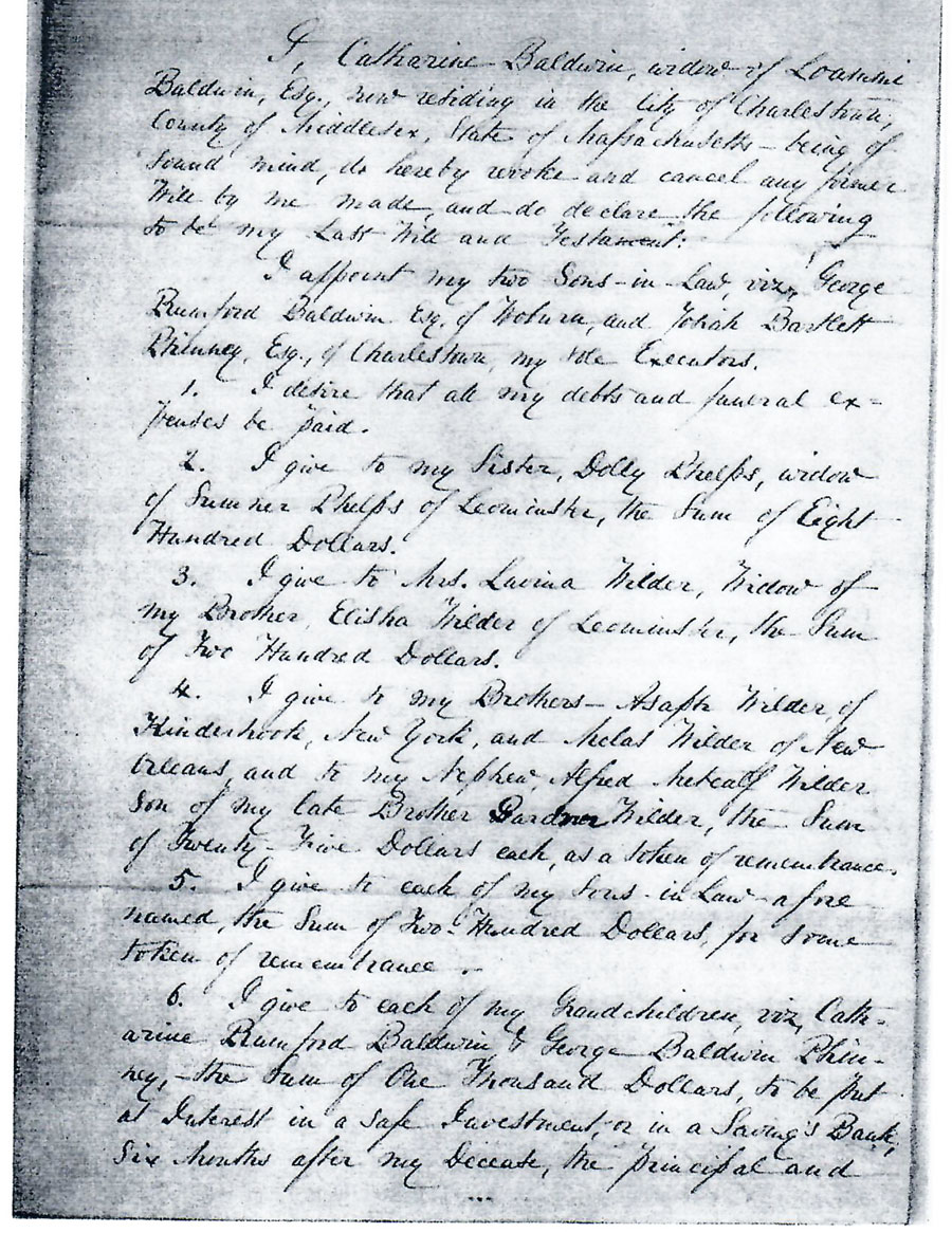
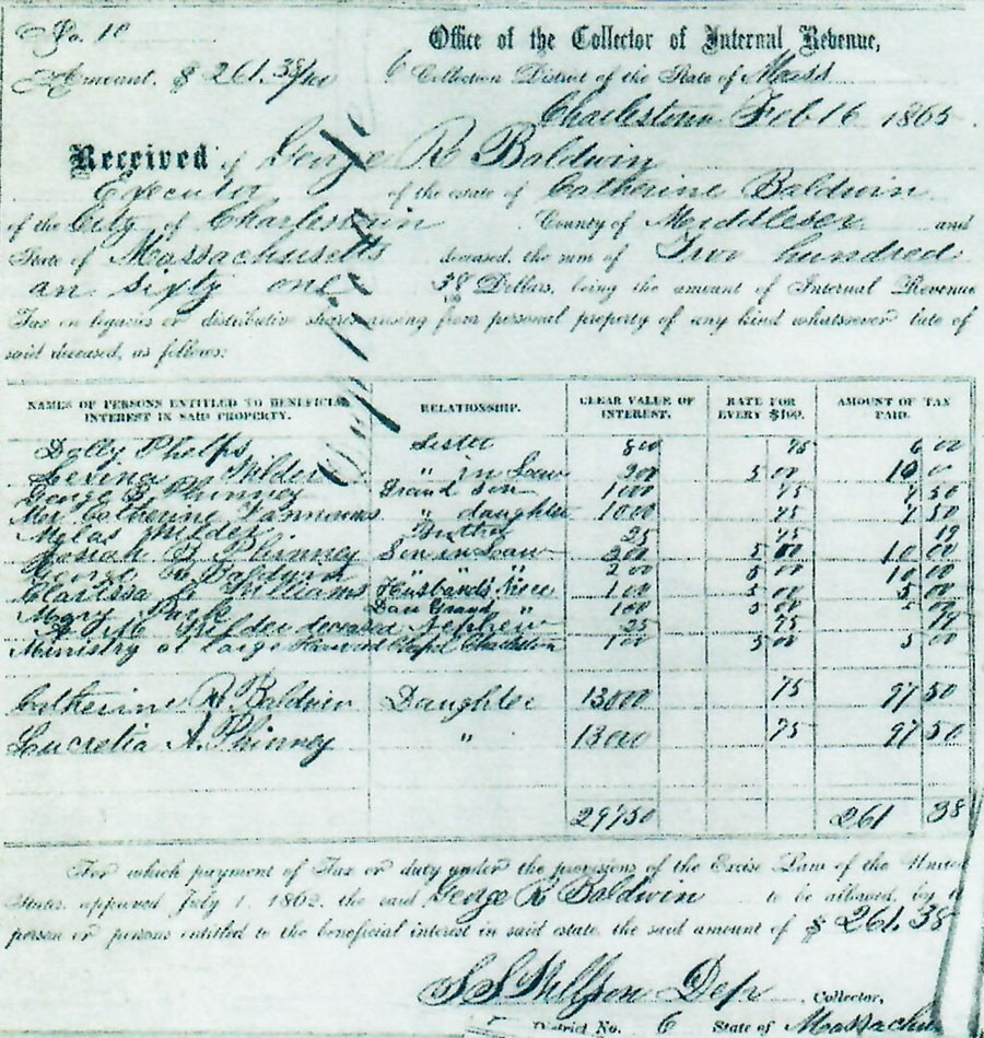
Catherine Baldwin
by Deb Fox
Catherine Baldwin was the second wife of Loammi Baldwin, Jr and he was her second husband. Born in 1787, she married Loammi in 1828. She was 41 and he was 48. The widow Baldwin appears to have stayed unmarried after her second husband’s death in 1838. Her widowhood lasted almost twice as long as her marriage.
Catherine had two daughters from her first marriage to Capt. Thomas Bickford. One of them, also Catherine, married the half-brother of her stepfather, George Rumford Baldwin. The second daughter, Lucretia, married Josiah Bartlett Phinney. Both of these men were appointed by Catherine as executors of her estate. That would have been the reasonable thing to do in 1864. Both daughters had both been married for many years and their husbands could be trusted with this task.
The most interesting “bullet” point in her will is item 9. After all other requests are filled, the remainder of her estate is to be divided between her two daughters, “for their sole and separate use, free from interference and control of their husbands.” She wanted them to invest and live on the interest, but there were no stipulations to that. So how much did they get?
Along with her handwritten will is a copy of the inheritance tax document that was filed by George Baldwin for her estate. The last two names belong to her daughters and show that each got $13,000. That amount of money would be a nice inheritance today, but in 1865 dollars it had to have been a windfall. Were they expecting more? Were they already wealthy, with successful husbands and it wasn’t needed? What did they do with it?
Please enjoy reading the will and tax receipt, pondering what the beneficiaries did with their money. Think also, about how much small changes to women, money, and the power it can bring were slowly starting to change American society.
N.B. According to the website Measuring Worth $13,000 in 1865 would be comparable to $2,560,00 in 2016 using the economic status calculator.
MISCELLANY
Back Issues - Fifty years of back issues of Towpath Topics, together with an index to the content of all issues, are also available from our web site at http://middlesexcanal.org/towpath. These are an excellent resource for anyone who wishes to learn more about the canal and should be particularly useful for historic researchers.
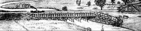
Back Page - Excerpt from an August,1818, drawing (artist unknown) of the Steam Towboat Merrimack crossing the original (pre-1829) Medford Aqueduct, probably on its way to service on the Merrimack River.
Estate Planning - To those of you who are making your final arrangements, please remember the Middlesex Canal Association. Your help is vital to our future. Thank you for considering us.
Museum & Reardon Room Rental - The facility is available at very reasonable rates for private affairs, and for non-profit organizations’ meetings. The conference room holds up to 60 people and includes access to a kitchen and restrooms. For details and additional information please contact the museum at 978-670-2740.
Museum Shop - Looking for that perfect gift for a Middlesex Canal aficionado? Don’t forget to check out the inventory of canal related books, maps, and other items of general interest available at the museum shop. The store is open weekends from noon to 4:00pm except during holidays.
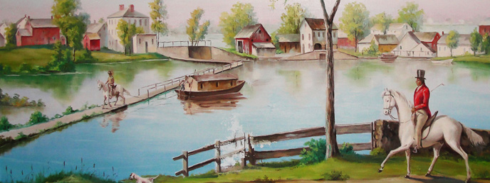
Nameplate - Excerpt from an acrylic reproduction of a watercolor painted by Jabez Ward Barton, ca. 1825, entitled “View from William Rogers House”. Shown, looking west, may be the packet boat George Washington being towed across the Concord River from the Floating Towpath at North Billerica.
Web Site – The URL for the Middlesex Canal Association’s web site is www.middlesexcanal.org. Our web master, Robert Winters, keeps the site up to date. Events, articles and other information will sometimes appear there before it can get to you through Towpath Topics. Please check the site from time to time for new entries. Also, the site now contains a valuable repository of historical information, all the back issues of TT, and an index to all of the articles contained therein, and now can be found there at http://middlesexcanal.org/towpath.
The first issue of the Middlesex Canal Association newsletter was published in October, 1963. Originally named “Canal News”, the first issue featured a contest to name the newsletter. A year later, the newsletter was renamed “Towpath Topics.”
Towpath Topics is edited and published by Debra Fox, Alec Ingraham, and Robert Winters.
Corrections, contributions and ideas for future issues are always welcome.