
Middlesex Canal Association P.O. Box 333 Billerica, Massachusetts 01821
www.middlesexcanal.org
| Volume 58 No. 1 | September 2019 |
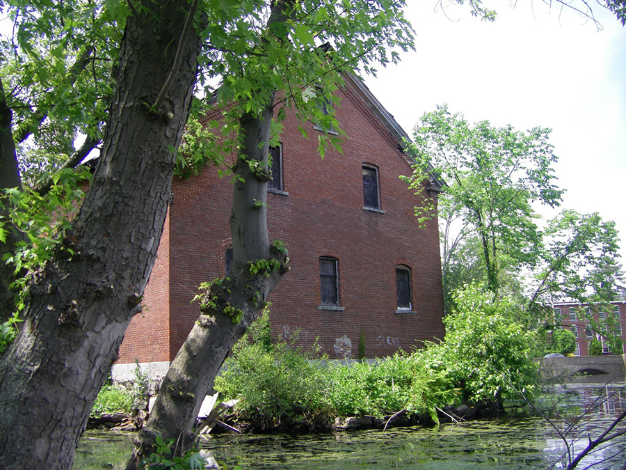
At long last, the necessary permits and approvals are in order and construction may soon begin in conjunction with the effort to transform the cloth warehouse at 2 Olm Elm Street into the MCA Museum. Pictured here is the rear of the warehouse where an observation deck overlooking the Concord River Mill Pond will project outward from the structure. In the distance the Faulkner Street Bridge and the building currently housing the MCA Museum and Visitors’ Center are visible.
Please mark your calendars
MCA Sponsored Events
2019 Schedule
17th Annual Bicycle Tour North, 9:00 A.M., Saturday, October 5, 2019
Fall Walk, 1:30 P.M., Sunday, October 20, 2019Billerica-Chelmsford
Fall Meeting, 1:00 P.M., Sunday, October 27, 2019
Speaker: Dr. Robert M. Thorson, author of
The Boatman: Henry David Thoreau’s River Years
Winter Meeting, 1:00 P.M. Sunday, February 9, 2020
Speaker: TBA
The Visitor/Center Museum is open Saturday and Sunday, noon – 4pm, except on holidays. The Board of Directors meets the 1st Wednesday of each month, 3:30-5:30pm, except July and August.
Visit www.middlesexcanal.org for up-to-date listings of MCA events and other events of interest to canallers!
TABLE OF CONTENTS
MCA Sponsored Events and Directions to Museum
President’s Message by J. Jeremiah Breen
Annual Meeting, MCA Officers & Directors: 2018-2019
A Book Review by Marlies Henderson of This Enchanted Land written Dr. Wayne Peters
From the Wilmington Town Crier an article on the Woburn Volcano by Capt. Larz Neilson
Tay: A Profile of Six Generations by John Ciriello
Part #5 in the Series A Social History of the Middlesex Canal a e-book by Rev. Alan Seaburg
Editors’ Letter
Dear Readers,
As the summer winds down, nights are already getting cooler and possibly frost on the car window this morning! With fall’s arrival comes a return to “Normal”: school, meetings, fairs, Halloween, Thanksgiving, Christmas... Yikes! Getting carried away…
This issue is packed with activities and reading material to transition into the next season, starting with The Fall Bicycle Tour, The Fall Walk, and The Fall Meeting. This fall’s speaker will be Dr. Robert M. Thorson, author of The Boatman: Henry David Thoreau’s River Years so be sure to mark your calendars.
After the President’s Message, descriptions of events, and a recap of the May Annual Meeting, there is a book review by Marlies Henderson, concerning a book written by the father of a past docent and an article (reprinted with permission) by Capt. Larz Neilson about the canal landscape.
As a special feature, John Ciriello has contributed his research on the Tay Family and the Tay Tavern and their relationship to the Middlesex Canal. The biographies compiled by Alan Seaberg from A Social History of the Middlesex Canal continue, and last to wrap up, a poem about the canal by Tristan Macdonald.
As always,
Deb, Alec, and Robert
MCA Sponsored Events and Directions to Museum
17th Annual Bicycle Tour North: On Saturday, October 5, 2019 riders are encouraged to meet at 9:00am at the Middlesex Canal plaque, Sullivan Square MBTA Station (1 Cambridge Street, Charlestown, MA 02019). The ride will follow the canal route for 38 miles to Lowell. There will be a stops for snacks at the Kiwanis Park across from the Baldwin Mansion (2 Alfred Street, Woburn, MA 01801 ~ 12:30pm) and for a visit to the Middlesex Canal Museum (71 Faulkner Street, North Billerica, MA 01862 ~ 3:00pm) The tour will arrive in Lowell in time for the 5:00 P.M. train back to Boston. Riders are able to choose their own time to join or leave the tour by using the Lowell line which parallels the canal. The ride is easy for most cyclists. The route is pretty flat and the tour group will average about 5 mph. Steady rain cancels; helmets are required. For changes and update see www.middlesexcanal.org. It is anticipated that the tour will be led by Bill Kuttner and Dick Bauer.
Fall Walk: The fall walk will take place on Sunday, October 20, 2019. Participants are encouraged to meet at the Middlesex Canal Museum and Visitors’ Center (71 Faulkner Street, North Billerica, MA 01862) at 1:30pm. Pre-registration is not required. The 2½ hour walk will cover part of the Merrimack River branch of the canal in Billerica and Chelmsford, over about 3 miles of generally wooded terrain. Sites visited on the tour will include the recently restored guard lock, the anchor stone for the floating towpath that bridged the Concord River, and many stretches of the watered canal. The walk is jointly listed as a local walk of the Boston Chapter of the Appalachian Mountain Club and the MCA. It is anticipated that the walk will be co-led by Robert Winters and Marlies Henderson. For the latest information please refer to the MCA website, www.middlesexcanal.org.
A Note of Appreciation from Marlies Henderson: Five years ago, Billerica House of Correction inmates prepared the way for a Sunday Fall Walk, as sponsored by the Middlesex Canal Association and the Boston Chapter of the Appalachian Mountain Club: Forty-four participants showed up to follow in the footsteps of Henry David Thoreau who described the same riparian route — also on a Sunday! The visionary wrote in his A Week on the Concord and Merrimack Rivers about the canal: “...in the lapse of ages, Nature will recover and ... gradually plant fit shrubs ... along its borders.” You bet Nature recovered, and I even get help sprucing up the towpath and / or berm side of the canal, lest we completely lose sight of the canal. So, praise those inmates for their efforts — and the Sheriff who made this Community Work Project (CWP) program a priority!
Sheriff Koutoujian told me afterwards that he was glad that the Middlesex House of Correction was able to assist the Association with this cleanup, because the Middlesex Canal holds a special historical significance for the Middlesex Sheriff’s Office; the principal driver in the design and construction of the Canal was Loammi Baldwin, who also happens to be the very first appointed Middlesex County Sheriff in 1780! Sheriff Koutoujian said, “Projects where our CWP crews can help clear trails and public areas for active and passive recreation are projects I want to do more of in the future.”
And indeed, for the past five years, inmates from the Middlesex Sheriff Community Work Program (CWP) have made maintenance of this historic trail their regular business. This fall we celebrate the fifth anniversary of a fruitful partnership: Middlesex inmates get used to being ‘outside’, while preparing Middlesex Canal trails – for the community to get outside!
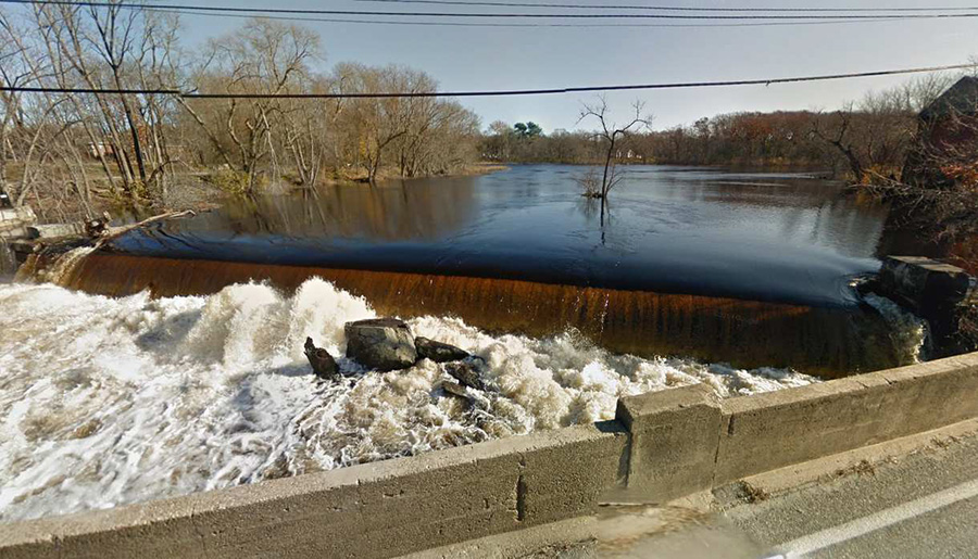
Concord River, Billerica Falls Dam, and Thoreau
Fall Meeting: Sunday, October 27, 2019, at 1:00pm, the Middlesex Canal Association, 71 Faulkner St, Billerica, will host a talk by Robert Thorson, the author of The Boatman: Henry David Thoreau’s River Years. His 2018 talk on Thoreau’s river years is on video in the Internet Archive.1 His October 27 talk will be about the river, the Billerica dam and Thoreau, timely as the US National Oceanic and Atmospheric Administration wants to remove the dam as a barrier to some fish species.2 Dr. Thorson is a professor of geology at the University of Connecticut.3
Suggested readings prior to the meeting
1. The River Years, https://archive.org/details/TheBoatman050218.
2. See Concord River Diadromous Fish Restoration: Feasibility Study: Final Report, Dec 2016, by Gomez and Sullivan, Engineers (Jill Griffiths, P.E.), http://archives.lib.state.ma.us/handle/2452/626310. N. B., the appendices, A - I, are separate files. See also “The 1825 Iron Bolt and the Great Billerica Dam Controversy”, http://middlesexcanal.org/towpath/TowpathTopics-Sept2013color.pdf, pp. 8-10.
3. Professor Thorson, home page, https://robertthorson.clas.uconn.edu/
4. “Agriculture and Industry” by Catherine Clement, Esq. Towpath Topics, March, 1994.
Directions to Museum: 71 Faulkner Street in North Billerica MA.
By Car
From Rte. 128/95
Take Route 3 toward Nashua, to Exit 28 “Treble Cove Road, North Billerica, Carlisle”. At the end of the ramp, turn left onto Treble Cove Road toward North Billerica. At about ¾ mile, bear left at the fork. After another ¼ mile, at the traffic light, cross straight over Route 3A (Boston Road). Go about ¼ mile to a 3-way fork; take the middle road (Talbot Avenue) which will put St. Andrew’s Church on your left. Go ¼ mile to a stop sign and bear right onto Old Elm Street. Go about ¼ mile to the bridge over the Concord River, where Old Elm Street becomes Faulkner Street; the Museum is on your left and you can park across the street on your right, just beyond bridge. Watch out crossing the street!
From I-495
Take Exit 37, North Billerica, then south roughly 2 plus miles to the stop sign at Mt. Pleasant Street, turn right, then bear right at the Y, go 700’ and turn left into the parking lot. The Museum is across the street (Faulkner Street).
By Train
The Lowell Commuter line runs between Lowell and Boston’s North Station. From the station side of the tracks at North Billerica, the Museum is a 3-minute walk down Station Street and Faulkner Street on the right side.
President’s Message - “Dam Removal”
by J. Breen
In August, an official of the MA Dept. of Environmental Protection and of the US National Oceanic and Atmospheric Administration reportedly met with the manager of the Billerica Falls Dam, owned by CRT Development Realty, LLC, in the park aside the dam. The likely subject of the meeting was restoration of diadromous fish to the Concord River. The method of fish restoration preferred by Gomez and Sullivan, Engineers, in 2016 was removal of the dam except for the abutments.1 The Middlesex Canal Association board of directors voted to protect the now 191-year-old dam as part of the future Middlesex Canal State Heritage Park.
Some have said the dam won’t be removed as the Billerica water supply would be impacted. The engineers show that removal of the dam “would not be anticipated to have an impact on the Billerica water supply intake.” 2 Others have said no money for removal is available. But after Hurricane Sandy flooded New York City, the MA Division of Ecological Restoration was granted $4.5 million by the US Department of the Interior to remove ten dams.3 A hurricane flood occurs, and dams are removed in Massachusetts. No reason why this shouldn’t happen again.
Gomez and Sullivan in its 2016 report opined that the dam “does not meet dam safety regulations” as the abutments leak and the embankment is the public Faulkner St.4 The right abutment, looking downstream, is the old fishway, now blocked by concrete and the left abutment is the location of two former waste gates, the very large openings now blocked by wood. Whether the leakage is significant is a matter of opinion. Faulkner Street is higher than the design flood, el. 113.9’ NAVD 1988, of the MA Office of Dam Safety, and its inclusion as a basis for the opinion of Gomez and Sullivan is a mistake.
Geotechnical Consultants, Inc., in its 2015 inspection report found the dam to be in “fair” condition. It recommended remedial measures of more than $100,000.5 If the dam is removed, the river will flow in its ancient channel, worn into bedrock over millennia. Transect T-4 indicates the ancient channel is between 80 and 200’ with a water surface at elevation 100’ NAVD 1988 or less.6 Transect T-4 zero is the northeast corner of 2 Old Elm St7 and 240’ is the Faulkner Mill parking lot. The ancient river, 120’ wide, is 16’ below and 80’ away from the observation deck of the planned visitor center/museum.

The speaker’s topic at the Association’s fall meeting, “The River, the Dam, and Thoreau”, is timely. Eric Hutchins, NOAA fish restoration biologist, and Jill Griffiths, the engineer who wrote the 2016 fish restoration report, have emailed their intention to be there. The presence of many Association members will show support for an alternative to dam removal for restoring the fish. With the visitor center opening at noon, closing at 4, the conversation around the talk could be interesting too.
Notes.
1. Concord River Diadromous Fish Restoration: Feasibility Study: Final Report, Dec 2016, prepared by Gomez and Sullivan, Engineers (Jill W. Griffiths, PE), p. 93. http://archives.lib.state.ma.us/handle/2452/626310 N.B., appendices are separate files.
2. Final Report, p. 96.
3. Press Release, US Fish and Wildlife Service, December 14, 2016, “Two Dams on the Shawsheen River to Come Down”, https://tinyurl.com/y4jlwt2q
4. Final Report, p. 60.
5. Final Report, p. 28.
6. “Transect T-4”, Final Report, Appendix A, p. A-60. http://archives.lib.state.ma.us/handle/2452/626310 N.B., appendices are separate files.
7. Two Old Elm Street is the address of the 150-year-old, former wool cloth storehouse of the Talbot Mills. Its renovation for use as the new Middlesex Canal visitor center/museum is planned. From the new 9’ x 33’ deck overlooking the summit pond of the Middlesex Canal, visitors will be able to observe the dam creating the pond, the iron rings at the entrance of the canal north to the Merrimack at Lowell, and the causeway on the other side of the pond at the entrance of the canal south to the Charles River at Boston. The 400’ floating towpath between rings and causeway can easily be imagined.
May 5, 2019 Annual Meeting - Cinco de Mayo
J. Breen, chair ex officio, called the meeting to order at 1 o’clock.
Betty Bigwood, chair of the nominating committee, stated all directors and officers had agreed to continue serving. Director, Treasurer Emeritus Howard Winkler, was nominated for election to the finance committee. The proprietors re-elected by voice vote the existing directors and officers and elected Howard to the finance committee.
Neil Devins, membership secretary, nominated fifteen members to be proprietors.
The proprietors elected all fifteen by voice vote.
The chair adjourned the meeting at 1:15pm. Betty introduced our speaker, Earl Taylor, President of the Dorchester Historical Society, who talked on “Tide Mill sites from Revere to Quincy”. Refreshments were quesadillas and strawberry shortcake by Traci and Betty. The Audience totaled 33 for a sum of 42 visitors.
The names of the elected officers and board members are as follows:
| J. Jeremiah Breen | President |
| Traci B. Jansen | Vice President |
| Russell B. Silva | Treasurer |
| Neil P. Devins | Membership Secretary |
| Howard B. Winkler | Corresponding Secretary & Treasurer Emeritus |
| Betty M. Bigwood | Director & Museum Building Committee Chair |
| Thomas H. Dahill, Jr. | Director & Artist in Residence |
| Debra Diffin Fox | Director & TT Copy Co-Editor |
| Roger K. Hagopian | Director & Videographer |
| Alec Ingraham | Director & TT Copy Co-Editor |
| Robert Winters | Director, Webmaster, and TT Publisher |
| Honorary Directors | |
| William E. (Bill) Gerber | Leonard H. Harmon |
| Fred Lawson, Jr. | Jean M. Potter |
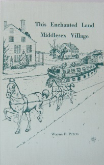
This Enchanted Land: Middlesex Village by Dr. Wayne Peters (1927-2011)
Book review for Towpath Topics by Marlies Henderson
With its title This Enchanted Land, and the cheerful cover illustration of horses trotting in tandem, towing a packet boat, its passengers in deck chairs, lazily on top: This ode to Middlesex Village immediately invites the reader in. Especially if that reader happens to be a fan of the Middlesex Canal, which I am, and obviously, so was its author Dr. Wayne Peters.
His novel came out in 1984, but it’s like time travel. It takes you back to the winter of 1833 and then even deeper in time, to the summer of 1823. These were the heydays of the Middlesex Canal; it was the dawn of the Lowell Mill Girls’ era, and when New England winters were worth writing home about. Particularly for remote farms. Embrace the themes of isolation, passion and fate! Illustrated with twentieth century photos of historic structures and artist renderings, it brings the past to life.
After ample introductions and a listing of historical facts, the fiction takes off, and soon a sense of impending doom haunts the reader. Finally, not until the Acknowledgements, Peters credits Edith Wharton “for blazing the trail for this novel”. [Note: Edith Wharton (1862-1937)]
Indeed, unmistakably, Ethan Frome (1911) inspired Peters’ character Jim Creech and plenty of the plot lines. Some components differ; Zeena is barren but Lu bore three children; contrary to Frome, but as the author’s ancestor (!), Creech is a blacksmith. Sure enough, the Ethan Frome drama takes place between 1890 and 1900; almost seventy years after the time in which Peters’ story is framed: Before the first wheel of the Merrimack Manufacturing Company was set in motion, and while the canal was frozen solid, Middlesex Village was much like Wharton’s isolated Starkfield. Lucretia is Zenobia; her cousin Mindy is Matty. The Widow Adair is the widowed Mrs. Ned Hale.
Other similarities abound, including the novel structure and point of view and its variations; from first person to a third, omniscient person. More than being a fly-on-the-wall, we get to read the minds of different characters - even more so in Peters’ novel than in Wharton’s. Peters actually invites a measure of mercy into the disastrous plotline; cruelly, Wharton keeps her characters alive, trapped in a deadlock, establishing Sartre’s No Exit’s (1944) philosophy that ‘Hell is Other People’.
In Peters’ version, all three characters in the, no less tragic love-triangle eventually find their more or less violent death, one after the other: A drowning in the Merrimack, a suicide, and ripped apart by a bear. Their fictional voices ring on, putting a spell on the remnants of the Middlesex Canal – keeping its memory alive. I admit to leaving readers groping for plot and action, but the books are worth a read, and I don’t want to spill any of these dark beans.
It is however noteworthy that Peters’ son Jim recounts what prompted his father to write the book: When across the street from his Middlesex Village home on Princeton Boulevard a new development caused the bulldozing of several historic structures, including Jesse Smith’s farm, Peters decided to write a book, and thus help preserve history.
Several historic structures including Jesse Smith’s Farm
Another anecdote Jim shared with me was that a local Indian legend, The Bride of the White Canoe; a love-triangle’s violent ending, with voices allegedly still spookily ringing, inspired the spine-chilling finale; fit for Halloween.
Thank you Dr. Wayne Peters for delightfully enchanting The Village!
 Sources:
Peters, Wayne R. - This Enchanted Land. Martin Publishing Company, 1984.
Wharton, Edith - Ethan Frome. C. Soubner, New York, 1950
Browne, Waldo G. - Tales of the Penacook. Rock Village Publishing, 2007
Editor’s Note: If Marlies’ book review has piqued your interest, This Enchanted Land: Middlesex Village is available for sale at the Middlesex Canal Museum store in North Billerica or through the MCA website. If you prefer not to purchase the book but would still like to read it, this volume is among a limited number of books available for loan through the MCA’s lending library.
About the Author: Wayne Robert Peters was born in Cherokee, IA on May 1, 1927. He enlisted in the Navy at the age of 17 and served during WW II aboard the USS Charles P. Cecil. Following his enlistment in the service, he received a Bachelor’s Degree in Education from Buena Vista College in Storm Lake, IA, where he also experienced success as a football player. Wayne earned his Master’s Degree at Drake University in Des Moines, IA and in 1964, his PhD from the State University of Iowa. He began his career as a teacher/coach in Barnum, IA and later as a principal in Coralville, IA before working as Superintendent of Schools for school districts in Cosgrove, IA; Harvey, IL; Lowell, MA; and Holbrook, MA. While in Lowell he served on the School Committee and on the City Council. In August of 1950, Wayne married Jeanne Lucille Ollerich. He passed away in Naples, FL on July 13, 2011 at the age of 84 and was survived by his wife of 61 years and nine children. (Ref: Lowell Sun, July 17, 2011) Wells, a book about a coastal town in Maine was also authored by Dr. Peter. His son, James, married U.S. Senator Paul Tsongas’ sister, Vicki, and did volunteer briefly as a docent at the Middlesex Canal Museum and Visitors’ Center.
Note: Reprinted by permission by the Wilmington Town Crier
By CAPT. LARZ NEILSON, Founder of the Town Crier
Few people who drive to Woburn by way of Main Street realize, when they near the Woburn - Wilmington line, that they are driving through an ancient volcano.
Alongside the road is a cliff of basaltic rock. On top, where it may be seen in springtime, is a slight depression, which fills with water in the spring rains. This is the throat of an ancient volcano, up which was thrown hundreds of thousands of tons of molten lava, all of this having been hundreds of millions years ago.
There is no danger that the old volcano will ever erupt. It can be recognized for what it is only by persons trained in geology.
The history of the land which is now Wilmington began about 500 million years ago when what is now New England emerged from the ancient seas. Beneath the land which emerged, there was hot molten material known as magma, which kept trying to force its way to the surface. It would explore and find cracks, and then cool into enormous masses of igneous rock - rock which we today call granite.
The Quincy granites were formed at this time, as were granites all over New England. The type and grade of granite depended entirely on how close to the earth’s surface the molten magmas were able to get. If the magma was close to the surface, it cooled rapidly and formed a fine granite. If it did not get too close, it took longer to cool, and became coarse granite.
In the period of which we are writing, there was no Boston Harbor. It was yet to be made by the sinking of the Boston Basin, but it was as a direct result of that sinking that the volcanoes of Eastern Massachusetts were formed volcanoes in what is now Woburn, Winchester, Reading and Wilmington.
After the granites of which we have spoken had been formed there was a new geologic era in what is now the Boston suburbs, one in which the pudding stones of Roxbury were formed. The seas had again covered the land. Slates were formed in some places, from clays that were deposited on the bottom of that sea. In Wilmington, the soils that were deposited became schist, although not much of it exists today. That which does can mostly be found in South Wilmington from Wood Hill, over by the Burlington line, to Suncrest Acres, off West Street.
Schist is a soft stone which breaks easily into layers, an important feature, for it was this tendency together with others which led to the bankruptcy of a Nevada firm which tried to drill through the rocks of Wilmington’s volcano.
The hard coals of eastern Pennsylvania and the soft coals of western Pennsylvania and other regions were laid down during this same period, in which the pudding stones and schists were laid down in New England. Hence, the period is known as the Carboniferous Period.
When Boston sank
All of what today is Boston Harbor and the nearby cities once sank for thousands of feet, as the result of the weights of rocks in the area. The hole which resulted (and which has since nearly filled) can easily be marked off, in such places as Malden, Arlington and the Blue Hills.
The sinking of the land in and near Boston was a gradual process which took thousands of years. There was great stress and strain in the nearby hills. Cracks and curves appeared in the rocks.
Through these cracks, the molten rock beneath found a way to escape to the surface, and dozens of volcanoes appeared around Boston.
In the vicinity of Woburn, there were dozens of volcanoes, all pouring thousands of tons of lava and basalt upon the surface of the earth. Three volcanoes surround what is now Woburn Center. Horn Pond Mountain, now the reservoir of the City of Woburn, was a volcano. Today’s pond is in the old volcano mouth. The hill known as Blueberry Hill, on the Woburn - Winchester line, was a volcano. In the early to mid 1900’s, a quarry there provided hundreds of thousands of tons of rock for road building and railroads in eastern Massachusetts.
The northernmost of these volcanoes was just north of the Woburn - Wilmington line, today called Cook’s Hill.
It is a mere shadow of its former self, for the ice ages, which began about one million years ago, ground down what had been an imposing mountain into a small hill but the lava rock, the basalt, and the throat of the volcano can still be seen.
The most interesting point to be seen without climbing the hill is the cut where Route 38 runs through the hill. This cut was done about 1927, when Main Street was relocated. Previously, the road ran around the hill and around a pond known as Squaw Pond, which was filled in at that time.
The name Squaw Pond arose from the accidental killing of an Indian woman there in 1705, which resulted in the Harnden massacre but that is another story.
The contracting firm which took the job of cutting through Cook’s Hill and building the new road went bankrupt because of the nature of the rock left by the volcano. Because the hill is a mixture of granite, schist and basalt, the drills refused to go into the hard rock and instead bent and turned into the softer schist. Unable to maintain its drills and unable to finish the job, the company went bankrupt.
Atop the hill for many years, there was a stone chapel, built by a Greek - American. He had built it with the intention of it becoming an Orthodox Church. But it was abandoned, and during Prohibition it became a hangout for bootleggers.
Tay: A Profile of Six Generations
by John Ciriello, March 3, 2003
The Tays were an integral part of the historic fabric of early North Woburn. Their name was passed on from generation to generation for nearly 300 years in this area.
They were a family which was rich in military and political influence, were socially respected by their community and an integral part of our local history. They were truly representational of what our forefathers believed in: hard work, community involvement, and patriotism!
My interest in the Tay family’s genealogy started during my research on the history of my house. It seemed that the more I learned about this fascinating family, the more questions I had about them.
Artifacts uncovered during work on my property disclosed layers from different time periods of those who lived here. Each small fragment of pottery had a story of its own to tell. I was able to determine when it was made and used, what socio-economic status the people who used it had, and what use it may have performed. Leather soles from handmade shoes found throughout the site whisper about people who once owned them. Where those shoes may have walked or what they may have seen is a secret only they know. The black, charred insides of a white clay smoking pipe appears as if its owner has just finished smoking it a few moments ago and then tossed it aside for me to find.
Three small round clay marbles once heard the voices of children’s laughter and then watched them grow up from a spot in the tall grass where they were dropped by them many years ago. The mightily old hand-hewn beams of the old house itself also speak sometimes. They hint at my house’s age but refuse to surrender the secrets they overheard from generations of families which they sheltered. One learns to sharpen their senses by gathering and deciphering miscellaneous pieces of this very large “puzzle”.
I’ve learned that each piece is like a fingerprint in time.
Perhaps one day far in the future, someone may discover something that I’ve lost in the backyard, pick it up and wonder who I was.
Tay
The Profile of Six Generations
The Tay surname is very common in Woburn’s early town records. The actual origin of the family is unknown, but suggest a British genesis. Early writers point out that the old pronunciation of Tay was “toy.” (Cutter, Page 7) This suggests a possible British accent. In fact, there’s an entire area in Scotland known as the “Tay Valley.”
The earliest mentioned Tay, was a distiller named William who is known to have been in Boston in 1643. His spouse Grace Newell, was from Roxbury, and they married on September 14, 1644. William received a “single share” of land which was a ten-acre grant in what is known today as Billerica in 1656. Two years later, he was granted an additional 56 acres, described as: “a house standing upon it, bounded on the east and south partly by ye comons.” In 1664, he is listed as the town’s clerk. It’s believed that William, his spouse Grace and their seven children, left Billerica and fled to Boston some time later because his name does not appear on the “Garrison List of 1675”. This may have happened just before the Indian alarms of that same year and they may never have returned to Billerica because William’s death was recorded in Boston in 1683, not in Billerica.
William’s son Nathaniel inherited the family’s property in Billerica upon his father’s death and it was later sold on April 8, 1691. They may have moved to North Woburn soon thereafter. (Hazen, Page 148) Nathaniel married a girl by the name of Barthsheba Wyman, daughter of Lt. John Wyman of Woburn on May 30, 1677, and they had 7 children together.
Upon Nathaniel’s death, his son Lt. William Tay I, became the sole executor of his father’s last will and testament. (Probate 22158) William inherited the family homestead which was located on the easterly side of Main Street, at the northeast corner of East Nichols and Main Street in North Woburn. (Cutter, Page 53.)
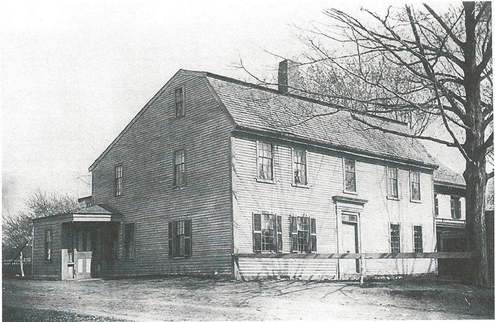
The Samuel Tay Homestead once located at the corner of East Nichols and Main Streets.
On July 11th, 1726, a son was born to William I and his young wife Abagail (Jones). The baby was named after his father and became one of thirteen brothers and sisters. Not much is known about William Jr.’s childhood, except for the fact that he was most likely a typically inquisitive and exploratory youngster. His family lived across from an area once known to the locals as Berry Meadow (Cutter, Page 5). There, he must have played in the rolling fields among the groves of abundantly growing wild berries which earned the location its name. Berry Meadow Brook ran through the field (today’ s Halls Brook) and little William must have delighted in exploring along its banks, collecting frogs and turtles and perhaps returning home covered in mud from head to toe. Since their house was located very close to the old road, (today’s Main Street) he would have met travelers daily as they made their way past the Tay Farm to points north and south on what was already one of early Woburn’s first busy thoroughfares (known then as “the Great Road to Andover”).
When William was 12 years old, his brother Samuel was born. Samuel followed in his father’s military footsteps, and grew up to be a Sergeant during our country’ s war for freedom. He was one of the men who marched in Captain Fox’s 2nd Regiment, toward Concord and Cambridge on the alarm heard on April 19th, 1775. (Military Rec’ds, Woburn Public Library) He possessed quite an impressive military history, becoming a Lieutenant in 1775, Captain in 1776, and then a Major in 1784. (Cutter, Page 53) Upon the death of his father in 1780, Samuel inherited the family’s homestead. (Probate #22163)
Together with his wife, Sarah (Johnson) whom he married in 1769, they went on to raise their own family there. Samuel’s wife was almost certainly not alone in raising and caring for their large family though. The Tays apparently owned a servant, a black woman named “ Kate”. Not much is known about this mysterious woman except for the mention in the local newspapers of when they discovered her lifeless body laying in a nearby pasture. At the time of her death, all that is mentioned is that she was “elderly” (Cutter, Page 53) and that body went undiscovered for quite some time.
Samuel’s older brother, William Jr., purchased his own piece of land in 1752, at the young age of 26. This parcel was just a short distance north on the same old road. In 1798, his property was described as containing 255 acres, 2 dwelling houses, one with a shop attached, 2 barns, and 1 horse shed. (Cutter, Page 54) The farm was located at what is today, the Woburn/Wilmington boundary line. Young William Jr. married Susana (Jones) of Marlboro, and over time they had 7 children together.
William Jr. also held the title of Lieutenant, and is remembered for his bravery during the British and Minutemen skirmish on April 19th, 1775 in Lexington and Concord.
On the morning of April 19th, 1775, William is said to have been awakened from his sleep by an alarm which sounded on the “sudden march of British troops towards Concord”. The British soldier’s intention was to destroy the colony’s magazine deposit which was located there. Along with 180 well-armed townsmen, they marched hastily toward west Woburn, and then over what is known today as Woburn’s “Battle Road” toward Lexington. Upon their arrival, the men became angered by the bloody massacre which had fallen upon their unsuspecting neighbors. The men witnessed what is described by witnesses as “cruel butchery of the elderly, bedridden new mothers, the poor and the helpless”. Upon their retreat, the British were said to have left behind a trail of devastation and destruction. The minutemen became enraged, and a pursuit of the British soldiers ensued towards Boston. William Jr. and several others eventually arrived at a location in Charlestown. There, they were suddenly fired upon from within a nearby house. Three British soldiers had planted themselves inside to ambush anyone passing close by.
William Jr. and his group immediately returned the gunfire and managed to kill two of the British soldiers. They rushed inside and captured the remaining one. The commotion attracted other fellow minutemen who were nearby, and during the confusion of securing the irate prisoner, a lieutenant named Joseph Howard from Concord, carried off the captured British soldier’s gun as his souvenir. A petition with the General Court of Massachusetts was filed by William for the return of that firearm which he believed was rightfully his. This request was granted by the court in May, 1775, but as of September of that year, it’s documented that Mr. Howard still hadn’t surrendered the prized firearm to William Tay. It’s a mystery whether William ever actually received his souvenir, but his complaint to the General Court in September of 1775 is well documented in grievance records and he begs that the law “rightfully and legally” retrieve his awarded property. (Frothingham, Page 368)
In May of 1750, William Jr. and Susanna had their first son, whom they also named William. William III was one of six children who would also grow up to hold the proud military title of a lieutenant. At some point, an inn was established by the Tays as an additional source of income for their family. Busy Andover Road (today’s Main Street), passed right by their farm, and would guarantee an ongoing flow of customers for their new business. Thus, a familiar establishment, becoming known as the Tay Tavern, came into existence and the timing couldn’t have been any better!
In 1794, Boston was about to embark upon its first truly monumental engineering project,… one that more aptly deserves the title of “big dig” than our modern one, ... the construction of the Middlesex Canal.
In 1794, a surveying team was sent out to take measurements of two possible routes considered for the new proposed canal. A “western” or “eastern” passage would connect Lowell to Boston and it was being evaluated by surveyors and engineers. The western route would take the canal right past the Tay homestead and tavern. The Tays surely witnessed these teams of strangers arriving and assembling close by on the road in front of their farm. There, the men discussed, measured and wrote down detailed notes of their findings.
The surveyors measured slopes, heights, and dimensions of the existing topography in the area near the Tay farm in order to evaluate whether the western route would be better suited than the eastern one.
In May of 1795, the surveyors recorded having tracked what they termed “the correct level” for the new canal. Since the water had to be almost at a constant “level”, with just a slight pitch southerly, extremely precise measurements were essential. In written documentation, the engineers arrived near the Tay homestead and “hit the level” that they were seeking at “the rocky points a little north-west of Tay’s Tavern” (probably near today’s Jimmy’ s Gas Station in Wilmington), and then again at his “Hop Kiln.” They arrived at a rise in the road, described as a “nole,” which was “10 feet above the level required, just south of Tay’s Tavern” (which is the steep rise in Main Street just south of North Maple street today) and then proceeded down into a “valle” (or valley known at that time by locals as an area called “Sandy Bottom”) until they reached the “level” again. (Baldwin Collection, box 2 folder 2) The Canal Proprietors eventually decided to use this westerly route by the Tays for the canal and in 1800 construction began along this section along this section. The canal’s dimensions would be 30 feet across at the top, 20 feet across at the bottom and the water’s depth was only 3 feet.
The entire project was dug by hand, with the assistance of work animals which helped haul soil. Many new challenges were met along the way since a project of this magnitude had never been undertaken before in the state. The canal was required to cross over rivers and streams without intermixing the water . This was accomplished with the use of aqueducts and culverts. Blasting was used in areas where rock prevented hand digging and the first eminent domain land taking was executed and recorded in Massachusetts. When completed, the canal boasted the construction of 50 bridges and a series of 20 locks.
Passenger boats and commercial barges were pulled by horses, mules or oxen from the abutting “ tow path” by way of a rope which was secured to a metal ring placed 1/3 of the length back from the front of each vessel. Workers for the project arrived from afar and farmers living along its length found badly needed employment as well.
A note in the “Regulations of Acceptance,” dated June 13, 1795, mentions Woburn’s well-known citizen, Loammi Baldwin. In it, it states: “June 6, 1795, voted that the Hon Loammi Baldwin Esq be superintendent of digging the canal from Mystic Pond to Johnathan Beard’s house in Wilmington.” (Baldwin Collection, Box 2 Folder 2)
The Tays capitalization on the canal project was great. Tay family members were directly employed in its excavation and in a note dated September 14, 1799, the names of William, Samuel and Benj. Tay appear on a “List of names of the people who wish to apply for work on the canal traveling through Woburn.” (Baldwin Collection, box 3 folder 3) A later memorandum, dated December 8, 1800 states, “ Tay and Hunt’s job between Wilmington line down by Converse place progresses very well.”
Their tavern provided housing for the migrant workers who needed housing during construction. (Leander Thompson, Woburn Journal, 3/27/1885) Upon the canal’s completion, the tavern became a lodging place for its travelers, and also a place for “changing horses” (or sometimes mules) of the passage boats. (Woburn News, April 25, 1891)
In October of 1800, a memorandum was sent to the directors of the canal regarding the purchase of land from Mr. Tay for a portion of the canal’s route. In this memorandum, the negotiator wrote that the agreement which was discussed, acquitted the Canal Proprietors from “all damages Mr. Tay may ever experience from the depositing of earth, the water that may happen to flow into his cellars, or injury to his cellar walls”.
The price for 110 rods of land, 5 rods wide through his property needed for the canal prompted much debate between the two men. They finally arrived within a difference of just one dollar. Tay wanted $13.00 per rod, but the canal negotiator’s highest offer was $12.00 per rod. The date of this memorandum was October 27th, 1800, and a final decision was expected to be made that same day on whether the deal was “on or off.” (Baldwin Collection, box 3 folder 3) On November 11th, 1801 William Tay III and his wife Hannah, sold this parcel to the Proprietors of the Canal for much less money. The record at the Cambridge Registry of Deeds shows that William received a sum of $200.00 for the 110 rods. (Grantor Index 147/143) That comes to only $1.82 per rod! Why such a drastic decrease from the previous higher offer being negotiated? Had the threat of taking land by eminent domain become a strong bargaining tool which worked in favor of the Canal Proprietors?
By 1800, the canal’s excavation near Tay’s farm was making great progress. Just south of Tay’ s house, the canal had to cross from the western side of Andover Road (Main Street), to the eastern side. At this previously mentioned “nole,” the canal passed about 10 feet below the level of the road. At this location a wood bridge was constructed and was known by the locals as “Tay’s Bridge”. In December of 1800, workers rushed to complete as much work on the bridge as possible to avoid the approaching cold winter months. December 12th’s minutes of the Canal Committee state that; “The bridge over the highway at Tay’s Tavern is to be prepared and stedded down. The stones for the abutments will be brought this winter in order to prevent delay and interruption in the spring.” (Baldwin Collection, box 2 folder 9)
The following spring, on March 16th, 1801, a letter was sent to the carpenter hired to build the bridge, Mr. Hall. The letter stated; “Let 6 or 7 carpenters come on to Woburn as soon as possible to put up the bridge at William Tay’s. Send on the planks for Tay’s bridge, letting each be broader at each opposite acute angle, put on the coppers and 2 outside stringers.” (Baldwin Collection box 3 folder 14)
Stop gates were used every so often along the length of the canal in order to stop the flow of water for any repairs that may have been required downstream. One of these gates was installed at Tay’s Bridge. In the minutes of Committee of August 3, 1801, it states that there is to be “one by Tay’s bridge,” and that “these gates are not to be expensive or heavy. There must be a sill across the canal and the gate above the two leaves may be only three feet high where they are placed against a bridge. The abutments will afford them support. They will of course shut toward the place where the highest banks are.” (Baldwin Collection box 1 folder 1)
A large natural outcropping of stone ledge was located across from the Tay homestead and it may have caused some problems during the canal’s excavation. This northwest point located immediately after Tay’s Bridge must have required removal of stone. The following minutes from a meeting of Committee of Operation hints at the issue; November 27th, 1801, “ Ordered that as the work closes, the tools and implements be collected, listed, and secured; that the month and day laborers be continued this season as long as the superintendent and overseers shall consider it expedient under all circumstances; but at all events, to remove the ledge at Converse Place and the one at Tay’s. (Baldwin Collection box 2 folder 10)
But the strangest story about the Tay family by far is this one ... A very brief paragraph found at the Woburn Public Library reads, “He was in the Revolutionary War (William III), his son William (IV), lived nearby just where the old road came out (North Maple Street). One Robert Wood, a brother of Benjamin, Isaac, and William, lived with this Mr. Tay for several years, having no stipulated pay, other than his board; he was never married, was rather peculiar in habits, and considered not shrewd intellectually, yet is said to have managed so that after Mr. Tay’s death, he came into possession of his real estate. He filed a bill for services rendered during his stay with him sufficient to cover the value of the place, which was granted by the court, and so the heirs were left minus.” (Newhall’ s Article No. 5)
As strange and improbable as this statement may have read, the truth behind it explained what really occurred.
Upon the death of Lieutenant William Tay III in 1829, his Last Will and Testament was due to be executed by his son William IV, the appointed sole executor. Many well-known names from Woburn’s past were present at its reading; Charles Thompson, Benjamin Wyman, Stephen Nichols, Jeremiah Converse, Joseph Gardener, and Archelaus Tay.
The inventory of William’s personal estate was extensive. He had amassed a great deal of wealth in his lifetime, partially attributed to the income generated by his large farm and successful tavern business. In total, his probate records show that he owned 269 acres of land and many personal household possessions. (Probate 22165)
Although the Tay Tavern itself was never mentioned by name, the inventory does show an unusually high number of chairs (20) and tables (8), which is not typical for a small residential home of that time.
Then on October 7, 1828, a petition to remove William IV as the sole executor of his father’s will, was filed in Middlesex Probate Court, and stated that he is “unfit” to execute it.
Joseph Gardener, friend of the family and a town selectman, was appointed by the courts as the new executor of the late William III’ s will. A new inventory of the deceased’ s possessions was ordered by the Honorable Samuel Fay, Esq., Judge of Probate in Middlesex County, Cambridge. Josiah Tay, Charles Carter and Ezra Kendall are responsible for the task of carrying it out. What happened?
In a letter dated June 27, 1828, we learn what transpired. A petition signed by 17 community members was submitted to Woburn’s selectmen and it states; “We the subscribers certify that in their judgment, William Tay of said town, does by excessive drinking, so spend, waste and lessen his estate, as thereby to expose himself and family to want and suffering circumstances, and we think a guardian ought to be appointed to said Tay.”
In July a letter was sent to the Honorable Samuel Fay, Esq., Judge of Probate in Cambridge by the town selectmen. In it, it states that William “endangers and exposes the town of Woburn to a charge or expense for his and their maintenance and support.” They request that the court appoints a guardian for him immediately.
On August 28, 1828, the court appointed Joseph Gardener as the legal guardian for William and his estate. Over time, debts against the Tay Estate had accumulated and needed to be settled in William’s death.
On August 11, 1829, Joseph Gardener became legally empowered and licensed by the court to sell off some of Tay’s land in order to pay for his own guardianship fees, which had amounted to $1,191.48, and $30. more for incidental charges. Records show that William’s Real Estate at that time was worth $2,400.00. (Probate 22166)
In December, 1832, Robert Wood’s character enters our story. Wood filed for damages with the Supreme Judicial Court in Concord, for the amount of $508.11 which he claims is owed to him by said William Tay’s Estate. He requests that legal fees be added to the sum as well. He goes on to state that William IV should be taken to the Cambridge or Concord “gail” (jail) and held there until he agrees to pay the debts owed.
Accompanying Mr. Wood were Stephen Nichols, Oliver Tay, and Samuel Leathe, who swore to have acted “faithfully and impartially” in their appraisal of William IV’s Real Estate. They place a value of $525.00 on the following Tay land; a parcel called “Sandy Bottom”, sandwiched between Andover Road (Main Street) and the Middlesex Canal, totaling 3 acres. Also, the “house lot, bound on the north, east and west by land owned by Cyms Right and south on the road that leads to New Boston (Step Rock Rd, now North Maple St), with the buildings thereon, containing 1/3 of an acre, more or less.” Also, another parcel south of this “back road,” containing 6 3/4 acres, then 3 more acres east of these properties bordering northerly on a swamp.
On December 22, 1832, Moses Richard, Deputy Sheriff of Middlesex County, executes that Robert Wood “seizes and possesses” the above listed “lands and tenements,” in order to satisfy the debt and costs amounting to the sum of $525.02, which includes legal fees, travel and appraisals. Suddenly we realize that the earlier improbable story is indeed true!
Two years later, on April 22, 1834, William Tay IV writes a letter from a location in Lowell. He petitions the court to remove Joseph Gardener of Woburn as his guardian. He explains that guardianship is no longer necessary, due to the fact that he has “reformed his habits” and was perfectly capable of taking care of himself and his estate. He explains that neither Woburn, nor any other town, is “exposed to expense” for his support. His letter is supported by an accompanying one from the Woburn Selectmen, who confirm his claims. (Book of Executions, Page 190)
The Tays played a major role in North Woburn’s early history, as they helped sculpt the future of the city through their social involvement and influence. Sadly, the surname is said to have become “extinct” in 1930, with the passing of the last Tay family member, ... Miss Anna F. Tay. (Newhall, Page 94)
Research on the Tay surname and history associated with Woburn is constantly ongoing and updated.
Works Cited:
Baldwin Collection, Baker Library, Harvard Business School
Book of Executions, Cambridge Registry of Deeds, p. 190
Grantor Index, Cambridge Registry of Deeds, 147/143
History of Billerica, Rev. Henry A. Hazen, 1883
Mogan Library, Lowell, MA (Diagram of Tay’s Bridge)
Newhall’s Articles, Woburn Public Library, Book #W93N53W.A
Probate Dockets, #22158, 22163, 22164, 22165, 22166, Massachusetts Archives Building, Boston, MA
Woburn Historic Sites and Old Houses, W.R. Cutter, Book #W91C9W
Woburn News, Cyrus Thompson, April 25, 1891
Note: After a visit to the Museum, the author was inspired to write the following poem.
Middlesex Canal
by Tristan Macdonald
“This canal …is the oldest in the country, and has even an antique look beside the more modern railroads…but in the lapse of ages, Nature will recover and indemnify herself, and gradually plant fit shrubs and flowers along its borders…..This all works pass directly out of the hands of the architect into the hands of Nature, to be perfected”
-Henry David Thoreau
Middlesex Canal This canal is now divided, devolved |
MISCELLANY
Back Issues - More than 50 years of back issues of Towpath Topics, together with an index to the content of all issues, are also available from our website http://middlesexcanal.org/towpath. These are an excellent resource for anyone who wishes to learn more about the canal and should be particularly useful for historic researchers.
Estate Planning - To those of you who are making your final arrangements, please remember the Middlesex Canal Association. Your help is vital to our future. Thank you for considering us.
Membership and Dues – There are two categories of membership: Proprietor (voting) and Member (non-voting). Annual dues for “Proprietor” are $25 and for “Member” just $10. Additional contributions are always welcome and gratefully accepted. If interested in becoming a “Proprietor” or a “Member” of the MCA, please mail membership checks to Neil Devins, 28 Burlington Avenue, Wilmington, MA 01887.
Museum & Reardon Room Rental - The facility is available at very reasonable rates for private affairs, and for non-profit organizations to hold meetings. The conference room holds up to 60 people and includes access to a kitchen and restrooms. For details and additional information please contact the museum at 978-670-2740.
Museum Shop - Looking for that perfect gift for a Middlesex Canal aficionado? Don’t forget to check out the inventory of canal related books, maps, and other items of general interest available at the museum shop. The store is open weekends from noon to 4:00pm except during holidays.
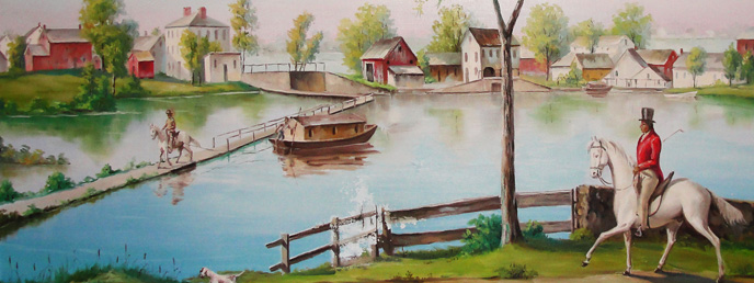
Nameplate - Excerpt from an acrylic reproduction of a watercolor painted by Jabez Ward Barton, ca. 1825, entitled “View from William Rogers House”. Shown, looking west, may be the packet boat George Washington being towed across the Concord River from the Floating Towpath at North Billerica.
Web Site – The URL for the Middlesex Canal Association’s web site is www.middlesexcanal.org. Our webmaster, Robert Winters, keeps the site up to date. Events, articles and other information will sometimes appear there before it can get to you through Towpath Topics. Please check the site from time to time for new entries.
The first issue of the Middlesex Canal Association newsletter was published in October, 1963. Originally named “Canal News”, the first issue featured a contest to name the newsletter. A year later, the newsletter was renamed “Towpath Topics.”
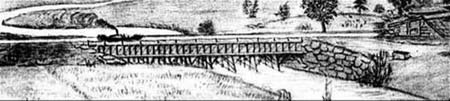
Excerpt from an August 1818, drawing (artist unknown) of the steam towboat
Merrimack crossing the original (pre-1829) Medford Aqueduct,
probably on its way to service on the Merrimack River.
Towpath Topics is edited and published by Debra Fox, Alec Ingraham, and Robert Winters.
Corrections, contributions and ideas for future issues are always welcome.
Part #5 in the Series: A Social History of the Middlesex Canal,
an e-book by Rev. Alan Seaburg
NOLAN JONES
Nolan T. Jones (1927-2015) served as President of the Middlesex Canal Association for 18 years. He first held the office from 1983 to 1985 and then again from 1994 to 2010.
He loved what he did there, the people he worked with, and the company, and so remained at MITRE until he retired. The two projects of which he was most proud of during his engineering career were helping with the early development of computers, and being involved with MIT’s Project Whirlwind I, which was a research venture to construct a flight trainer that could actually simulate flight for pilots.
For almost 22 years Nolan, his first wife Beverly McCoy, and their children lived in Winchester, Massachusetts. There, he was involved in the activities of the local Unitarian Church, the Middlesex Canal, and the Boy Scouts. That latter organization, in appreciation of all his support over the years for their various projects gave him their “Silver Beaver” award for distinguished service. After the untimely death of his wife in 1981, he married some time later, Joan Lloyd Born. Together they enjoyed being active in the Middlesex Canal Association, the politics of the Democratic Party, and traveling around America, Canada, and Europe. And of course, they liked inspecting historic canals. Sadly, the last five years of his life was spent battling the effects of a stroke; he died at 88 in Sacramento, California on July 14, 2015.
For an excellent overview of his years as President of the Middlesex Canal Association, as well as his many contributions to understanding its history, which include taking aerial photographs of the entire canal, leading walks along its route, the celebration connected with its Bicentennial, and the establishment of its Museum, see “More About Nolan Jones” by Bill Gerber, in the January 2016 issue of Towpath Topics.
BENJAMIN JOY
Benjamin Joy (1757-1829) was a Director of the Middlesex Canal Company from 1805 through 1829, and the owner of 70 shares of its stock.
Joy was born in Boston December 27, 1757 to Sarah (Homer) and John Joy. His father was a merchant and housewright, who during the American Revolution remained loyal to his King and his mother country. When Boston was occupied by General Thomas Gates and his troops John Joy became a military carpenter for them. Within a year, however, he took his family and fled, first to Halifax where he helped to defend Quebec from the “rebels,” and then to England, which became his home until his death. After the war several of his sons returned to live and work in Boston. Benjamin, his third son, was one of them.
There Benjamin became a businessman, merchant, investor, and a real estate developer of Beacon Hill, all of which made him, in time, quite wealthy. He soon was a close friend to many of the revolutionary leaders, including George Washington who in November 1792 nominated, him with the support of Thomas Jefferson, then Secretary of State, to be the country’s first American Consul “at Calcutta and other ports & places on the coast of India in Asia.” One of the things that favored his appointment was that in connection with his business ventures he had already been to India and was planning to return. While confirmed by the Senate, he discovered, when he arrived in India, that the British East India Company refused to recognized his appointment, although they did permit him to “reside” there as a “Commercial Agent.” He stayed for several months until he was forced by health problems to return to Boston.
One of his projects at this period was his investment, along with Loammi Baldwin and Andrew Craigie, in the building of Canal (or Craigie’s) Bridge, which connected East Cambridge to Boston. In 1797 he married Hannah Barrell (1773-1842), daughter of the successful Boston shipping merchant Joseph Barrell. Their first child was born a year later.
As members of the First Church in Boston they took an active part in its activities, and when in 1808 the congregation built a new meetinghouse at Chauncy Place it was constructed according “to the plan and contract made with Mr. Benjamin Joy.” To assist him, the church appointed the noted architect Benjamin Asher “as inspector and superintendent of the building operations.”
In this same business deal Joy purchased the landsite of the old church for $13,500. Here he built a handsome structure he called the Joy Building, from where he conducted his business operations. About it James Henry Stark in his Antique Views of Ye Towne of Boston wrote: “The stores and dwelling houses on Cornhill, the former name of this portion of Washington street, were so insignificant that when Joy’s building was erected out-of-town people for miles around came to view the stately edifice, and were greatly astonished at its magnificence.” It was for the next 75 years one of Boston’s most noted landmarks.
Along with Harrison Gray Otis and Charles Bulfinch, Joy was for many years an important member of the Mt. Vernon Proprietors, a real estate syndicate that had been founded in 1795. Its major purchased was 19 acres on the southern slope of Beacon Hill that was owned by the artist John Singleton Copley, then living in England. The purchase was the town’s largest land transaction up to that time. Its value rapidly increased especially after the State House was built at the top of Beacon Hill on land once owned by Governor John Hancock. At first the Proprietors built grand mansions on the land, but eventually to get more from their investment they turned to erecting crowded row houses. Their development of these acres over the years came to shape the Beacon Hill neighborhood that is known today.
Throughout his life Joy supported various forms of good works; an example was his subscription to help fund the publication of Judith Sargent Murray’s 1798 book The Gleaner. She was the wife of John Murray, one of the earliest leading American Universalist ministers. More significantly, she was one of the country’s first advocates for women’s rights, an essayist, dramatist, and poet. Another example was his financial subscription, along with many others, to the publication in 1807 of David Ramsay’s Life of George Washington.
Benjamin Joy died in Boston on September 14, 1829; his burial place is in the town owned King’s Chapel Burying Ground.
For almost twenty-five years, from 1805 until his death in 1829, Joy was a faithful and helpful member of the Middlesex Canal’s Board of Directors. To this position he brought his wide range of business ventures and experiences. Three examples of the many tasks he performed as a Director are as follows. In January 1804 he was asked by the Directors to contact Justin & Lyman about their building six boats for canal use; later that year he was charged to see what was happening with four boats that a Mr. Buck had been expected to deliver that February; and in 1811 he assisted in preparing a report for the Directors about the 1810 “transactions” of the New Hampshire canals, which were important for “the concern of the corporation.”
As noted, earlier Joy owned 70 shares of Canal stock, some of which belonged to his father-in-law but which he was temporarily managing for him due to Barrell having, at this time, some financial problems. In addition, he also owned 500 shares of the Amoskeag Canal stock. The business activities of that New Hampshire canal were “interlocked” with those of the Middlesex Canal until about 1835.
MUNGO MACKAY
Mango MacKay (1740-1811), a prominent sea captain and Boston merchant, was a Director of the Middlesex Canal from 1805 until his death. He also owned 20 shares of its stock and his wife Ruth owned another 2 shares.
Born near Kirkwall in the Scottish Orkney Islands on April 1, 1740 to Alexander and Elizabeth MacKay, Mungo MacKay left home when he was 15 years old and as a cabin boy made his way to Boston. There he became engaged in the maritime trade and ten years later had become a Master. Later his brother Alexander joined him in that trade. Both were also involved in local business ventures, Mungo having on Long Wharf, a counting house and import goods store, while Alexander, near Faneuil Hall, owned a beverage establishment. As Mungo also had a distillery, he was happy to sell rum to his brother.
In 1763 he married Ruth Coney, a relation of the well- known Boston silversmith John Coney. Mungo and Ruth and their family were religiously inclined. They eventually had 13 children and attended the Old West Church on Cambridge Street, which was near their home. MacKay soon became a member of the Boston Marine Society and the St. John’s Grand Lodge of the Masonic Order of Freemasons. Here he met and became friends with many of Boston’s leading merchants and business leaders. Often at sea as Captain of the Brigantine Polley, his trading business took him in 1764 to Newcastle, England and the next year to Tenerife in the Canary Islands.
During the War for Independence he petitioned for and was granted a commission as a “privateer” with the right to collect prize money for ships captured and the cargos they carried. The result was that Mungo MacKay, while supporting the American cause for freedom also became an extremely wealthy gentleman. When peace was declared his business interests continued to grow. He took now an active role in town affairs, was one of the original stockholders of the Massachusetts Bank, and from 1782 to 1792 he served, for the second time, as Master of the Boston Marine Society.
In addition, he lived at this time in a mansion house on Cambridge Street, owned several other valuable properties, had enlarged the store he possessed on Long Wharf, and was one of those involved, and making a good profit from doing so, of outfitting America’s Navy. By 1792 he was, with such well known figures as James Sullivan, Charles Bulfinch, Harrison Gray Otis, and Caleb Davis, a stockholder in the company that built the West Boston Bridge, which connected Cambridge and Boston. That relationship with Sullivan resulted in his becoming in 1805 a Director of the Middlesex Canal Corporation.
When he died on March 29, 1811, at age 71, his estate was worth well over a $100,000. His heirs used some of that legacy to help finance the piano manufacturer Jonas Chickering. His remains were buried in Boston’s famous Granary Burying Ground.
SAMUEL PARKMAN
Samuel Parkman (1751-1824) who in 1806 owned 10 shares of Middlesex Canal stock was on August 5, 1800 a guest of John Sullivan and Loammi Baldwin for one of their Canal “junketing trips” – or as the twenty-first century media would have labeled it - one of their “booze cruises.”
Parkman was born on August 22, 1751 to Ebenezer and Hannah (Breck) Parkman. His father, who had graduated from Harvard in 1721, was the first minister of the First Church of Christ in Westborough, Massachusetts, now the Unitarian Universalist Congregational Society of Westborough. Ordained by the church on October 28, 1724 he served its congregation for the next 58 years, guiding them from the teachings of “Evangelical Congregationalism” to those of “Unitarian Christianity.” Growing up as he did, as the son of a minister and in a devout family, shaped positively Samuel’s later religious views and the way he chose to live.
As a young man he left home and came to Boston to make his fortune. Although without inherited financial resources he did just that! Josiah Quincy put it this way: “Through assiduity and talent, he rose to eminence and opulence among the merchants of Boston.”
He began with a store on Merchant’s Row, and with Samuel and William Shaw of Boston, Elias Hasket Derby of Salem, along with a handful of other merchants, he started sending vessels loaded up with indigo, tar, turpentine, masts, and similar products to India and China, which then returned to the Port of Boston with the produce of those countries, which were in much favor and demand by wealthy New Englanders.
As a result, it did not take long for them all to become rich. Parkman, in addition to his Boston financial resources, owned 40,000 acres in Parkman, Ohio where his cousin Robert Breck Shaw was his agent, and another 40,000 acres in Parkman, Maine, which he was eventually to deed to Harvard.
Parkman was married twice, first to Sarah Shaw in Boston on February 11, 1733 with whom he had two children, and then in Littleton, Massachusetts on May 8, 1748 to Sarah Rogers with whom he had five. Their grandson Francis was the able American historian Francis Parkman.
In 1816 he built for his family a large granite double house on the corner of Green and Chardon Streets, which faced Bowdoin Square in the town’s West End. At that time, it was a most fashionable Boston address. Later he built, in its large garden, homes for two of his daughters.
Parkman was a deeply religious person and was a regular communicant of Boston’s New North Church, one of the community’s largest churches. At first Puritan in theology, it later became Unitarian in faith. He served as one if its deacons for 23 years, and was one of its most generous financial contributors.
In memory of his beloved father he presented, in 1801, to the Westborough Church, its first bell, which he had cast by Paul Revere. Today it hangs in the Old South Meeting House in Boston. Another of his charitable gifts was bestowed in 1806, when he commissioned Gilbert Stuart to do a full-length oil painting of George Washington in uniform at Dorchester Heights, standing by his horse, holding the bridle in his left hand and his chapeau in his right hand. It hung in Faneuil Hall until 1876 and now can be viewed at Boston’s Museum of Fine Arts.
Parkman’s third major public contribution was to Harvard in 1813, when he deeded the college his 40,000 Maine acres to be used to create, when additional donations had been made, a professorship in its Divinity School. Some years later his son, the Rev. Frances Parkman, did just that, which allowed the College in 1829 to appoint Henry Ware, Jr. as the first Professor of Pulpit Eloquence and the Pastoral Care, a title later changed to the Parkman Professor of Pulpit Eloquence and the Pastoral Care, and finally in 1863 to its present title the Parkman Professor of Theology.
Samuel Parkman died in Boston June 11, 1824. Writing about his passing the Christian Examiner declared that he had been “one of the most distinguished and eminent merchants” of his day, and had “raised himself to great opulence without losing any thing of the moderation and simplicity of his original character and manners, or his strong attachment to the retired habits of domestic life.”
Somehow it seems sad, and somewhat ironic, that Samuel Parkman is best remembered in Canal literature in connection with one of Sullivan and Baldwin’s “booze cruises.” These excursions during the first decade of the 1800s were really a good idea, for they were at heart merely efforts to restore the morale of the early directors and shareholders during the Canal’s long construction process. That wait must have made some wonder if they had made the right investment choice in supporting the project. So a short canal trip on the section then opened, in a brightly decorated boat, with a stop for a Babylonian feast to borrow Christopher Roberts’ image, was really not that “sinful.” And this list of what the meal they enjoy consisted of, as reported by Sullivan to Baldwin, - “A boiled Leg of Mutton or Lamb. Some boiled Porke and checkens. A small roast pig of not more than 10 or 12 lbs. killed in the morning. A young Goose killed in the morning roasted rarely.
Shelled beans—pease if there are any—turnips and new potatoes—boiled corn if there is any fit—Squashes Cabage if there is any” - does not contain any reference to that devil – alcohol. So maybe all that Samuel Parkman had to drink with his sumptuous meal was water!
WILLIAM PAYNE
William Payne (1762 -1827) was a Director of the Middlesex Canal from 1805 until 1827, and the owner from the very beginning of the venture of 30 shares of its stock. From 1810 until his death he also owned 700 shares of the Amoskeag Canal in New Hampshire, whose history and operations was closely “interlocked” with the Middlesex.
Payne was born at his parent’s home on State Street in Boston on July 18, 1762. His mother was Rebecca, of the well- to-do Amory family, and his father Edward was a wealthy Boston merchant. During the 1775 Siege of Boston the family, who supported the Patriot cause, fled the town, relocating first at Medford and then Waltham. During the war his father served in the army until he was wounded, and then brought his family back to Boston and resumed his mercantile business.
When William was in his teens his father apprenticed him for two years to William Foster, a local dry goods merchant, and then set him up in his own store on Long Wharf. Later, while keeping his store, he also became his father’s partner in selling maritime insurance. After his father’s death in 1788 he ran that flourishing business by himself, but became in addition partners with T. C. Amory, his mother’s brother, in the “Commission Line” of the dry goods business.
Two years later, however, Payne radically changed his occupation. Parting in a friendly way with Amory, and getting out of the lucrative insurance field, a decision he later regretted, he embraced the Public Securities side of the business world. That meant buying and then re-selling land throughout the new nation. Unfortunately for him, however, after purchasing millions of acres of land in Georgia, that investment ran into trouble, and he became entangled in a lawsuit, which he lost. As a result, he ended up having to pay $220,000 to his creditors.
In November 1799 he traveled to England to visit a brother, and Christopher and Rebecca (his sister) Gore. The Gores were living there while he was serving on behalf of the United States as a Commissioner of the joint Anglo-American Claims Commission, which had been established under Article 5 of the Treaty of Amity, Commerce, and Navigation between Britain and the States. Payne remained in England for about a year. Upon his return home, at the request of the Gores, he took charge of caring for their Waltham gardens and extensive land acreage until their return in 1804.
Payne was twice married. On June 26, 1803 he married Mrs. Lucy (Gray) Dobell whose father was the Reverend Ellis Gray of the Second Church in Boston. The first year of the marriage they lived in Washington, DC, and it was while returning back home to Boston that his wife gave birth in New York City to twin boys, who they named Edward William and William Edward. At her death in 1809, he was married for a second time on March 27, 1813 to Catherine Hallett. Their two children died at a very early age.
During the remaining decade and a half of his life he worked as a stockbroker. However, he was always interested in getting involved with other business investments that seemed financially promising. One of these was buying 16 shares of stock in the Wolcott Woolen Manufacturing Company when it was formed in 1820. Cotton goods was then, for Boston merchants, an attractive growing market.
The Nahant Hotel was another such project. With his business friend, James Handasyd Perkins as his partner, he purchased in 1821 the entire east end of Nahant from the Breed brothers for $1800. Its most attractive asset was that it had a wonderful view of the Atlantic Ocean stretching from Nahant’s rocky coastline towards old England. It was obvious to both men the right place to open a luxurious hotel that would serve the needs and expectations of the wealthy Boston families now flocking to Nahant during the summer for its lovely landscape, beach attractions, boating opportunities, as well as its closeness to the city.
To help finance the project they asked friends and business colleagues to be subscribers. One of them was the Middlesex Canal Director William Sullivan. The Nahant Hotel, when constructed, had in its main building fifty large rooms, along with a steamboat wharf, bowling alleys, and other fashionable amenities. In reality, however, it was much simpler and austere than these facts suggest. Nevertheless, many people came to vacation there. But in the end, it was not the gold mine that it originally promised to be, and so Payne and Perkins sold it in February 1827, although Perkins elected to remain on as a silent partner with the new owner.
For Payne it was the last venture that he undertook, for he died at age 65, after a four-day illness, on July 21, 1827. His remains are buried in Boston’s Granary Burying Ground.
William Payne was a very active and responsible member of the Board of Directors of the Middlesex Canal for more than twenty years. His period of service largely coincided with the time frame when the Canal was most useful to the communities it served, and was also most profitable to those who held shares of its stock.
The following examples show just how valuable he was as one of its directors. In late 1817 the Board asked Payne to look into the matter of financial “Counterfeits and Counterfeiting” as regards the canal’s operations, which he carefully did, reporting back to them on the matter in January 1818. In the next year he was appointed to a committee, along with Benjamin Weld and James F. Baldwin, asked to study the salary of the Canal’s Agent, and to make recommendations on whether it needed to be changed. It had been, for some time, $1500 plus a 5 percent commission on any dividends issued. After due study and consultation, the committee recommended that the Agent’s salary be changed to “a Commission of Ten per cent on all Tolls due to and collected on the Middlesex Canal; and on the Canals, in New Hampshire, so far as the interest of the Middlesex Canal extends.”
And as a last example concerning his Board work he was put, with James F. Baldwin, Abraham Touro, and William Sullivan, in 1819, on the committee given the responsibility of examining the toll rates currently in use by the corporation, and revising them if appropriate. Clearly the other Directors, some related to him through marriage, and all though the Boston merchant world, trusted his judgment and business sense, at least as regarding the everyday running of the Middlesex Canal.
MARION AND STUART POTTER
Marion Elma Potter (1907-2004) was a founding Proprietor of the Middlesex Canal Association, and an active member of the organization serving several times on its Board of Directors. Stuart Potter (1904-1975), her husband, was also a founding Proprietor of the Association.
After their marriage the Potters lived in a house on High Street in the northern part of town, next to the one in which he had grown up. Early in his life he had worked as a machinist at the Boston & Maine Car Shops in Billerica, and also did so during World War II. His chief occupation after their marriage, however, was running his “modest” vegetable farm. Marion remembered clearly that one of her new tasks after her marriage was to milk their five cows. In addition, in order to help meet their financial needs, she took a job with the phone company.
Alec Ingraham, who with his family was one of their neighbors, remembered that his grandfather’s field bordered the Potter’s lot, and that he and his father often walked over to the fence that divided the properties to see the cows or steers that were feeding in the field. His father termed them Black Angus but Alec was too young to know if they were for milking or butchering. Later Stuart used that field to grow alfalfa. He also grew hay, which he cut and baled twice a year, both at his place and others in town, and then sold his hay over the winter months to those who needed it. “It was,” Ingraham has stated, “quite an enterprise. First the cutting and drying and tedding and then the miraculous hay baler, which scooped up the hay and deposited it in neat bales. Marion would drive the tractor towing the trailer upon which the bales were loaded.”
Potter did all kinds of other farm related work plus those he did daily at his place. He plowed snow in winter, plowed up neighbor’s gardens in the spring, sold his vegetables at a stand on Boston Road at the Lexington Road intersection, did landscaping for town folk, and sometimes also did that for some of the town’s athletic fields.
One of the farm’s special features was its attractive pond, which the Potters turned in the 1950s, during the winter months into a skating rink. Ingraham’s sharp memory makes it alive again. “Stuart erected light poles to permit skating at night. It was quite a sight on a weekend evening to see the skaters from the window in our living room. My brother and I could not wait until it was cold enough for the pond to open in the winter. Generally, we skated at Potter’s from Christmas until February Vacation. I recall it was 25 cents to skate in the afternoon after school, 35 cents weekday evenings, and 50 cents on weekends during the day and again in the evening.
Photographs of the Potter Pond on a snowy day about 1960, showing in one (below) Alec Ingraham’s brother Allan, standing
in front of the sign. The family barn, heated by wood with an old iron stove, is where skaters paid and put on their skates.
One of my first jobs was to scrape the pond after a busy day of skating, after which Stuart would flood the pond with a thin skim of water so the surface was smooth for the next day. I was paid 50 cents. Marion would run the concession in the barn, which was heated with a wood stove. At one time they played 45 records for music to skate-by but later we often skated to the WMEX Tunedex on the radio. I can still recall the ad for Woo Woo Arnie Ginsberg’s Adventure Car Hop, ‘Route One in Saugus come dressed just as you are where the service is tops and you never get out of your car.’ Potter’s Pond was the place to be in the winter. My friends and I also helped clear the pond after snowstorms, which was quite a feat. Sometimes the ice was not thick enough to support the tractor and it would fall through. Quite a task getting it extricated. Much fun for us but much work for Stuart and Marion.”
In the 1960s, the Potters ended ice-skating on the pond although for a few more years they continued to open it on special occasions.
Their farm was where they raised their two children, Natalie and Stuart Potter Jr. who when he grew up, became an engineer, and lived in the house across the street from his parents. His wife Helen was a local woman who became an artist. Educated at the Massachusetts College of Art, she served as an art educator for the Billerica Public Schools for twenty- eight years as well as working as an art appraiser, and later owner of the Mill Mouse Gallery, Faulkner Mills, North Billerica, which she still operates. Like her mother-in-law she shares an interest in the old Middlesex Canal.
Family was always important to Marion, and she liked that most of them lived close to each other. One of her granddaughters remembered her teaching “all her grandchildren and great-grandchildren how to play basketball, and [that] she even beat us at bowling several years ago when she was at the tender age of 92.”
Besides farming Stuart Potter served the ongoing needs of his town, and those of his fellow citizens, in several important ways. His most significant service was his fifteen years (1954-1968) as one of Billerica’s Selectmen. It might have been longer except that he lost, by less than a handful of votes, his place in the controversial 1969 election.
During his tenure, the Board was engaged in making the Concord River the town’s water source, in the preliminary work of solving the town’s sewerage problem, and in the establishment of water treatment plants, along with extending water to West Billerica.
Other town positions he held were: Town Meeting Representative (1956-1972), Tercentenary Committee (1954-1955), Billerica Historical Society Commission (1966-1970), Finance Committee (1970-1973), Town Flag Adoption Committee (1969-1972), and the Two-Hundredth Anniversary of the American Revolution Committee (1972-1974). The Town honored his service to the community by naming the High Street Playground and its Senior Center after him.
Stuart Potter died at age 70 on April 1, 1975.
Along with her husband, Marion Potter was involved in the political, social, and historical life of her adopted community. She was a Town Meeting Representative for 44 years, finally retiring in 1998 when she was 91 years old; she was also a Precinct Officer for 24 years. Her work for the Billerica Historical Society was one of her most important civic contributions. She served as the President of that organization three times for a total of five years (1978-79, 1983-84, 1986), and was “credited with preserving much of the town’s history.” At her death the members directed that the Society make in her name a “donation” to the Billerica Senior Center and the Middlesex Canal.” And, of course, she and her husband were among those who in 1963 established, and were the first Proprietors, of the Middlesex Canal Association.
Marion Potter died at 96 on January 2, 2004. A celebration of her life was held at her church home, Billerica’s First Congregational Church. In his eulogy its pastor, the Reverend Dennis Bailey, stated that one of the things she was most proud of was her work to help create the Middlesex Canal Museum. “When others thought it would never happen,” he said, “Marion kept the faith. Her effort, her faith and her belief to never give up made things like this happen.”
Marion and Stuart were charter Proprietors of the Middlesex Canal Association. Although the Association was started in 1963, with at least 150 members, it was not incorporated until May 27, 1964. During its first winter meeting, Sunday evening, January 26, 1964, the festivities began with a traditional wintertime activity when the Canal was in operation – skating on the iced-up Canal. But as that was no longer really possible now, the Potters invited everyone to enjoy skating on their pond and its rink. That took place, with refreshments, from 5:30pm until the meeting started at 7:30pm.
Over the decades of her involvement with the Middlesex Canal Association, Marion held several key leadership positions with the organization. These were as follow: member of the Board of Directors (1977-78), Chair Nominating Committee (1979), and Corresponding Secretary (1982, 1987-89). This work would have been at the same period that she was also supporting the programs and activities of the Billerica Historical Society.
Her thoughtful interest in Billerica’s history really blossomed soon after the death of her husband. To understand it properly, she studied the available history books and documents. Then she became engaged in the ongoing work of the Historical Society, the Canal Association, and just as importantly, the Middlesex Canal Commission, which had been created in 1978 by an Act of the Massachusetts Legislature “to return the Middlesex Canal to public use.”
In March 1996, with others, she helped to re-establish the effectiveness of the Commission, serving on the board of the full Commission, and as the Chair of its Billerica Section. As the Commission has acknowledged the work of the members of that Section proved “critical for Phase 1” of their plan as was their “working with the Commission on Phase 5 (Visitor’s Center).” In general the Commission concluded the Billerica Section is an “excellent model for the kind of community-based organization we will need in those communities where extant segments of the Canal still exist.”
Shayne Reardon, who was one of the Billerica citizens who worked closely with Marion on the Billerica Section, said of her, “She understood politics and how the system works. She knew what avenues to take to get things done. She guided us through the political landmines, and her name alone opened doors at all the levels of government.”
When Marion retired from the work of the Commission in 2002, she was “feted to a tea” attended by more than fifty people who extended to her “fond tributes and good wishes.” As Harley Holden, the long term Archivist of Harvard University, and along with the Potters an original member of the Canal Association, has said, “She was very much of a Yankee country woman. She was direct but charming and lively.”
JOHN REARDON
John Reardon (1940-2012) was a member of the Billerica Section of the Middlesex Canal Commission from 1996-2006, and was its Chair during the period between 2003-2006. He joined the Middlesex Canal Association in 1997 and remained a member until his death. Once plans were approved to establish a Canal Museum in Billerica he helped to design it, construct it’s museum requirements, and when opened to the public tirelessly urged people to visit it.
John Kenneth Reardon, “Kenny” to many, was born in Boston on September 26, 1940, the son of John J. and Catherine (Harris) Reardon. He was raised along with his brother, C. Ronald Reardon, in Winthrop, Massachusetts. Following his graduation, in 1959, from St. Sebastian’s Country Day School, John served in the United States Marine Corps Reserves, rising to the rank of Lance Corporal. On June 6, 1964 he married Isabelle “Shayne” McPhail.
Approximately four years later the couple moved to 10 Fillmore Drive in Billerica where they raised three sons, Sean Patrick, Daniel James, and Christopher John. Prior to his retirement John was a site superintendent employed by Local #56 of the Pile Driver’s Trade Union. He worked on many of the buildings that encompass Boston’s skyline. When not working at that job he enjoyed being a Civil War buff, collecting stamps, model railroading, and needlepoint.
Probably his most ardent avocation, however, was his interest in the Middlesex Canal and its rich history. His backyard in Billerica abutted a section of the Canal, which had been donated to the Middlesex Canal Association by Frank Dignon. John admitted that in the early years of living on Fillmore Drive he had little interest in or curiosity about the remnants of the near-by ditch, but as time passed he began to appreciate its existence. In 1996, when ISTEA and TEA-21 federal funds became available to the Middlesex Canal Commission through the Massachusetts Highway Department, John made the decision to become actively involved in the work of restoring and preserving the history of the Canal. So, he joined Marion Potter, Rev. Dr. Carl Seaburg, and Helen Knight on the Billerica Section of the Middlesex Canal Commission. His wife Shayne, and others, soon followed his example. Eventually his commitment was so strong that he was appointed Chair of the Billerica Section.
Phase I of the seven phases of the Middlesex Canal restoration initiative was the establishment of the Mill Pond Park at the Concord River falls in North Billerica. With help from the other Commissioners, John worked relentlessly to bring attention to the Canal and to the objectives of Phase I. In conjunction with his efforts, Ron Pare’ offered the Billerica Section of the MCC space on the first floor of the near-by Faulkner Mill building, which he had recently purchased.
Although the rooms were unfinished, this opportunity was too good to pass up, since Phase V called for the establishment of a Middlesex Canal Museum.
The Billerica Section accepted the mill owner’s offer, and in the year 2000 the Middlesex Canal Museum and Visitor Center was opened after two-years of preparation. To quote from John’s obituary in the May 14, 2012 issue of the Lowell Sun, “He also championed the establishment of the Middlesex Canal Museum located in the historic Faulkner Mills in North Billerica.” More than that, he willingly involved himself in the almost daily physical work of constructing and setting up the exhibit space and equipment that made the Museum possible. In recognition, the meeting room at the Museum is named in his and his wife’s honor. John passed away at the age of 71 on Sunday, May 13, 2012. His charm, wonderful sense of humor, and many contributions to make the Canal Museum so educationally attractive to visitors endeared him to all.
CHRISTOPHER ROBERTS
Christopher Roberts (1897-1949) was the author of the first major scholarly history of the Canal, The Middlesex Canal 1793-1860, which was published in 1938 by Harvard University Press as volume LXI in its distinguished Harvard Economic Studies series.
Roberts was born in Newark, New Jersey in 1897 to Florence and Weldon Roberts. The next year, his brother Garrett was born. Their father founded, and ran, in that city, the Weldon Roberts Rubber Company. Christopher, after graduating from its public schools during the First World War, elected to go to France to do relief work, first for the American Friends Relief Unit, and then with the rank of Captain for the American Red Cross.
When he returned home after the war, he enrolled in Haverford College from which he received, in 1920, the B.S. degree. Interested in further studies in his chosen field, which was economics, he went to Harvard University to earn his doctorate, which Harvard awarded him in June 1927. The subject of his Ph.D. dissertation was “The History of the Middlesex Canal.”
The subject had been suggested to him by Edwin F. Gay, Professor of Economic History and the first Dean of the Harvard Business School. His work was based on the official records of the Middlesex Canal Corporation, which had been recently discovered by Walter R. Harper, and on a collection of Baldwin family manuscripts, now in the Harvard Business School’s Baker Library, which he discovered as he did his research. From this material he put together a solid history of this experiment in corporate organization, and of the relations of a public utility to the state and community it served.
In 1929, Duke University in Durham, North Carolina hired him to teach economics. During 1930’s, he traveled through England and France doing further canal research. When he left Duke in 1935, he returned to Harvard as a lecturer in the Economics Department while transforming his Middlesex Canal dissertation into a book which Harvard published in 1938 as The Middlesex Canal 1793-1860. He dedicated the volume to his father.
Instead of going back to teaching he decided to join his father at the Weldon Roberts Rubber Company, remaining there until the start of the Second World War when he went to work, first in the Lend-Lease Division of the Department of Commerce, and then in their Bureau of Statistics in Washington, D. C. At the end of that conflict the government sent him for 1946-7 to Berlin, Germany as one of its economic advisors. He then returned home to work once again at the Rubber Company, and died two years later from a heart attack in Vevey, Switzerland. His only survivor was his unmarried brother Garrett.
SARAH RUSSELL
Sarah Russell (1786-1831) was a shareholder of the Middlesex Canal Company. She owned, during its early major period, 5 shares of stock.
To celebrate their marriage Richard commissioned the well-known portraitist Edward Greene Malbone to do a pair of marital miniatures of them. The watercolor of Sarah is now a part of the holdings of the Art Gallery of Yale University.
Her husband, because of the wealth she had inherited from her father, gave up his career as a lawyer and, after the birth of their daughter Elizabeth in 1805, took the family to Europe.
Here they stayed for three years, first in Rome, later in Switzerland, and finally in Paris, where their second child was born. Thomas Coffin Amory in his Memoir of Hon. Richard Sullivan declared that both were “well prepared by education and taste to approach” the “marvels” that Europe had to offer.
When they finally returned home in 1815, they purchased a house in Brookline, then a popular “country” suburb of Boston.
Her husband enjoyed living there and his new role of “gentleman farmer.” A few years later, he added to his duties another task he found rewarding, being a member of Harvard College’s Board of Governors. Sarah’s main occupation during these years consisted of her household duties and caring and seeing to the education of her children. Among her circle of friends was the prominent educational reformist and kindergarten advocate Elizabeth Palmer Peabody. They frequently exchanged letters and when Elizabeth ran a school for a few years in Brookline, Sarah sent her daughter Mary there.
Sarah Russell Sullivan died on June 8, 1831 when she was but 44.
There is no evidence that she took any business role in the story of the Middlesex Canal except to own the 5 shares of its stock that came to her through her father Thomas Russell, who as a prominent merchant had been active in its affairs during its formative days. But her husband and his brothers did take their families on several Canal “parties of pleasure.” Thomas C. Amory, in his Memoir of her husband, has described one of these for us. See Thomas C. Amory, Memoir of Hon. Richard Sullivan (Cambridge: John Wilson, 1885), later reprinted from volume 4 of the Memorial Biographies of the New England Historic Genealogical Society, v. 4, pp. 18-20. It is reprinted for readers in this publication as Interlude Three.